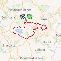
![](/images/other/stat-length.png)
![Randonnée Marche La Feuillée - La Feuillée - Huelgoat - Lac St Michel - Photo](https://media.geolcdn.com/t/1900/400/ext.pjpeg?maxdim=2&url=https%3A%2F%2Fservices.sitytrail.com%2FGeolivesWS%2FDownloadMedia.ashx%3FTrailID%3D864600%26Media%3Dfix__20171119120434.jpg)
La Feuillée - Huelgoat - Lac St Michel
olibreizh
Utilisateur
![Longueur](/images/other/stat-length.png)
![Altitude max](https://static1.geolcdn.com/siteimages/upload/files/1508320355ic_sort_altitude_max_24dp.png)
![Dénivelé positif](https://static1.geolcdn.com/siteimages/upload/files/1508320355ic_sort_den_pos_24dp.png)
![Km-Effort](/images/other/stat-length.png)
![Altitude min](https://static1.geolcdn.com/siteimages/upload/files/1508320355ic_sort_altitude_min_24dp.png)
![Dénivelé négatif](https://static1.geolcdn.com/siteimages/upload/files/1508320355ic_sort_den_neg_24dp.png)
![Boucle](https://static1.geolcdn.com/siteimages/upload/files/16400158638029165_repeat_loop_refresh_sync_direction_icon.png)
![Marche](https://static1.geolcdn.com/sitytour/trail-icons/101.png)
11h03
Difficulté : Moyen
![Scannez ce code QR pour ouvrir la randonnée dans l'application SityTrail](https://capi.geolives.com/qq0zvz2zws4bq2lad0pu/sitytour/trails/864600/qr.png?size=200)
Application GPS de randonnée GRATUITE
À propos
Randonnée Marche de 47 km à découvrir à Bretagne, Finistère, La Feuillée. Cette randonnée est proposée par olibreizh.
Description
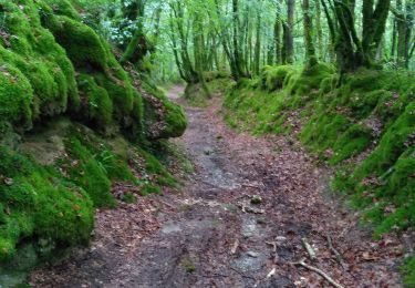
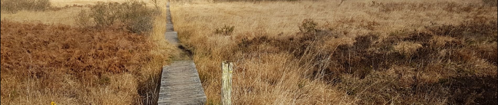
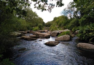
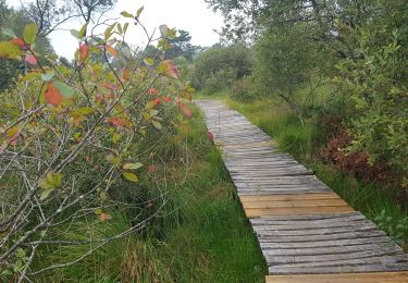
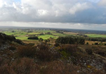
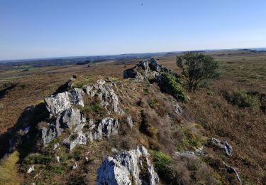
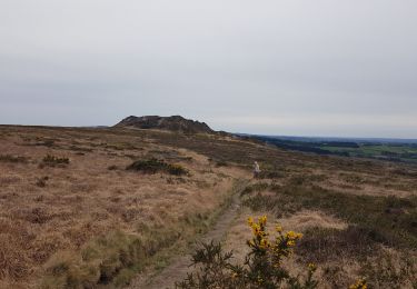
Un grand tour de deux jours de marche avec bivouac au départ de La Feuillée. Ce trajet empreinte beaucoup de chemins, peu de routes. Parcours très varié dans ses paysages entre forêt de Huelgoat, et tourbières de la réserve de Saint Michel (Lac de Brennilis). Marche réalisée en novembre 2017. Certains passages sont très humides, attention à être bien chaussé.
Localisation
Commentaires
Randonnées à proximité
![Randonnée Marche Brennilis - BRENNILIS - Photo](https://media.geolcdn.com/t/375/260/6e50cc19-3f4b-431a-97d4-ac04ab141fcb.jpg&format=jpg&maxdim=2)
![Marche Marche](https://static1.geolcdn.com/sitytour/trail-icons/101.png)
![Randonnée Marche Brennilis - GR_37_EE_11_Brennilis_St-Rivoal_20200810 - Photo](https://media.geolcdn.com/t/375/260/0b8f7b53-5fb7-445b-b4ed-cfdc9fc70396.jpg&format=jpg&maxdim=2)
![Marche Marche](https://static1.geolcdn.com/sitytour/trail-icons/101.png)
Marche
![](/images/other/stat-length.png)
![](https://static1.geolcdn.com/siteimages/upload/files/16400158638029165_repeat_loop_refresh_sync_direction_icon.png)
![Randonnée Marche Botmeur - Roc'h Bichourel - Botmeur - Photo](https://media.geolcdn.com/t/375/260/ext.jpg?maxdim=2&url=https%3A%2F%2Fservices.sitytrail.com%2FGeolivesWS%2FDownloadMedia.ashx%3FTrailID%3D191436%26Media%3D15024_3.jpg)
![Marche Marche](https://static1.geolcdn.com/sitytour/trail-icons/101.png)
Marche
![](/images/other/stat-length.png)
![](https://static1.geolcdn.com/siteimages/upload/files/16400158638029165_repeat_loop_refresh_sync_direction_icon.png)
![Randonnée Marche La Feuillée - 2023-10-08 Roc'h trévezel - Roc'h ruz - Photo](https://media.geolcdn.com/t/375/260/d8895edc-d4c1-401b-9e6a-1edf2c8902a5.jpg&format=jpg&maxdim=2)
![Marche Marche](https://static1.geolcdn.com/sitytour/trail-icons/101.png)
Marche
![](/images/other/stat-length.png)
![](https://static1.geolcdn.com/siteimages/upload/files/16400158638029165_repeat_loop_refresh_sync_direction_icon.png)
![Randonnée Marche La Feuillée - Roc'h 'n Roc'h - Photo](https://media.geolcdn.com/t/375/260/47c13971-e504-451a-b0a8-d2e15e402a97.jpg&format=jpg&maxdim=2)
![Marche Marche](https://static1.geolcdn.com/sitytour/trail-icons/101.png)
Marche
![](/images/other/stat-length.png)
![](https://static1.geolcdn.com/siteimages/upload/files/16400158638029165_repeat_loop_refresh_sync_direction_icon.png)
![Randonnée A pied Berrien - Circuit de l'abbaye du Relec - Photo](https://media.geolcdn.com/t/375/260/2092cde2-aa91-4a91-8f69-04318fbe31bd.jpeg&format=jpg&maxdim=2)
![A pied A pied](https://static1.geolcdn.com/sitytour/trail-icons/100.png)
A pied
![](/images/other/stat-length.png)
![](https://static1.geolcdn.com/siteimages/upload/files/16400158638029165_repeat_loop_refresh_sync_direction_icon.png)
![Randonnée Marche Brennilis - Tour du Lac de Brennilis - Photo](https://media.geolcdn.com/t/375/260/fc3e1795-923b-4d83-9c8e-8d10c71501fd.jpg&format=jpg&maxdim=2)
![Marche Marche](https://static1.geolcdn.com/sitytour/trail-icons/101.png)
Marche
![](/images/other/stat-length.png)
![](https://static1.geolcdn.com/siteimages/upload/files/16400158638029165_repeat_loop_refresh_sync_direction_icon.png)
![Randonnée Marche Brennilis - brennilis saint rivoal - Photo](https://media.geolcdn.com/t/375/260/aeb1938e-6b3c-4d22-9f3f-cb12225f364a.jpg&format=jpg&maxdim=2)
![Marche Marche](https://static1.geolcdn.com/sitytour/trail-icons/101.png)
Marche
![](/images/other/stat-length.png)
![](https://static1.geolcdn.com/siteimages/upload/files/16400158638029165_repeat_loop_refresh_sync_direction_icon.png)
![Randonnée Marche La Feuillée - La FEUILLÉE - Photo](https://media.geolcdn.com/t/375/260/4e348592-a9f8-437e-9275-446c82d79284.jpg&format=jpg&maxdim=2)
![Marche Marche](https://static1.geolcdn.com/sitytour/trail-icons/101.png)