![](/images/other/stat-length.png)
![Randonnée Marche Liège - Grivegnée - Terril Basse Ransy Nord - Vaux-sous-chèvremont - Photo](https://media.geolcdn.com/t/1900/400/ext.pjpeg?maxdim=2&url=https%3A%2F%2Fservices.sitytrail.com%2FGeolivesWS%2FDownloadMedia.ashx%3FTrailID%3D86109%26Media%3D20110928192711.jpeg)
Grivegnée - Terril Basse Ransy Nord - Vaux-sous-chèvremont
pscheven
Utilisateur ADMINGUIDE
![Longueur](/images/other/stat-length.png)
Longueur
3,2 km
![Altitude max](https://static1.geolcdn.com/siteimages/upload/files/1508320355ic_sort_altitude_max_24dp.png)
Altitude max
130 m
![Dénivelé positif](https://static1.geolcdn.com/siteimages/upload/files/1508320355ic_sort_den_pos_24dp.png)
Dénivelé positif
42 m
![Km-Effort](/images/other/stat-length.png)
Km-Effort
3,8 km
![Altitude min](https://static1.geolcdn.com/siteimages/upload/files/1508320355ic_sort_altitude_min_24dp.png)
Altitude min
90 m
![Dénivelé négatif](https://static1.geolcdn.com/siteimages/upload/files/1508320355ic_sort_den_neg_24dp.png)
Dénivelé négatif
59 m
![Boucle](https://static1.geolcdn.com/siteimages/upload/files/16400158638029165_repeat_loop_refresh_sync_direction_icon.png)
Boucle
Non
Date de création :
2014-12-10 00:00:00.0
Dernière modification :
2022-03-29 14:13:25.275
![Marche](https://static1.geolcdn.com/sitytour/trail-icons/101.png)
45m
Difficulté : Très facile
![Scannez ce code QR pour ouvrir la randonnée dans l'application SityTrail](https://capi.geolives.com/qq0zvz2zws4bq2lad0pu/sitytour/trails/86109/qr.png?size=200)
Application GPS de randonnée GRATUITE
À propos
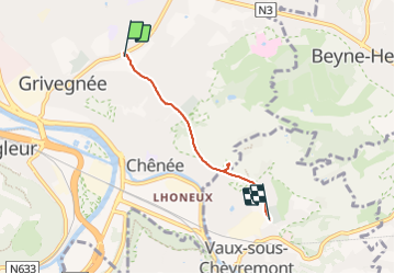
Randonnée Marche de 3,2 km à découvrir à Wallonie, Liège, Liège. Cette randonnée est proposée par pscheven.
Description
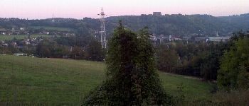
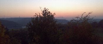
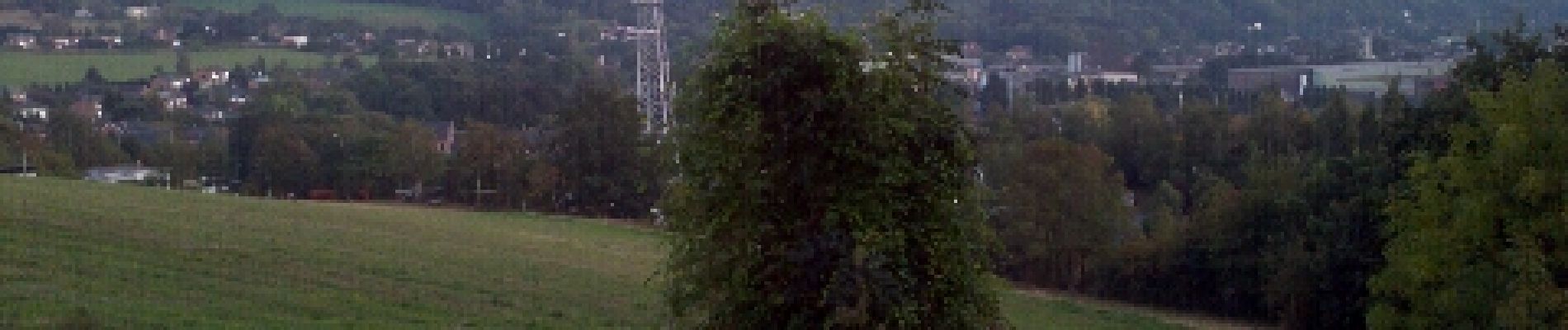
Balade principalement sur le R.A.V.E.L. (ancienne ligne 38) reliant Grivegnée à Vaux-sous-Chèvremont. Très accessible et à plat, à l'exception de la montée au sommet du Terril Basse Ransy Nord, où il y a un point de vue sur tous les environs.
Localisation
Pays :
Belgique
Région :
Wallonie
Département/Province :
Liège
Commune :
Liège
Localité :
Grivegnée
Départ:(Dec)
Départ:(UTM)
684939 ; 5611053 (31U) N.
Commentaires
Randonnées à proximité
![Randonnée Marche Chaudfontaine - RB-Lg-21_Chaudfontaine_via-racc-1-et-2 - Photo](https://media.geolcdn.com/t/375/260/ext.jpg?maxdim=2&url=https%3A%2F%2Fservices.sitytrail.com%2FGeolivesWS%2FDownloadMedia.ashx%3FTrailID%3D400756%26Media%3Db4e5d748-2e9a-46aa-887f-e41bafbe80d7.jpg)
![Marche Marche](https://static1.geolcdn.com/sitytour/trail-icons/101.png)
RB-Lg-21_Chaudfontaine_via-racc-1-et-2
Marche
Difficile
(9)
Chaudfontaine,
Wallonie,
Liège,
Belgique
![](/images/other/stat-length.png)
11,6 km | 16,5 km-effort
3h 45min
![](https://static1.geolcdn.com/siteimages/upload/files/16400158638029165_repeat_loop_refresh_sync_direction_icon.png)
Oui
![Randonnée Marche Chaudfontaine - RB-Lg-21_Chaudfontaine - Photo](https://media.geolcdn.com/t/375/260/ext.jpg?maxdim=2&url=https%3A%2F%2Fservices.sitytrail.com%2FGeolivesWS%2FDownloadMedia.ashx%3FTrailID%3D400753%26Media%3D0173f844-fd8a-4443-984d-43fa65695365.jpg)
![Marche Marche](https://static1.geolcdn.com/sitytour/trail-icons/101.png)
RB-Lg-21_Chaudfontaine
Marche
(14)
Chaudfontaine,
Wallonie,
Liège,
Belgique
![](/images/other/stat-length.png)
18 km | 26 km-effort
5h 56min
![](https://static1.geolcdn.com/siteimages/upload/files/16400158638029165_repeat_loop_refresh_sync_direction_icon.png)
Oui
![Randonnée Marche Chaudfontaine - Chaudfontaine, Natura 2000 - Des sites qui valent le détour, Lg7 - Photo](https://media.geolcdn.com/t/375/260/ext.jpg?maxdim=2&url=https%3A%2F%2Fservices.sitytrail.com%2FGeolivesWS%2FDownloadMedia.ashx%3FTrailID%3D188128%26Media%3Df5c5efa3-ad1d-47ec-bc6a-d75c5f96ada1.JPG)
![Marche Marche](https://static1.geolcdn.com/sitytour/trail-icons/101.png)
Chaudfontaine, Natura 2000 - Des sites qui valent le détour, Lg7
Marche
Difficile
(14)
Chaudfontaine,
Wallonie,
Liège,
Belgique
![](/images/other/stat-length.png)
5,3 km | 8,7 km-effort
1h 48min
![](https://static1.geolcdn.com/siteimages/upload/files/16400158638029165_repeat_loop_refresh_sync_direction_icon.png)
Oui
![Randonnée Marche Liège - Nuit du scoutisme - Liège - Photo](https://media.geolcdn.com/t/375/260/9ee5fcc5-2ed6-4f9c-9105-1fa3b4422f73.jpg&format=jpg&maxdim=2)
![Marche Marche](https://static1.geolcdn.com/sitytour/trail-icons/101.png)
Nuit du scoutisme - Liège
Marche
Facile
(12)
Liège,
Wallonie,
Liège,
Belgique
![](/images/other/stat-length.png)
4,2 km | 6 km-effort
1h 19min
![](https://static1.geolcdn.com/siteimages/upload/files/16400158638029165_repeat_loop_refresh_sync_direction_icon.png)
Oui
![Randonnée Marche Liège - coteaux de la citadelle liège - Photo](https://media.geolcdn.com/t/375/260/ext.jpg?maxdim=2&url=https%3A%2F%2Fservices.sitytrail.com%2FGeolivesWS%2FDownloadMedia.ashx%3FTrailID%3D114030%26Media%3D89e4d7f6-fadf-43e4-96ab-3cccd7baadb9.jpg)
![Marche Marche](https://static1.geolcdn.com/sitytour/trail-icons/101.png)
coteaux de la citadelle liège
Marche
Moyen
(6)
Liège,
Wallonie,
Liège,
Belgique
![](/images/other/stat-length.png)
14,3 km | 19,8 km-effort
7h 4min
![](https://static1.geolcdn.com/siteimages/upload/files/16400158638029165_repeat_loop_refresh_sync_direction_icon.png)
Oui
![Randonnée Marche Liège - RL-GG-10_Angleur_Nessonvaux - Photo](https://media.geolcdn.com/t/375/260/04d5e1fb-7fbe-4c80-8636-73a8d0ed7b0e.jpg&format=jpg&maxdim=2)
![Marche Marche](https://static1.geolcdn.com/sitytour/trail-icons/101.png)
RL-GG-10_Angleur_Nessonvaux
Marche
Très difficile
(2)
Liège,
Wallonie,
Liège,
Belgique
![](/images/other/stat-length.png)
22 km | 32 km-effort
6h 27min
![](https://static1.geolcdn.com/siteimages/upload/files/16400158638029165_repeat_loop_refresh_sync_direction_icon.png)
Non
![Randonnée Marche Chaudfontaine - RB-Lg-21_Chaudfontaine_via-racc-1 - Photo](https://media.geolcdn.com/t/375/260/ext.jpg?maxdim=2&url=https%3A%2F%2Fservices.sitytrail.com%2FGeolivesWS%2FDownloadMedia.ashx%3FTrailID%3D400755%26Media%3Db4e5d748-2e9a-46aa-887f-e41bafbe80d7.jpg)
![Marche Marche](https://static1.geolcdn.com/sitytour/trail-icons/101.png)
RB-Lg-21_Chaudfontaine_via-racc-1
Marche
Très difficile
(3)
Chaudfontaine,
Wallonie,
Liège,
Belgique
![](/images/other/stat-length.png)
14,9 km | 22 km-effort
5h 1min
![](https://static1.geolcdn.com/siteimages/upload/files/16400158638029165_repeat_loop_refresh_sync_direction_icon.png)
Oui
![Randonnée Marche Liège - liege st lambert versant gauche entre ville et nature - Photo](https://media.geolcdn.com/t/375/260/88c52680-ebe2-4244-8d59-4bcee560958c.jpg&format=jpg&maxdim=2)
![Marche Marche](https://static1.geolcdn.com/sitytour/trail-icons/101.png)
liege st lambert versant gauche entre ville et nature
Marche
Moyen
(1)
Liège,
Wallonie,
Liège,
Belgique
![](/images/other/stat-length.png)
10,5 km | 14 km-effort
2h 31min
![](https://static1.geolcdn.com/siteimages/upload/files/16400158638029165_repeat_loop_refresh_sync_direction_icon.png)
Oui
![Randonnée Marche Chaudfontaine - La découverte de Sauheid et rocher du bout du monde - Photo](https://media.geolcdn.com/t/375/260/13dd1432-7408-4af2-9183-0d845172c158.jpg&format=jpg&maxdim=2)
![Marche Marche](https://static1.geolcdn.com/sitytour/trail-icons/101.png)
La découverte de Sauheid et rocher du bout du monde
Marche
Moyen
(1)
Chaudfontaine,
Wallonie,
Liège,
Belgique
![](/images/other/stat-length.png)
7,8 km | 10,2 km-effort
2h 18min
![](https://static1.geolcdn.com/siteimages/upload/files/16400158638029165_repeat_loop_refresh_sync_direction_icon.png)
Oui