![](/images/other/stat-length.png)
![Randonnée Marche Palluaud - PALLUAUD La Lizonne - Photo](https://media.geolcdn.com/t/1900/400/ext.pjpeg?maxdim=2&url=https%3A%2F%2Fstatic1.geolcdn.com%2Fsiteimages%2Fupload%2Ffiles%2F1553511878bg_sport_marche.png)
PALLUAUD La Lizonne
dorcier
Utilisateur
![Longueur](/images/other/stat-length.png)
Longueur
9,1 km
![Altitude max](https://static1.geolcdn.com/siteimages/upload/files/1508320355ic_sort_altitude_max_24dp.png)
Altitude max
172 m
![Dénivelé positif](https://static1.geolcdn.com/siteimages/upload/files/1508320355ic_sort_den_pos_24dp.png)
Dénivelé positif
171 m
![Km-Effort](/images/other/stat-length.png)
Km-Effort
11,4 km
![Altitude min](https://static1.geolcdn.com/siteimages/upload/files/1508320355ic_sort_altitude_min_24dp.png)
Altitude min
59 m
![Dénivelé négatif](https://static1.geolcdn.com/siteimages/upload/files/1508320355ic_sort_den_neg_24dp.png)
Dénivelé négatif
171 m
![Boucle](https://static1.geolcdn.com/siteimages/upload/files/16400158638029165_repeat_loop_refresh_sync_direction_icon.png)
Boucle
Oui
Date de création :
2018-04-17 11:58:33.349
Dernière modification :
2018-04-17 11:58:33.349
![Marche](https://static1.geolcdn.com/sitytour/trail-icons/101.png)
2h27
Difficulté : Facile
![Scannez ce code QR pour ouvrir la randonnée dans l'application SityTrail](https://capi.geolives.com/qq0zvz2zws4bq2lad0pu/sitytour/trails/855707/qr.png?size=200)
Application GPS de randonnée GRATUITE
À propos
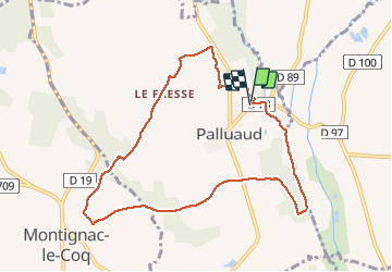
Randonnée Marche de 9,1 km à découvrir à Nouvelle-Aquitaine, Charente, Palluaud. Cette randonnée est proposée par dorcier.
Description
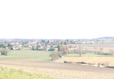
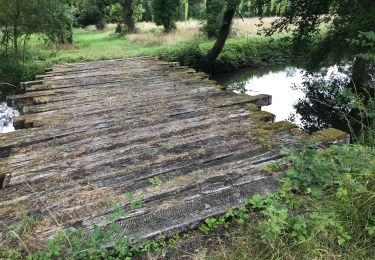
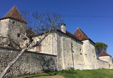
Départ ancienne Laiterie. A la sortie de palluaud sur la D78 direction Verteillac, avant le pont qui franchi le canal du moulin du Champatier. Balisage jaune. A voir : église de palluaud, La lizonne et son canal, Moulin de Nègre-Mure, Points de vue sur le village.
Localisation
Pays :
France
Région :
Nouvelle-Aquitaine
Département/Province :
Charente
Commune :
Palluaud
Localité :
Unknown
Départ:(Dec)
Départ:(UTM)
284784 ; 5025705 (31T) N.
Commentaires
Randonnées à proximité
![Randonnée Marche Saint-Séverin - Saint Séverin ( Le haut Dexmier) - Photo](https://media.geolcdn.com/t/375/260/75335f6f-aeb6-4ead-aed5-3458d0a63862.jpg&format=jpg&maxdim=2)
![Marche Marche](https://static1.geolcdn.com/sitytour/trail-icons/101.png)
Saint Séverin ( Le haut Dexmier)
Marche
Difficile
Saint-Séverin,
Nouvelle-Aquitaine,
Charente,
France
![](/images/other/stat-length.png)
9,8 km | 12,2 km-effort
2h 39min
![](https://static1.geolcdn.com/siteimages/upload/files/16400158638029165_repeat_loop_refresh_sync_direction_icon.png)
Oui
![Randonnée Marche Palluaud - Palluaud - Photo](https://media.geolcdn.com/t/375/260/8932bd06-8059-4477-ac71-57863d93ee85.jpg&format=jpg&maxdim=2)
![Marche Marche](https://static1.geolcdn.com/sitytour/trail-icons/101.png)
Palluaud
Marche
Moyen
Palluaud,
Nouvelle-Aquitaine,
Charente,
France
![](/images/other/stat-length.png)
10,7 km | 13,5 km-effort
2h 50min
![](https://static1.geolcdn.com/siteimages/upload/files/16400158638029165_repeat_loop_refresh_sync_direction_icon.png)
Oui
![Randonnée Marche Pillac - Pillac 2 - Photo](https://media.geolcdn.com/t/375/260/ext.jpg?maxdim=2&url=https%3A%2F%2Fstatic1.geolcdn.com%2Fsiteimages%2Fupload%2Ffiles%2F1553511878bg_sport_marche.png)
![Marche Marche](https://static1.geolcdn.com/sitytour/trail-icons/101.png)
Pillac 2
Marche
Très facile
Pillac,
Nouvelle-Aquitaine,
Charente,
France
![](/images/other/stat-length.png)
10,6 km | 13,3 km-effort
2h 35min
![](https://static1.geolcdn.com/siteimages/upload/files/16400158638029165_repeat_loop_refresh_sync_direction_icon.png)
Oui
![Randonnée Marche Bouteilles-Saint-Sébastien - Bouteillles-Saint-Sébastien - Photo](https://media.geolcdn.com/t/375/260/ext.jpg?maxdim=2&url=https%3A%2F%2Fservices.sitytrail.com%2FGeolivesWS%2FDownloadMedia.ashx%3FTrailID%3D715728%26Media%3D20170316153141.jpg)
![Marche Marche](https://static1.geolcdn.com/sitytour/trail-icons/101.png)
Bouteillles-Saint-Sébastien
Marche
Facile
Bouteilles-Saint-Sébastien,
Nouvelle-Aquitaine,
Dordogne,
France
![](/images/other/stat-length.png)
8,4 km | 11 km-effort
2h 21min
![](https://static1.geolcdn.com/siteimages/upload/files/16400158638029165_repeat_loop_refresh_sync_direction_icon.png)
Oui
![Randonnée Marche Salles-Lavalette - Salles-Lavalette - Photo](https://media.geolcdn.com/t/375/260/ext.jpg?maxdim=2&url=https%3A%2F%2Fstatic1.geolcdn.com%2Fsiteimages%2Fupload%2Ffiles%2F1553511878bg_sport_marche.png)
![Marche Marche](https://static1.geolcdn.com/sitytour/trail-icons/101.png)
Salles-Lavalette
Marche
Moyen
Salles-Lavalette,
Nouvelle-Aquitaine,
Charente,
France
![](/images/other/stat-length.png)
11,6 km | 14,2 km-effort
3h 4min
![](https://static1.geolcdn.com/siteimages/upload/files/16400158638029165_repeat_loop_refresh_sync_direction_icon.png)
Oui
![Randonnée Marche Salles-Lavalette - Le Breuil - Salles Lavallette - Photo](https://media.geolcdn.com/t/375/260/ext.jpg?maxdim=2&url=https%3A%2F%2Fstatic1.geolcdn.com%2Fsiteimages%2Fupload%2Ffiles%2F1553511878bg_sport_marche.png)
![Marche Marche](https://static1.geolcdn.com/sitytour/trail-icons/101.png)
Le Breuil - Salles Lavallette
Marche
Moyen
Salles-Lavalette,
Nouvelle-Aquitaine,
Charente,
France
![](/images/other/stat-length.png)
5,2 km | 6,2 km-effort
1h 41min
![](https://static1.geolcdn.com/siteimages/upload/files/16400158638029165_repeat_loop_refresh_sync_direction_icon.png)
Oui
![Randonnée Marche Pillac - Pillac - Photo](https://media.geolcdn.com/t/375/260/ext.jpg?maxdim=2&url=https%3A%2F%2Fstatic1.geolcdn.com%2Fsiteimages%2Fupload%2Ffiles%2F1553511878bg_sport_marche.png)
![Marche Marche](https://static1.geolcdn.com/sitytour/trail-icons/101.png)
Pillac
Marche
Facile
(1)
Pillac,
Nouvelle-Aquitaine,
Charente,
France
![](/images/other/stat-length.png)
11,2 km | 14 km-effort
2h 52min
![](https://static1.geolcdn.com/siteimages/upload/files/16400158638029165_repeat_loop_refresh_sync_direction_icon.png)
Oui
![Randonnée Marche Montignac-le-Coq - montignac le coq - Photo](https://media.geolcdn.com/t/375/260/ext.jpg?maxdim=2&url=https%3A%2F%2Fstatic1.geolcdn.com%2Fsiteimages%2Fupload%2Ffiles%2F1553511878bg_sport_marche.png)
![Marche Marche](https://static1.geolcdn.com/sitytour/trail-icons/101.png)
montignac le coq
Marche
Facile
Montignac-le-Coq,
Nouvelle-Aquitaine,
Charente,
France
![](/images/other/stat-length.png)
9,1 km | 11,3 km-effort
2h 16min
![](https://static1.geolcdn.com/siteimages/upload/files/16400158638029165_repeat_loop_refresh_sync_direction_icon.png)
Oui