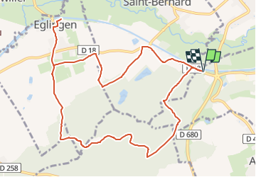
![](/images/other/stat-length.png)
![Randonnée Marche Heidwiller - 68 Heidwiller - Eglingen - Photo](https://media.geolcdn.com/t/1900/400/ext.pjpeg?maxdim=2&url=https%3A%2F%2Fstatic1.geolcdn.com%2Fsiteimages%2Fupload%2Ffiles%2F1553511878bg_sport_marche.png)
68 Heidwiller - Eglingen
E.BURCK
Utilisateur
![Longueur](/images/other/stat-length.png)
![Altitude max](https://static1.geolcdn.com/siteimages/upload/files/1508320355ic_sort_altitude_max_24dp.png)
![Dénivelé positif](https://static1.geolcdn.com/siteimages/upload/files/1508320355ic_sort_den_pos_24dp.png)
![Km-Effort](/images/other/stat-length.png)
![Altitude min](https://static1.geolcdn.com/siteimages/upload/files/1508320355ic_sort_altitude_min_24dp.png)
![Dénivelé négatif](https://static1.geolcdn.com/siteimages/upload/files/1508320355ic_sort_den_neg_24dp.png)
![Boucle](https://static1.geolcdn.com/siteimages/upload/files/16400158638029165_repeat_loop_refresh_sync_direction_icon.png)
![Marche](https://static1.geolcdn.com/sitytour/trail-icons/101.png)
3h08
Difficulté : Facile
![Scannez ce code QR pour ouvrir la randonnée dans l'application SityTrail](https://capi.geolives.com/qq0zvz2zws4bq2lad0pu/sitytour/trails/851179/qr.png?size=200)
Application GPS de randonnée GRATUITE
À propos
Randonnée Marche de 11,7 km à découvrir à Grand Est, Haut-Rhin, Heidwiller. Cette randonnée est proposée par E.BURCK.
Description
Une balade facile vers Eglingen, dans le Sundgau. (223 m de dénivelé et 12 km)
ACCÈS :
- Sur la D18 le long du canal entre Heidwiller et Eglingen(voir plan)
PARKING:
- à droite, environ 100 m après le rond point, en direction de Eglingen.
47.65746 , 7.2190058 ou
N 47°39'27" E 7°13'09"
RESTAURATION :
Restaurant à l'Arbre Vert, 18 rue Principale à Eglingen.
Tél.: 03 89 25 30 29
Localisation
Commentaires
Randonnées à proximité
![Randonnée Marche Carspach - Entraînement Trek Tignes septembre 5024 - Photo](https://media.geolcdn.com/t/375/260/139dc24e-6c0b-495f-b090-ab282f1645f4.jpg&format=jpg&maxdim=2)
![Marche Marche](https://static1.geolcdn.com/sitytour/trail-icons/101.png)
Marche
![](/images/other/stat-length.png)
![](https://static1.geolcdn.com/siteimages/upload/files/16400158638029165_repeat_loop_refresh_sync_direction_icon.png)
![Randonnée Marche Illfurth - Illfurth Luemschwillrr Obermorschwiller - Photo](https://media.geolcdn.com/t/375/260/46e592e4-24b9-41f2-97e3-216d8904300e.jpg&format=jpg&maxdim=2)
![Marche Marche](https://static1.geolcdn.com/sitytour/trail-icons/101.png)
Marche
![](/images/other/stat-length.png)
![](https://static1.geolcdn.com/siteimages/upload/files/16400158638029165_repeat_loop_refresh_sync_direction_icon.png)
![Randonnée Marche Carspach - Carspach (21/02/2019) - Photo](https://media.geolcdn.com/t/375/260/cfc93ddd-5602-4f71-87a7-bb22a3daa167.jpeg&format=jpg&maxdim=2)
![Marche Marche](https://static1.geolcdn.com/sitytour/trail-icons/101.png)
Marche
![](/images/other/stat-length.png)
![](https://static1.geolcdn.com/siteimages/upload/files/16400158638029165_repeat_loop_refresh_sync_direction_icon.png)
![Randonnée Marche Walheim - Walheim-Illfuhrt (1-3-2018) - Photo](https://media.geolcdn.com/t/375/260/ext.jpg?maxdim=2&url=https%3A%2F%2Fservices.sitytrail.com%2FGeolivesWS%2FDownloadMedia.ashx%3FTrailID%3D915181%26Media%3Dfix__20180301135138.jpg)
![Marche Marche](https://static1.geolcdn.com/sitytour/trail-icons/101.png)
Marche
![](/images/other/stat-length.png)
![](https://static1.geolcdn.com/siteimages/upload/files/16400158638029165_repeat_loop_refresh_sync_direction_icon.png)
![Randonnée Course à pied Walheim - noel - Photo](https://media.geolcdn.com/t/375/260/ext.jpg?maxdim=2&url=https%3A%2F%2Fservices.sitytrail.com%2FGeolivesWS%2FDownloadMedia.ashx%3FTrailID%3D167185%26Media%3D20121225131934.jpeg)
![Course à pied Course à pied](https://static1.geolcdn.com/sitytour/trail-icons/103.png)
![Randonnée Course à pied Walheim - noel - Photo](https://media.geolcdn.com/t/375/260/ext.jpg?maxdim=2&url=https%3A%2F%2Fservices.sitytrail.com%2FGeolivesWS%2FDownloadMedia.ashx%3FTrailID%3D167140%26Media%3D20121225125537.jpeg)
![Course à pied Course à pied](https://static1.geolcdn.com/sitytour/trail-icons/103.png)
![Randonnée V.T.T. Walheim - 2010-10-31 - 10h56m09 - Photo](https://media.geolcdn.com/t/375/260/ext.jpg?maxdim=2&url=https%3A%2F%2Fservices.sitytrail.com%2FGeolivesWS%2FDownloadMedia.ashx%3FTrailID%3D47733%26Media%3Dimage8.jpg)
![V.T.T. V.T.T.](https://static1.geolcdn.com/sitytour/trail-icons/202.png)
V.T.T.
![](/images/other/stat-length.png)
![](https://static1.geolcdn.com/siteimages/upload/files/16400158638029165_repeat_loop_refresh_sync_direction_icon.png)
![Randonnée Marche Carspach - Carspach (13 février 2020) - Photo](https://media.geolcdn.com/t/375/260/ff38c100-fa9e-45ab-ae7a-e26a88b871b6.jpg&format=jpg&maxdim=2)
![Marche Marche](https://static1.geolcdn.com/sitytour/trail-icons/101.png)
Marche
![](/images/other/stat-length.png)
![](https://static1.geolcdn.com/siteimages/upload/files/16400158638029165_repeat_loop_refresh_sync_direction_icon.png)
![Randonnée Randonnée équestre Spechbach - Circuit Sundgau - Spechbach le Bas - Oltingue - Photo](https://media.geolcdn.com/t/375/260/67d01f95-6a14-459c-882c-17e90c3f6823.jpg&format=jpg&maxdim=2)
![Randonnée équestre Randonnée équestre](https://static1.geolcdn.com/sitytour/trail-icons/301.png)
Randonnée équestre
![](/images/other/stat-length.png)
![](https://static1.geolcdn.com/siteimages/upload/files/16400158638029165_repeat_loop_refresh_sync_direction_icon.png)