![](/images/other/stat-length.png)
VTT autour de Thuin
pascalou73
Utilisateur GUIDE
![Longueur](/images/other/stat-length.png)
Longueur
44 km
![Altitude max](https://static1.geolcdn.com/siteimages/upload/files/1508320355ic_sort_altitude_max_24dp.png)
Altitude max
223 m
![Dénivelé positif](https://static1.geolcdn.com/siteimages/upload/files/1508320355ic_sort_den_pos_24dp.png)
Dénivelé positif
569 m
![Km-Effort](/images/other/stat-length.png)
Km-Effort
52 km
![Altitude min](https://static1.geolcdn.com/siteimages/upload/files/1508320355ic_sort_altitude_min_24dp.png)
Altitude min
111 m
![Dénivelé négatif](https://static1.geolcdn.com/siteimages/upload/files/1508320355ic_sort_den_neg_24dp.png)
Dénivelé négatif
570 m
![Boucle](https://static1.geolcdn.com/siteimages/upload/files/16400158638029165_repeat_loop_refresh_sync_direction_icon.png)
Boucle
Oui
Date de création :
2018-04-17 11:05:25.734
Dernière modification :
2018-04-17 11:05:25.734
![V.T.T.](https://static1.geolcdn.com/sitytour/trail-icons/202.png)
3h21
Difficulté : Moyen
![Scannez ce code QR pour ouvrir la randonnée dans l'application SityTrail](https://capi.geolives.com/qq0zvz2zws4bq2lad0pu/sitytour/trails/848556/qr.png?size=200)
Application GPS de randonnée GRATUITE
À propos
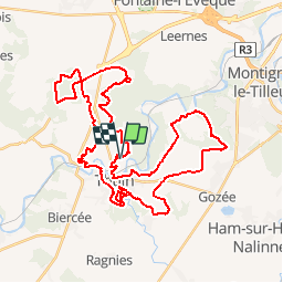
Randonnée V.T.T. de 44 km à découvrir à Wallonie, Hainaut, Thuin. Cette randonnée est proposée par pascalou73.
Description
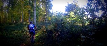
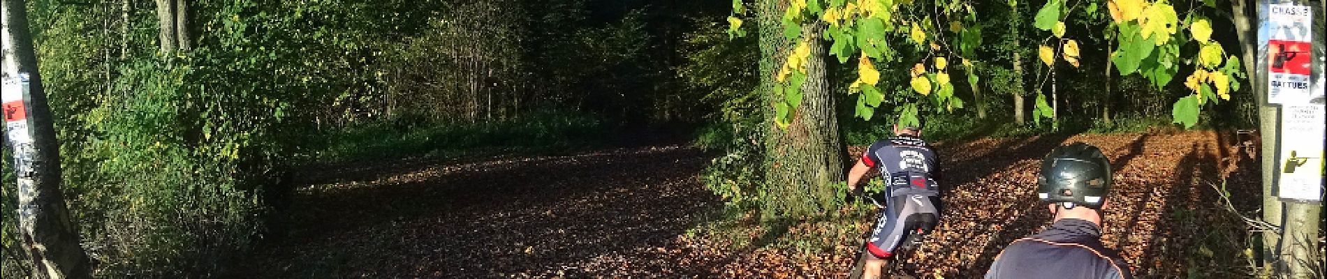
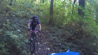
Un VTT dans la région de Thuin qui va vous faire découvrie la région au fil des sentiers et pas les beaux petits chemins . la randonnée avec quelque belle décente dans des beaux boisent sans difficulté .Bref 43 km de belle rando.
Points d'intérêt
Localisation
Pays :
Belgique
Région :
Wallonie
Département/Province :
Hainaut
Commune :
Thuin
Localité :
Thuin
Départ:(Dec)
Départ:(UTM)
591907 ; 5578162 (31U) N.
Commentaires
Randonnées à proximité
![Randonnée Marche Fontaine-l'Évêque - de l'Abbaye d'Aulne au hameau de Hourpes - Thuin - Photo](https://media.geolcdn.com/t/375/260/a34a09f7-2ebf-4334-b3ab-6307c79b316f.jpeg&format=jpg&maxdim=2)
![Marche Marche](https://static1.geolcdn.com/sitytour/trail-icons/101.png)
de l'Abbaye d'Aulne au hameau de Hourpes - Thuin
Marche
Très facile
(2)
Fontaine-l'Évêque,
Wallonie,
Hainaut,
Belgique
![](/images/other/stat-length.png)
8,7 km | 10,9 km-effort
3h 16min
![](https://static1.geolcdn.com/siteimages/upload/files/16400158638029165_repeat_loop_refresh_sync_direction_icon.png)
Oui
![Randonnée Marche Thuin - La balade du Bois des Waibes. - Photo](https://media.geolcdn.com/t/375/260/ext.jpg?maxdim=2&url=https%3A%2F%2Fservices.sitytrail.com%2FGeolivesWS%2FDownloadMedia.ashx%3FTrailID%3D846785%26Media%3D2a15c231-0cbe-4107-9b4e-b0ca15c25a1f.jpg)
![Marche Marche](https://static1.geolcdn.com/sitytour/trail-icons/101.png)
La balade du Bois des Waibes.
Marche
Facile
(4)
Thuin,
Wallonie,
Hainaut,
Belgique
![](/images/other/stat-length.png)
9,9 km | 12 km-effort
2h 41min
![](https://static1.geolcdn.com/siteimages/upload/files/16400158638029165_repeat_loop_refresh_sync_direction_icon.png)
Oui
![Randonnée Marche Montigny-le-Tilleul - Balade en Val de Sambre - De Landelies à l'Abbaye d'Aulne - Photo](https://media.geolcdn.com/t/375/260/ext.jpg?maxdim=2&url=https%3A%2F%2Fservices.sitytrail.com%2FGeolivesWS%2FDownloadMedia.ashx%3FTrailID%3D498562%26Media%3D0c817a37-45f6-4c22-ab94-a572de965186.JPG)
![Marche Marche](https://static1.geolcdn.com/sitytour/trail-icons/101.png)
Balade en Val de Sambre - De Landelies à l'Abbaye d'Aulne
Marche
Très facile
(1)
Montigny-le-Tilleul,
Wallonie,
Hainaut,
Belgique
![](/images/other/stat-length.png)
6,6 km | 8 km-effort
1h 49min
![](https://static1.geolcdn.com/siteimages/upload/files/16400158638029165_repeat_loop_refresh_sync_direction_icon.png)
Oui
![Marche Marche](https://static1.geolcdn.com/sitytour/trail-icons/101.png)
BE-Montigny-le-Tilleul - Landelies - Aulne - 2
Marche
Très facile
(1)
Montigny-le-Tilleul,
Wallonie,
Hainaut,
Belgique
![](/images/other/stat-length.png)
7,1 km | 9,6 km-effort
2h 4min
![](https://static1.geolcdn.com/siteimages/upload/files/16400158638029165_repeat_loop_refresh_sync_direction_icon.png)
Oui
![Randonnée Marche Lobbes - Balade à Mont-Sainte-Geneviève - Photo](https://media.geolcdn.com/t/375/260/ext.jpg?maxdim=2&url=https%3A%2F%2Fservices.sitytrail.com%2FGeolivesWS%2FDownloadMedia.ashx%3FTrailID%3D378767%26Media%3D9ad7b20e-c031-407f-875d-742351009cf4.jpg)
![Marche Marche](https://static1.geolcdn.com/sitytour/trail-icons/101.png)
Balade à Mont-Sainte-Geneviève
Marche
Très facile
(3)
Lobbes,
Wallonie,
Hainaut,
Belgique
![](/images/other/stat-length.png)
9,1 km | 10,4 km-effort
2h 18min
![](https://static1.geolcdn.com/siteimages/upload/files/16400158638029165_repeat_loop_refresh_sync_direction_icon.png)
Oui
![Randonnée Marche Thuin - RB-Ha-08 - Thuin - Via allongement - Photo](https://media.geolcdn.com/t/375/260/ext.jpg?maxdim=2&url=https%3A%2F%2Fservices.sitytrail.com%2FGeolivesWS%2FDownloadMedia.ashx%3FTrailID%3D218762%26Media%3D7e0b1de5-2210-4f38-aa84-2fca8ae33ab8.jpg)
![Marche Marche](https://static1.geolcdn.com/sitytour/trail-icons/101.png)
RB-Ha-08 - Thuin - Via allongement
Marche
Très difficile
(2)
Thuin,
Wallonie,
Hainaut,
Belgique
![](/images/other/stat-length.png)
25 km | 32 km-effort
7h 12min
![](https://static1.geolcdn.com/siteimages/upload/files/16400158638029165_repeat_loop_refresh_sync_direction_icon.png)
Oui
![Randonnée Marche Thuin - RB-Ha-08 - Thuin - Photo](https://media.geolcdn.com/t/375/260/ext.jpg?maxdim=2&url=https%3A%2F%2Fservices.sitytrail.com%2FGeolivesWS%2FDownloadMedia.ashx%3FTrailID%3D179601%26Media%3D33d5cfdf-1096-4ca0-9209-00c5bbfd32f4.jpg)
![Marche Marche](https://static1.geolcdn.com/sitytour/trail-icons/101.png)
RB-Ha-08 - Thuin
Marche
Très difficile
(2)
Thuin,
Wallonie,
Hainaut,
Belgique
![](/images/other/stat-length.png)
22 km | 28 km-effort
6h 26min
![](https://static1.geolcdn.com/siteimages/upload/files/16400158638029165_repeat_loop_refresh_sync_direction_icon.png)
Oui
![Randonnée Marche Thuin - Thuin - De la Ville Haute à la Ville Basse - Photo](https://media.geolcdn.com/t/375/260/ext.jpg?maxdim=2&url=https%3A%2F%2Fservices.sitytrail.com%2FGeolivesWS%2FDownloadMedia.ashx%3FTrailID%3D96827%26Media%3Da38cc2d0-85a8-4251-9b00-ce6dea30fa93.JPG)
![Marche Marche](https://static1.geolcdn.com/sitytour/trail-icons/101.png)
Thuin - De la Ville Haute à la Ville Basse
Marche
Facile
(4)
Thuin,
Wallonie,
Hainaut,
Belgique
![](/images/other/stat-length.png)
4,5 km | 6,6 km-effort
1h 20min
![](https://static1.geolcdn.com/siteimages/upload/files/16400158638029165_repeat_loop_refresh_sync_direction_icon.png)
Oui
![Randonnée Marche Lobbes - LOBBES (vers Hourpes) dép RHS - Photo](https://media.geolcdn.com/t/375/260/d9a7042e-0c53-41c5-a007-94b83a09ecc3.jpg&format=jpg&maxdim=2)
![Marche Marche](https://static1.geolcdn.com/sitytour/trail-icons/101.png)
LOBBES (vers Hourpes) dép RHS
Marche
Moyen
(1)
Lobbes,
Wallonie,
Hainaut,
Belgique
![](/images/other/stat-length.png)
7,2 km | 8,6 km-effort
2h 1min
![](https://static1.geolcdn.com/siteimages/upload/files/16400158638029165_repeat_loop_refresh_sync_direction_icon.png)
Oui