![](/images/other/stat-length.png)
![Randonnée V.T.T. Fareins - Fareins messimy lurcy francheleins montceaux beybleu sapeins chaleins retour - Photo](https://media.geolcdn.com/t/1900/400/ext.pjpeg?maxdim=2&url=https%3A%2F%2Fstatic1.geolcdn.com%2Fsiteimages%2Fupload%2Ffiles%2F1524743154velo.jpg)
Fareins messimy lurcy francheleins montceaux beybleu sapeins chaleins retour
plusdego
Utilisateur
![Longueur](/images/other/stat-length.png)
Longueur
36 km
![Altitude max](https://static1.geolcdn.com/siteimages/upload/files/1508320355ic_sort_altitude_max_24dp.png)
Altitude max
274 m
![Dénivelé positif](https://static1.geolcdn.com/siteimages/upload/files/1508320355ic_sort_den_pos_24dp.png)
Dénivelé positif
359 m
![Km-Effort](/images/other/stat-length.png)
Km-Effort
41 km
![Altitude min](https://static1.geolcdn.com/siteimages/upload/files/1508320355ic_sort_altitude_min_24dp.png)
Altitude min
175 m
![Dénivelé négatif](https://static1.geolcdn.com/siteimages/upload/files/1508320355ic_sort_den_neg_24dp.png)
Dénivelé négatif
357 m
![Boucle](https://static1.geolcdn.com/siteimages/upload/files/16400158638029165_repeat_loop_refresh_sync_direction_icon.png)
Boucle
Oui
Date de création :
2018-04-17 10:34:27.466
Dernière modification :
2018-04-17 10:34:27.466
![V.T.T.](https://static1.geolcdn.com/sitytour/trail-icons/202.png)
2h44
Difficulté : Facile
![Scannez ce code QR pour ouvrir la randonnée dans l'application SityTrail](https://capi.geolives.com/qq0zvz2zws4bq2lad0pu/sitytour/trails/844464/qr.png?size=200)
Application GPS de randonnée GRATUITE
À propos
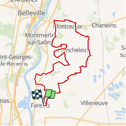
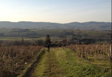
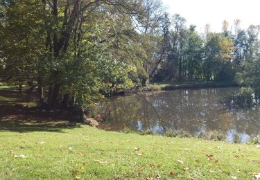
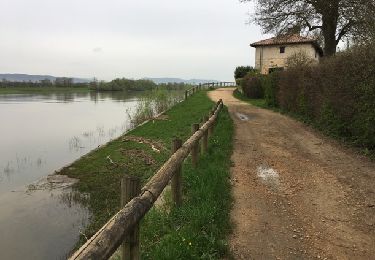
Randonnée V.T.T. de 36 km à découvrir à Auvergne-Rhône-Alpes, Ain, Fareins. Cette randonnée est proposée par plusdego.
Description
Grande boucle de 36km au départ de Fareins. Arrivée à Messimy par les champs, puis Lurcy, Francheleins, Montceaux, retour par Beybleu, Sapeins et Chaleins
Localisation
Pays :
France
Région :
Auvergne-Rhône-Alpes
Département/Province :
Ain
Commune :
Fareins
Localité :
Unknown
Départ:(Dec)
Départ:(UTM)
636731 ; 5097718 (31T) N.
Commentaires
Randonnées à proximité
![Randonnée Marche Villefranche-sur-Saône - Itinérant Beaujolais etape 1 Villefranche sur Saone - Le Flagolet - Photo](https://media.geolcdn.com/t/375/260/265892a0-89c7-47ac-89f3-06f9bc929d8c.jpg&format=jpg&maxdim=2)
![Marche Marche](https://static1.geolcdn.com/sitytour/trail-icons/101.png)
Itinérant Beaujolais etape 1 Villefranche sur Saone - Le Flagolet
Marche
Moyen
Villefranche-sur-Saône,
Auvergne-Rhône-Alpes,
Rhône,
France
![](/images/other/stat-length.png)
20 km | 25 km-effort
4h 43min
![](https://static1.geolcdn.com/siteimages/upload/files/16400158638029165_repeat_loop_refresh_sync_direction_icon.png)
Non
![Randonnée Marche Lurcy - Lurcy (16 km - D. 134 m) - Photo](https://media.geolcdn.com/t/375/260/e2042645-0d0c-4f8d-a036-e57dec048f59.jpg&format=jpg&maxdim=2)
![Marche Marche](https://static1.geolcdn.com/sitytour/trail-icons/101.png)
Lurcy (16 km - D. 134 m)
Marche
Difficile
Lurcy,
Auvergne-Rhône-Alpes,
Ain,
France
![](/images/other/stat-length.png)
16,2 km | 18 km-effort
4h 57min
![](https://static1.geolcdn.com/siteimages/upload/files/16400158638029165_repeat_loop_refresh_sync_direction_icon.png)
Oui
![Randonnée Marche Ars-sur-Formans - Ars-s-formans (Cibeins) - Photo](https://media.geolcdn.com/t/375/260/ec90bbcc-0957-43a3-97d6-baf804ca93d7.jpg&format=jpg&maxdim=2)
![Marche Marche](https://static1.geolcdn.com/sitytour/trail-icons/101.png)
Ars-s-formans (Cibeins)
Marche
Facile
Ars-sur-Formans,
Auvergne-Rhône-Alpes,
Ain,
France
![](/images/other/stat-length.png)
4,3 km | 5,3 km-effort
1h 14min
![](https://static1.geolcdn.com/siteimages/upload/files/16400158638029165_repeat_loop_refresh_sync_direction_icon.png)
Oui
![Randonnée Marche Ars-sur-Formans - Ars-Sur-Formans (13,5 km) - Photo](https://media.geolcdn.com/t/375/260/dbdc7be9-af92-44af-8e66-bcc2600e0638.jpg&format=jpg&maxdim=2)
![Marche Marche](https://static1.geolcdn.com/sitytour/trail-icons/101.png)
Ars-Sur-Formans (13,5 km)
Marche
Moyen
Ars-sur-Formans,
Auvergne-Rhône-Alpes,
Ain,
France
![](/images/other/stat-length.png)
13,5 km | 15,7 km-effort
3h 25min
![](https://static1.geolcdn.com/siteimages/upload/files/16400158638029165_repeat_loop_refresh_sync_direction_icon.png)
Oui
![Randonnée Marche Chaleins - chaneins - Photo](https://media.geolcdn.com/t/375/260/ext.jpg?maxdim=2&url=https%3A%2F%2Fservices.sitytrail.com%2FGeolivesWS%2FDownloadMedia.ashx%3FTrailID%3D266784%26Media%3Dfix__20140405115211.jpg)
![Marche Marche](https://static1.geolcdn.com/sitytour/trail-icons/101.png)
chaneins
Marche
Facile
Chaleins,
Auvergne-Rhône-Alpes,
Ain,
France
![](/images/other/stat-length.png)
12,8 km | 14,3 km-effort
4h 2min
![](https://static1.geolcdn.com/siteimages/upload/files/16400158638029165_repeat_loop_refresh_sync_direction_icon.png)
Oui
![Randonnée Marche Chaleins - chaneins - Photo](https://media.geolcdn.com/t/375/260/ext.jpg?maxdim=2&url=https%3A%2F%2Fservices.sitytrail.com%2FGeolivesWS%2FDownloadMedia.ashx%3FTrailID%3D263439%26Media%3Dfix__20140405150716.jpg)
![Marche Marche](https://static1.geolcdn.com/sitytour/trail-icons/101.png)
chaneins
Marche
Facile
Chaleins,
Auvergne-Rhône-Alpes,
Ain,
France
![](/images/other/stat-length.png)
12,8 km | 14,3 km-effort
4h 2min
![](https://static1.geolcdn.com/siteimages/upload/files/16400158638029165_repeat_loop_refresh_sync_direction_icon.png)
Oui
![Randonnée Marche Limas - Limas - Photo](https://media.geolcdn.com/t/375/260/ext.jpg?maxdim=2&url=https%3A%2F%2Fservices.sitytrail.com%2FGeolivesWS%2FDownloadMedia.ashx%3FTrailID%3D166962%26Media%3D20121223151415.jpg)
![Marche Marche](https://static1.geolcdn.com/sitytour/trail-icons/101.png)
![Randonnée Marche Jassans-Riottier - de Jassans à Ars - Photo](https://media.geolcdn.com/t/375/260/69609df8-c7a8-4c16-85d6-78de1862e8ac.jpg&format=jpg&maxdim=2)
![Marche Marche](https://static1.geolcdn.com/sitytour/trail-icons/101.png)
de Jassans à Ars
Marche
Très facile
Jassans-Riottier,
Auvergne-Rhône-Alpes,
Ain,
France
![](/images/other/stat-length.png)
19,5 km | 23 km-effort
6h 1min
![](https://static1.geolcdn.com/siteimages/upload/files/16400158638029165_repeat_loop_refresh_sync_direction_icon.png)
Oui
![Marche Marche](https://static1.geolcdn.com/sitytour/trail-icons/101.png)
rando tarot
Marche
Moyen
Messimy-sur-Saône,
Auvergne-Rhône-Alpes,
Ain,
France
![](/images/other/stat-length.png)
11,3 km | 12,6 km-effort
1h 54min
![](https://static1.geolcdn.com/siteimages/upload/files/16400158638029165_repeat_loop_refresh_sync_direction_icon.png)
Oui