![](/images/other/stat-length.png)
![Randonnée Marche Cros - Le Pouget- Mas de Boissière - Photo](https://media.geolcdn.com/t/1900/400/ext.pjpeg?maxdim=2&url=https%3A%2F%2Fservices.sitytrail.com%2FGeolivesWS%2FDownloadMedia.ashx%3FTrailID%3D838631%26Media%3D20171001163348.jpg)
Le Pouget- Mas de Boissière
zoe.vienne
Utilisateur
![Longueur](/images/other/stat-length.png)
![Altitude max](https://static1.geolcdn.com/siteimages/upload/files/1508320355ic_sort_altitude_max_24dp.png)
![Dénivelé positif](https://static1.geolcdn.com/siteimages/upload/files/1508320355ic_sort_den_pos_24dp.png)
![Km-Effort](/images/other/stat-length.png)
![Altitude min](https://static1.geolcdn.com/siteimages/upload/files/1508320355ic_sort_altitude_min_24dp.png)
![Dénivelé négatif](https://static1.geolcdn.com/siteimages/upload/files/1508320355ic_sort_den_neg_24dp.png)
![Boucle](https://static1.geolcdn.com/siteimages/upload/files/16400158638029165_repeat_loop_refresh_sync_direction_icon.png)
![Marche](https://static1.geolcdn.com/sitytour/trail-icons/101.png)
2h29
Difficulté : Facile
![Scannez ce code QR pour ouvrir la randonnée dans l'application SityTrail](https://capi.geolives.com/qq0zvz2zws4bq2lad0pu/sitytour/trails/838631/qr.png?size=200)
Application GPS de randonnée GRATUITE
À propos
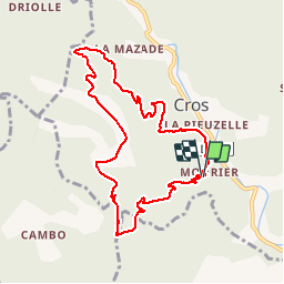
Randonnée Marche de 9,5 km à découvrir à Occitanie, Gard, Cros. Cette randonnée est proposée par zoe.vienne.
Description
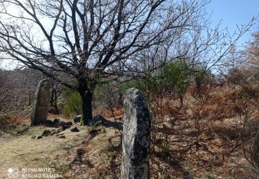
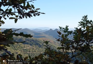
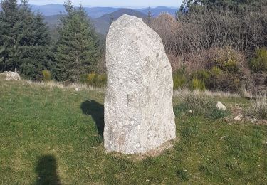
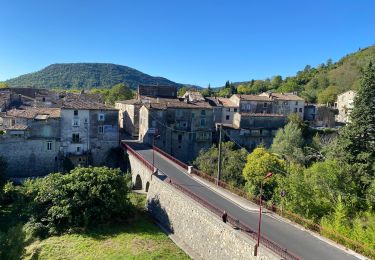
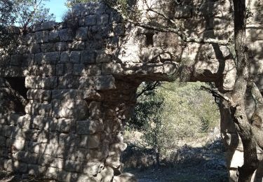
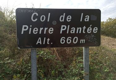
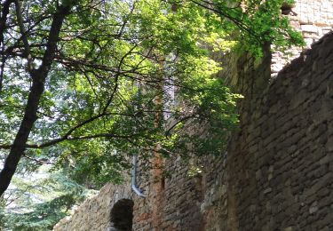
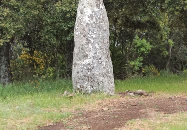
À trois km au nord de St Hippolyte du Fort, boucle faite le 1er Octobre 2017 dans le sens inverse des aiguilles d'une montre, ce qui donne une longue montée sur une large piste forestière et une descente plus raide dans un chemin caillouteux. Peut être qu'en sens inverse cette randonnée aurait plus d'intérêt. Sinon, belle vue sur les Jumelles et beau paysage d'automne.
Localisation
Commentaires
Randonnées à proximité
![Randonnée Marche La Cadière-et-Cambo - CAMBO - MONTAGNE DE LA FAGE - 7.6Km - 02h20 - Dénivelé 285 m - Photo](https://media.geolcdn.com/t/375/260/ext.jpg?maxdim=2&url=https%3A%2F%2Fstatic1.geolcdn.com%2Fsiteimages%2Fupload%2Ffiles%2F1553511878bg_sport_marche.png)
![Marche Marche](https://static1.geolcdn.com/sitytour/trail-icons/101.png)
Marche
![](/images/other/stat-length.png)
![](https://static1.geolcdn.com/siteimages/upload/files/16400158638029165_repeat_loop_refresh_sync_direction_icon.png)
![Randonnée A pied Colognac - 30 du Cayrel au Camp Barrat 20/02/24 - Photo](https://media.geolcdn.com/t/375/260/db46be15-0ade-41ce-a4c3-6381b880347f.jpg&format=jpg&maxdim=2)
![A pied A pied](https://static1.geolcdn.com/sitytour/trail-icons/100.png)
A pied
![](/images/other/stat-length.png)
![](https://static1.geolcdn.com/siteimages/upload/files/16400158638029165_repeat_loop_refresh_sync_direction_icon.png)
![Randonnée Marche Sumène - 30 les crêtes des cagnasses,a la fage 15/11/23 - Photo](https://media.geolcdn.com/t/375/260/327f6ae4-95a4-43dc-ae64-f238198e92ec.jpg&format=jpg&maxdim=2)
![Marche Marche](https://static1.geolcdn.com/sitytour/trail-icons/101.png)
Marche
![](/images/other/stat-length.png)
![](https://static1.geolcdn.com/siteimages/upload/files/16400158638029165_repeat_loop_refresh_sync_direction_icon.png)
![Randonnée Marche Saint-Roman-de-Codières - st roman de codieres - Photo](https://media.geolcdn.com/t/375/260/20d79857-0660-4ad5-8bfa-f1464b2570fb.jpg&format=jpg&maxdim=2)
![Marche Marche](https://static1.geolcdn.com/sitytour/trail-icons/101.png)
Marche
![](/images/other/stat-length.png)
![](https://static1.geolcdn.com/siteimages/upload/files/16400158638029165_repeat_loop_refresh_sync_direction_icon.png)
![Randonnée Vélo de route Saint-Hippolyte-du-Fort - St hippolyte Sumène - Photo](https://media.geolcdn.com/t/375/260/e61d3303-5780-495f-9530-f8ecc86038ae.jpg&format=jpg&maxdim=2)
![Vélo de route Vélo de route](https://static1.geolcdn.com/sitytour/trail-icons/201.png)
Vélo de route
![](/images/other/stat-length.png)
![](https://static1.geolcdn.com/siteimages/upload/files/16400158638029165_repeat_loop_refresh_sync_direction_icon.png)
![Randonnée Marche Saint-Hippolyte-du-Fort - 30 Roquefourcade 16-03_23 - Photo](https://media.geolcdn.com/t/375/260/8923796a-cfdc-4ce7-92ba-22653b18afc1.jpg&format=jpg&maxdim=2)
![Marche Marche](https://static1.geolcdn.com/sitytour/trail-icons/101.png)
Marche
![](/images/other/stat-length.png)
![](https://static1.geolcdn.com/siteimages/upload/files/16400158638029165_repeat_loop_refresh_sync_direction_icon.png)
![Randonnée Marche Saint-Roman-de-Codières - St Roman de Codiere 2 - Photo](https://media.geolcdn.com/t/375/260/eecdea35-1ea5-474d-b466-cf9b8758dea8.jpg&format=jpg&maxdim=2)
![Marche Marche](https://static1.geolcdn.com/sitytour/trail-icons/101.png)
Marche
![](/images/other/stat-length.png)
![](https://static1.geolcdn.com/siteimages/upload/files/16400158638029165_repeat_loop_refresh_sync_direction_icon.png)
![Randonnée Marche Sumène - Cézas Prieuré St Martin - Photo](https://media.geolcdn.com/t/375/260/dfff80b7-8e5e-4059-89ec-0caf5a49dd9b.jpg&format=jpg&maxdim=2)
![Marche Marche](https://static1.geolcdn.com/sitytour/trail-icons/101.png)
Marche
![](/images/other/stat-length.png)
![](https://static1.geolcdn.com/siteimages/upload/files/16400158638029165_repeat_loop_refresh_sync_direction_icon.png)
![Randonnée Marche Saint-Roman-de-Codières - St Roman de Codiere - Photo](https://media.geolcdn.com/t/375/260/a15ccfea-a4ed-409a-afe0-88f149361477.jpg&format=jpg&maxdim=2)
![Marche Marche](https://static1.geolcdn.com/sitytour/trail-icons/101.png)
Marche
![](/images/other/stat-length.png)
![](https://static1.geolcdn.com/siteimages/upload/files/16400158638029165_repeat_loop_refresh_sync_direction_icon.png)