![](/images/other/stat-length.png)
![Randonnée Marche La Gripperie-Saint-Symphorien - Massone - Photo](https://media.geolcdn.com/t/1900/400/ext.pjpeg?maxdim=2&url=https%3A%2F%2Fstatic1.geolcdn.com%2Fsiteimages%2Fupload%2Ffiles%2F1553511878bg_sport_marche.png)
Massone
Bobol
Utilisateur
![Longueur](/images/other/stat-length.png)
Longueur
8,7 km
![Altitude max](https://static1.geolcdn.com/siteimages/upload/files/1508320355ic_sort_altitude_max_24dp.png)
Altitude max
29 m
![Dénivelé positif](https://static1.geolcdn.com/siteimages/upload/files/1508320355ic_sort_den_pos_24dp.png)
Dénivelé positif
66 m
![Km-Effort](/images/other/stat-length.png)
Km-Effort
9,5 km
![Altitude min](https://static1.geolcdn.com/siteimages/upload/files/1508320355ic_sort_altitude_min_24dp.png)
Altitude min
0 m
![Dénivelé négatif](https://static1.geolcdn.com/siteimages/upload/files/1508320355ic_sort_den_neg_24dp.png)
Dénivelé négatif
66 m
![Boucle](https://static1.geolcdn.com/siteimages/upload/files/16400158638029165_repeat_loop_refresh_sync_direction_icon.png)
Boucle
Oui
Date de création :
2018-04-16 23:48:43.434
Dernière modification :
2018-04-16 23:48:43.434
![Marche](https://static1.geolcdn.com/sitytour/trail-icons/101.png)
2h01
Difficulté : Facile
![Scannez ce code QR pour ouvrir la randonnée dans l'application SityTrail](https://capi.geolives.com/qq0zvz2zws4bq2lad0pu/sitytour/trails/837946/qr.png?size=200)
Application GPS de randonnée GRATUITE
À propos
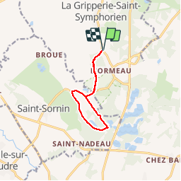
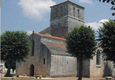
Randonnée Marche de 8,7 km à découvrir à Nouvelle-Aquitaine, Charente-Maritime, La Gripperie-Saint-Symphorien. Cette randonnée est proposée par Bobol.
Description
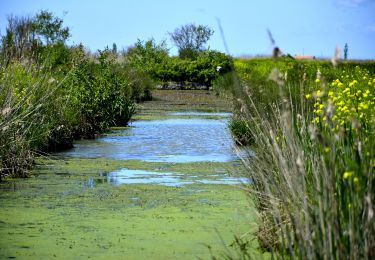
Un petite ballade à faire pour se dégourdir les papattes de derrière. Aucune difficulté et très ombragé.
Localisation
Pays :
France
Région :
Nouvelle-Aquitaine
Département/Province :
Charente-Maritime
Commune :
La Gripperie-Saint-Symphorien
Localité :
Unknown
Départ:(Dec)
Départ:(UTM)
659427 ; 5072520 (30T) N.
Commentaires
Randonnées à proximité
![Randonnée Marche Saint-Jean-d'Angle - St jean d angle - Photo](https://media.geolcdn.com/t/375/260/ext.jpg?maxdim=2&url=https%3A%2F%2Fmedia.geolcdn.com%2Ff%2Ffb2e35ec-d490-4db5-a4d0-5391365facb9.jpg)
![Marche Marche](https://static1.geolcdn.com/sitytour/trail-icons/101.png)
St jean d angle
Marche
Moyen
Saint-Jean-d'Angle,
Nouvelle-Aquitaine,
Charente-Maritime,
France
![](/images/other/stat-length.png)
9,9 km | 10,9 km-effort
3h 33min
![](https://static1.geolcdn.com/siteimages/upload/files/16400158638029165_repeat_loop_refresh_sync_direction_icon.png)
Oui
![Randonnée Marche Saint-Sornin - St Sornin-La tour de Broue - Photo](https://media.geolcdn.com/t/375/260/ext.jpg?maxdim=2&url=https%3A%2F%2Fservices.sitytrail.com%2FGeolivesWS%2FDownloadMedia.ashx%3FTrailID%3D561824%26Media%3D6d02cf9e-0995-4778-9f47-a24105334027.JPG)
![Marche Marche](https://static1.geolcdn.com/sitytour/trail-icons/101.png)
St Sornin-La tour de Broue
Marche
Facile
Saint-Sornin,
Nouvelle-Aquitaine,
Charente-Maritime,
France
![](/images/other/stat-length.png)
9,9 km | 11 km-effort
2h 24min
![](https://static1.geolcdn.com/siteimages/upload/files/16400158638029165_repeat_loop_refresh_sync_direction_icon.png)
Oui
![Randonnée Marche Saint-Jean-d'Angle - St Jean d'Angle - Photo](https://media.geolcdn.com/t/375/260/ext.jpg?maxdim=2&url=https%3A%2F%2Fstatic1.geolcdn.com%2Fsiteimages%2Fupload%2Ffiles%2F1553511878bg_sport_marche.png)
![Marche Marche](https://static1.geolcdn.com/sitytour/trail-icons/101.png)
St Jean d'Angle
Marche
Moyen
(1)
Saint-Jean-d'Angle,
Nouvelle-Aquitaine,
Charente-Maritime,
France
![](/images/other/stat-length.png)
12,1 km | 13,4 km-effort
Inconnu
![](https://static1.geolcdn.com/siteimages/upload/files/16400158638029165_repeat_loop_refresh_sync_direction_icon.png)
Oui
![Randonnée Marche Nieulle-sur-Seudre - 17 Nieulle sur Seudre 7km - Photo](https://media.geolcdn.com/t/375/260/ext.jpg?maxdim=2&url=https%3A%2F%2Fmedia.geolcdn.com%2Ff%2F1f42c532-6db1-4be3-9d6e-53b89725eb97.JPG)
![Marche Marche](https://static1.geolcdn.com/sitytour/trail-icons/101.png)
17 Nieulle sur Seudre 7km
Marche
Facile
Nieulle-sur-Seudre,
Nouvelle-Aquitaine,
Charente-Maritime,
France
![](/images/other/stat-length.png)
6,8 km | 7,2 km-effort
1h 37min
![](https://static1.geolcdn.com/siteimages/upload/files/16400158638029165_repeat_loop_refresh_sync_direction_icon.png)
Oui
![Randonnée Marche Saint-Sornin - Saint Sorin - Photo](https://media.geolcdn.com/t/375/260/ext.jpg?maxdim=2&url=https%3A%2F%2Fservices.sitytrail.com%2FGeolivesWS%2FDownloadMedia.ashx%3FTrailID%3D49438%26Media%3Dssor1.png)
![Marche Marche](https://static1.geolcdn.com/sitytour/trail-icons/101.png)
Saint Sorin
Marche
Très facile
Saint-Sornin,
Nouvelle-Aquitaine,
Charente-Maritime,
France
![](/images/other/stat-length.png)
12,9 km | 14,3 km-effort
Inconnu
![](https://static1.geolcdn.com/siteimages/upload/files/16400158638029165_repeat_loop_refresh_sync_direction_icon.png)
Oui
![Randonnée Marche La Gripperie-Saint-Symphorien - 17 la Gripperie - St Jean d'Angle 8km - Photo](https://media.geolcdn.com/t/375/260/ext.jpg?maxdim=2&url=https%3A%2F%2Fstatic1.geolcdn.com%2Fsiteimages%2Fupload%2Ffiles%2F1553511878bg_sport_marche.png)
![Marche Marche](https://static1.geolcdn.com/sitytour/trail-icons/101.png)
17 la Gripperie - St Jean d'Angle 8km
Marche
Moyen
La Gripperie-Saint-Symphorien,
Nouvelle-Aquitaine,
Charente-Maritime,
France
![](/images/other/stat-length.png)
8 km | 8,8 km-effort
1h 59min
![](https://static1.geolcdn.com/siteimages/upload/files/16400158638029165_repeat_loop_refresh_sync_direction_icon.png)
Oui
![Randonnée Marche Sainte-Gemme - 17 Ste Gemme 8km500 - Photo](https://media.geolcdn.com/t/375/260/ext.jpg?maxdim=2&url=https%3A%2F%2Fmedia.geolcdn.com%2Ff%2F0e4cb5cb-98d1-479f-a1be-ab839d718968.JPG)
![Marche Marche](https://static1.geolcdn.com/sitytour/trail-icons/101.png)
17 Ste Gemme 8km500
Marche
Très facile
Sainte-Gemme,
Nouvelle-Aquitaine,
Charente-Maritime,
France
![](/images/other/stat-length.png)
8,5 km | 9,1 km-effort
2h 0min
![](https://static1.geolcdn.com/siteimages/upload/files/16400158638029165_repeat_loop_refresh_sync_direction_icon.png)
Oui
![Randonnée V.T.C. Saint-Sornin - St Sornin St Jean d'Angle 24,5km - Photo](https://media.geolcdn.com/t/375/260/ext.jpg?maxdim=2&url=https%3A%2F%2Fstatic1.geolcdn.com%2Fsiteimages%2Fupload%2Ffiles%2F1524743154velo.jpg)
![V.T.C. V.T.C.](https://static1.geolcdn.com/sitytour/trail-icons/203.png)
St Sornin St Jean d'Angle 24,5km
V.T.C.
Très facile
Saint-Sornin,
Nouvelle-Aquitaine,
Charente-Maritime,
France
![](/images/other/stat-length.png)
25 km | 27 km-effort
Inconnu
![](https://static1.geolcdn.com/siteimages/upload/files/16400158638029165_repeat_loop_refresh_sync_direction_icon.png)
Oui
![Randonnée Marche Champagne - CHAMPAGNE NORD 10km - Photo](https://media.geolcdn.com/t/375/260/ext.jpg?maxdim=2&url=https%3A%2F%2Fstatic1.geolcdn.com%2Fsiteimages%2Fupload%2Ffiles%2F1553511878bg_sport_marche.png)
![Marche Marche](https://static1.geolcdn.com/sitytour/trail-icons/101.png)
CHAMPAGNE NORD 10km
Marche
Moyen
(1)
Champagne,
Nouvelle-Aquitaine,
Charente-Maritime,
France
![](/images/other/stat-length.png)
10 km | 11,3 km-effort
2h 29min
![](https://static1.geolcdn.com/siteimages/upload/files/16400158638029165_repeat_loop_refresh_sync_direction_icon.png)
Oui