![](/images/other/stat-length.png)
![Randonnée Marche Le Fleix - le sac, les cèdres, st avit - Photo](https://media.geolcdn.com/t/1900/400/ext.pjpeg?maxdim=2&url=https%3A%2F%2Fstatic1.geolcdn.com%2Fsiteimages%2Fupload%2Ffiles%2F1553511878bg_sport_marche.png)
le sac, les cèdres, st avit
gersimcar
Utilisateur
![Longueur](/images/other/stat-length.png)
Longueur
10,4 km
![Altitude max](https://static1.geolcdn.com/siteimages/upload/files/1508320355ic_sort_altitude_max_24dp.png)
Altitude max
25 m
![Dénivelé positif](https://static1.geolcdn.com/siteimages/upload/files/1508320355ic_sort_den_pos_24dp.png)
Dénivelé positif
73 m
![Km-Effort](/images/other/stat-length.png)
Km-Effort
11,3 km
![Altitude min](https://static1.geolcdn.com/siteimages/upload/files/1508320355ic_sort_altitude_min_24dp.png)
Altitude min
10 m
![Dénivelé négatif](https://static1.geolcdn.com/siteimages/upload/files/1508320355ic_sort_den_neg_24dp.png)
Dénivelé négatif
73 m
![Boucle](https://static1.geolcdn.com/siteimages/upload/files/16400158638029165_repeat_loop_refresh_sync_direction_icon.png)
Boucle
Oui
Date de création :
2017-09-24 00:00:00.0
Dernière modification :
2020-08-04 17:16:31.167
![Marche](https://static1.geolcdn.com/sitytour/trail-icons/101.png)
3h30
Difficulté : Facile
![Scannez ce code QR pour ouvrir la randonnée dans l'application SityTrail](https://capi.geolives.com/qq0zvz2zws4bq2lad0pu/sitytour/trails/834659/qr.png?size=200)
Application GPS de randonnée GRATUITE
À propos
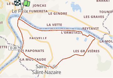
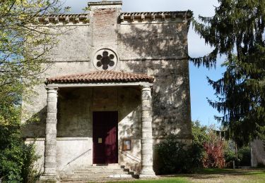
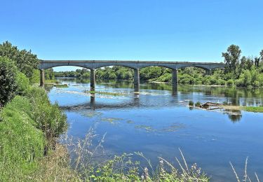
Randonnée Marche de 10,4 km à découvrir à Nouvelle-Aquitaine, Dordogne, Le Fleix. Cette randonnée est proposée par gersimcar.
Description
figues, noix et noisettes sur le chemin ... 3:00 à 3 km/h - avec les douleurs aux jambes et aux orteils coté droit le temps de chercher les fruits!!! réalisé le 2017-09-24
Localisation
Pays :
France
Région :
Nouvelle-Aquitaine
Département/Province :
Dordogne
Commune :
Le Fleix
Localité :
Unknown
Départ:(Dec)
Départ:(UTM)
282369 ; 4972733 (31T) N.
Commentaires
Randonnées à proximité
![Randonnée A pied Le Fleix - Boucle de Gabastou - Photo](https://media.geolcdn.com/t/375/260/18d814c7-f45f-471d-9961-e2b02014db18.jpeg&format=jpg&maxdim=2)
![A pied A pied](https://static1.geolcdn.com/sitytour/trail-icons/100.png)
Boucle de Gabastou
A pied
Facile
Le Fleix,
Nouvelle-Aquitaine,
Dordogne,
France
![](/images/other/stat-length.png)
8,4 km | 10 km-effort
2h 16min
![](https://static1.geolcdn.com/siteimages/upload/files/16400158638029165_repeat_loop_refresh_sync_direction_icon.png)
Non
![Randonnée A pied Le Fleix - Boucle de Cap de fer - Photo](https://media.geolcdn.com/t/375/260/86475a03-e544-4a11-b09f-95948087b74f.jpeg&format=jpg&maxdim=2)
![A pied A pied](https://static1.geolcdn.com/sitytour/trail-icons/100.png)
Boucle de Cap de fer
A pied
Facile
Le Fleix,
Nouvelle-Aquitaine,
Dordogne,
France
![](/images/other/stat-length.png)
5,7 km | 7,7 km-effort
1h 45min
![](https://static1.geolcdn.com/siteimages/upload/files/16400158638029165_repeat_loop_refresh_sync_direction_icon.png)
Non
![Randonnée A pied Le Fleix - Liaison - Photo](https://media.geolcdn.com/t/375/260/ext.jpg?maxdim=2&url=https%3A%2F%2Fstatic1.geolcdn.com%2Fsiteimages%2Fupload%2Ffiles%2F1545311037marcheuse_200dpi.jpg)
![A pied A pied](https://static1.geolcdn.com/sitytour/trail-icons/100.png)
Liaison
A pied
Facile
Le Fleix,
Nouvelle-Aquitaine,
Dordogne,
France
![](/images/other/stat-length.png)
7,7 km | 9,2 km-effort
2h 6min
![](https://static1.geolcdn.com/siteimages/upload/files/16400158638029165_repeat_loop_refresh_sync_direction_icon.png)
Non
![Randonnée V.T.T. Pineuilh - 9 Sainte Foy la Grande-Bazas-St Jacques de Compostelle - Photo](https://media.geolcdn.com/t/375/260/ext.jpg?maxdim=2&url=https%3A%2F%2Fstatic1.geolcdn.com%2Fsiteimages%2Fupload%2Ffiles%2F1524743154velo.jpg)
![V.T.T. V.T.T.](https://static1.geolcdn.com/sitytour/trail-icons/202.png)
9 Sainte Foy la Grande-Bazas-St Jacques de Compostelle
V.T.T.
Difficile
Pineuilh,
Nouvelle-Aquitaine,
Gironde,
France
![](/images/other/stat-length.png)
99 km | 119 km-effort
7h 38min
![](https://static1.geolcdn.com/siteimages/upload/files/16400158638029165_repeat_loop_refresh_sync_direction_icon.png)
Non
![Randonnée Marche Monfaucon - cadillac - Photo](https://media.geolcdn.com/t/375/260/ext.jpg?maxdim=2&url=https%3A%2F%2Fstatic1.geolcdn.com%2Fsiteimages%2Fupload%2Ffiles%2F1553511878bg_sport_marche.png)
![Marche Marche](https://static1.geolcdn.com/sitytour/trail-icons/101.png)
cadillac
Marche
Très facile
Monfaucon,
Nouvelle-Aquitaine,
Dordogne,
France
![](/images/other/stat-length.png)
12,4 km | 14,7 km-effort
3h 12min
![](https://static1.geolcdn.com/siteimages/upload/files/16400158638029165_repeat_loop_refresh_sync_direction_icon.png)
Oui
![Randonnée Marche Le Fleix - moulins et rivière - Photo](https://media.geolcdn.com/t/375/260/ext.jpg?maxdim=2&url=https%3A%2F%2Fstatic1.geolcdn.com%2Fsiteimages%2Fupload%2Ffiles%2F1553511878bg_sport_marche.png)
![Marche Marche](https://static1.geolcdn.com/sitytour/trail-icons/101.png)
moulins et rivière
Marche
Moyen
Le Fleix,
Nouvelle-Aquitaine,
Dordogne,
France
![](/images/other/stat-length.png)
13,1 km | 16 km-effort
6h 0min
![](https://static1.geolcdn.com/siteimages/upload/files/16400158638029165_repeat_loop_refresh_sync_direction_icon.png)
Oui
![Randonnée Marche Le Fleix - Puy Servain - Photo](https://media.geolcdn.com/t/375/260/ext.jpg?maxdim=2&url=https%3A%2F%2Fstatic1.geolcdn.com%2Fsiteimages%2Fupload%2Ffiles%2F1553511878bg_sport_marche.png)
![Marche Marche](https://static1.geolcdn.com/sitytour/trail-icons/101.png)
Puy Servain
Marche
Moyen
Le Fleix,
Nouvelle-Aquitaine,
Dordogne,
France
![](/images/other/stat-length.png)
13,1 km | 16 km-effort
6h 0min
![](https://static1.geolcdn.com/siteimages/upload/files/16400158638029165_repeat_loop_refresh_sync_direction_icon.png)
Oui
![Randonnée Marche Le Fleix - la joubine - Photo](https://media.geolcdn.com/t/375/260/ext.jpg?maxdim=2&url=https%3A%2F%2Fstatic1.geolcdn.com%2Fsiteimages%2Fupload%2Ffiles%2F1553511878bg_sport_marche.png)
![Marche Marche](https://static1.geolcdn.com/sitytour/trail-icons/101.png)
la joubine
Marche
Facile
Le Fleix,
Nouvelle-Aquitaine,
Dordogne,
France
![](/images/other/stat-length.png)
18,5 km | 22 km-effort
5h 24min
![](https://static1.geolcdn.com/siteimages/upload/files/16400158638029165_repeat_loop_refresh_sync_direction_icon.png)
Oui
![Randonnée Marche Monfaucon - gabastou - Photo](https://media.geolcdn.com/t/375/260/ext.jpg?maxdim=2&url=https%3A%2F%2Fstatic1.geolcdn.com%2Fsiteimages%2Fupload%2Ffiles%2F1553511878bg_sport_marche.png)
![Marche Marche](https://static1.geolcdn.com/sitytour/trail-icons/101.png)
gabastou
Marche
Moyen
Monfaucon,
Nouvelle-Aquitaine,
Dordogne,
France
![](/images/other/stat-length.png)
16 km | 19,1 km-effort
3h 35min
![](https://static1.geolcdn.com/siteimages/upload/files/16400158638029165_repeat_loop_refresh_sync_direction_icon.png)
Oui