![](/images/other/stat-length.png)
![Randonnée Marche Oppedette - Boucle des gorges d'Oppedette - Photo](https://media.geolcdn.com/t/1900/400/ext.pjpeg?maxdim=2&url=https%3A%2F%2Fstatic1.geolcdn.com%2Fsiteimages%2Fupload%2Ffiles%2F1553511878bg_sport_marche.png)
Boucle des gorges d'Oppedette
rigol05
Utilisateur
![Longueur](/images/other/stat-length.png)
Longueur
7,1 km
![Altitude max](https://static1.geolcdn.com/siteimages/upload/files/1508320355ic_sort_altitude_max_24dp.png)
Altitude max
532 m
![Dénivelé positif](https://static1.geolcdn.com/siteimages/upload/files/1508320355ic_sort_den_pos_24dp.png)
Dénivelé positif
236 m
![Km-Effort](/images/other/stat-length.png)
Km-Effort
10,2 km
![Altitude min](https://static1.geolcdn.com/siteimages/upload/files/1508320355ic_sort_altitude_min_24dp.png)
Altitude min
414 m
![Dénivelé négatif](https://static1.geolcdn.com/siteimages/upload/files/1508320355ic_sort_den_neg_24dp.png)
Dénivelé négatif
227 m
![Boucle](https://static1.geolcdn.com/siteimages/upload/files/16400158638029165_repeat_loop_refresh_sync_direction_icon.png)
Boucle
Oui
Date de création :
2018-04-16 23:15:48.701
Dernière modification :
2018-04-16 23:15:48.701
![Marche](https://static1.geolcdn.com/sitytour/trail-icons/101.png)
2h14
Difficulté : Moyen
![Scannez ce code QR pour ouvrir la randonnée dans l'application SityTrail](https://capi.geolives.com/qq0zvz2zws4bq2lad0pu/sitytour/trails/832975/qr.png?size=200)
Application GPS de randonnée GRATUITE
À propos
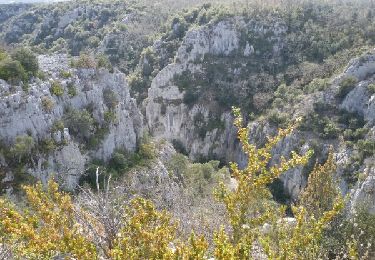
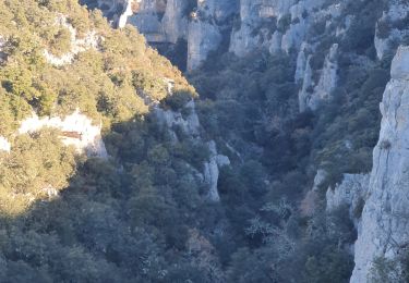
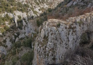
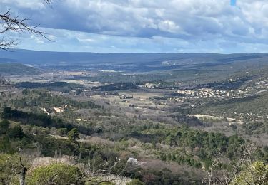
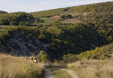
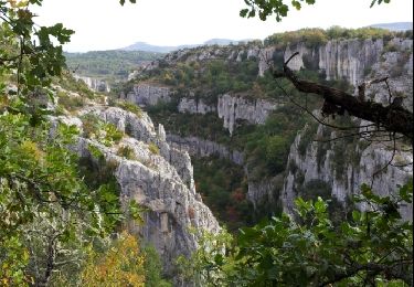
Randonnée Marche de 7,1 km à découvrir à Provence-Alpes-Côte d'Azur, Alpes-de-Haute-Provence, Oppedette. Cette randonnée est proposée par rigol05.
Description
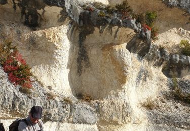
Itinéraire entièrement balisé au départ du parking des gorges pour profiter du panorama à partir des belvédères
Localisation
Pays :
France
Région :
Provence-Alpes-Côte d'Azur
Département/Province :
Alpes-de-Haute-Provence
Commune :
Oppedette
Localité :
Unknown
Départ:(Dec)
Départ:(UTM)
707687 ; 4867708 (31T) N.
Commentaires
Randonnées à proximité
![Randonnée Marche Oppedette - Gorges d'Oppedette(06-04-2015) - Photo](https://media.geolcdn.com/t/375/260/ext.jpg?maxdim=2&url=https%3A%2F%2Fservices.sitytrail.com%2FGeolivesWS%2FDownloadMedia.ashx%3FTrailID%3D404746%26Media%3Dfix__20150406152511.jpg)
![Marche Marche](https://static1.geolcdn.com/sitytour/trail-icons/101.png)
Gorges d'Oppedette(06-04-2015)
Marche
Moyen
(1)
Oppedette,
Provence-Alpes-Côte d'Azur,
Alpes-de-Haute-Provence,
France
![](/images/other/stat-length.png)
9,4 km | 12,8 km-effort
3h 26min
![](https://static1.geolcdn.com/siteimages/upload/files/16400158638029165_repeat_loop_refresh_sync_direction_icon.png)
Oui
![Randonnée Marche Oppedette - 2024-02-02 Oppedette Valsaintes Saut du moine - Photo](https://media.geolcdn.com/t/375/260/d37a3973-9a90-4474-879d-da972103a322.jpg&format=jpg&maxdim=2)
![Marche Marche](https://static1.geolcdn.com/sitytour/trail-icons/101.png)
2024-02-02 Oppedette Valsaintes Saut du moine
Marche
Très difficile
Oppedette,
Provence-Alpes-Côte d'Azur,
Alpes-de-Haute-Provence,
France
![](/images/other/stat-length.png)
16,8 km | 24 km-effort
5h 21min
![](https://static1.geolcdn.com/siteimages/upload/files/16400158638029165_repeat_loop_refresh_sync_direction_icon.png)
Oui
![Randonnée Marche Oppedette - LES Gorges d' oppedette - Photo](https://media.geolcdn.com/t/375/260/5856b46b-d295-4e7b-afe7-6b74836a07f2.jpg&format=jpg&maxdim=2)
![Marche Marche](https://static1.geolcdn.com/sitytour/trail-icons/101.png)
LES Gorges d' oppedette
Marche
Moyen
Oppedette,
Provence-Alpes-Côte d'Azur,
Alpes-de-Haute-Provence,
France
![](/images/other/stat-length.png)
6,6 km | 9,3 km-effort
3h 32min
![](https://static1.geolcdn.com/siteimages/upload/files/16400158638029165_repeat_loop_refresh_sync_direction_icon.png)
Oui
![Randonnée Marche Viens - PF-Viens, Hameaux et Chapelles - Photo](https://media.geolcdn.com/t/375/260/b957c5f5-0f47-48b1-b5d2-eb0f9a25d971.jpg&format=jpg&maxdim=2)
![Marche Marche](https://static1.geolcdn.com/sitytour/trail-icons/101.png)
PF-Viens, Hameaux et Chapelles
Marche
Très difficile
Viens,
Provence-Alpes-Côte d'Azur,
Vaucluse,
France
![](/images/other/stat-length.png)
15,5 km | 22 km-effort
5h 45min
![](https://static1.geolcdn.com/siteimages/upload/files/16400158638029165_repeat_loop_refresh_sync_direction_icon.png)
Oui
![Randonnée Marche Simiane-la-Rotonde - 1Le Saut du Moine, parking pour les non marcheurs - Photo](https://media.geolcdn.com/t/375/260/7c4697a8-9110-4ec8-8589-e12efb361806.jpg&format=jpg&maxdim=2)
![Marche Marche](https://static1.geolcdn.com/sitytour/trail-icons/101.png)
1Le Saut du Moine, parking pour les non marcheurs
Marche
Facile
Simiane-la-Rotonde,
Provence-Alpes-Côte d'Azur,
Alpes-de-Haute-Provence,
France
![](/images/other/stat-length.png)
6,5 km | 8,5 km-effort
1h 58min
![](https://static1.geolcdn.com/siteimages/upload/files/16400158638029165_repeat_loop_refresh_sync_direction_icon.png)
Oui
![Randonnée Marche Gignac - RUSTREL Le Colorado provencal n - Photo](https://media.geolcdn.com/t/375/260/7afd17ae-ab89-4f75-88d4-c09ea3af773c.jpg&format=jpg&maxdim=2)
![Marche Marche](https://static1.geolcdn.com/sitytour/trail-icons/101.png)
RUSTREL Le Colorado provencal n
Marche
Moyen
Gignac,
Provence-Alpes-Côte d'Azur,
Vaucluse,
France
![](/images/other/stat-length.png)
15,4 km | 21 km-effort
5h 14min
![](https://static1.geolcdn.com/siteimages/upload/files/16400158638029165_repeat_loop_refresh_sync_direction_icon.png)
Oui
![Randonnée Marche Vachères - Vachères 04 - Photo](https://media.geolcdn.com/t/375/260/1bace0c8-9770-455c-9be0-779a0a19465d.jpg&format=jpg&maxdim=2)
![Marche Marche](https://static1.geolcdn.com/sitytour/trail-icons/101.png)
Vachères 04
Marche
Difficile
Vachères,
Provence-Alpes-Côte d'Azur,
Alpes-de-Haute-Provence,
France
![](/images/other/stat-length.png)
17,8 km | 25 km-effort
4h 47min
![](https://static1.geolcdn.com/siteimages/upload/files/16400158638029165_repeat_loop_refresh_sync_direction_icon.png)
Oui
![Randonnée Marche Oppedette - PR- Gorges d'Oppedette - Photo](https://media.geolcdn.com/t/375/260/ext.jpg?maxdim=2&url=https%3A%2F%2Fstatic1.geolcdn.com%2Fsiteimages%2Fupload%2Ffiles%2F1553511878bg_sport_marche.png)
![Marche Marche](https://static1.geolcdn.com/sitytour/trail-icons/101.png)
PR- Gorges d'Oppedette
Marche
Moyen
(1)
Oppedette,
Provence-Alpes-Côte d'Azur,
Alpes-de-Haute-Provence,
France
![](/images/other/stat-length.png)
10,8 km | 14,2 km-effort
4h 0min
![](https://static1.geolcdn.com/siteimages/upload/files/16400158638029165_repeat_loop_refresh_sync_direction_icon.png)
Oui
![Randonnée Marche Oppedette - Gorge d'Oppedette - Photo](https://media.geolcdn.com/t/375/260/ext.jpg?maxdim=2&url=https%3A%2F%2Fservices.sitytrail.com%2FGeolivesWS%2FDownloadMedia.ashx%3FTrailID%3D230250%26Media%3Dfix__20131101100526.jpg)
![Marche Marche](https://static1.geolcdn.com/sitytour/trail-icons/101.png)
Gorge d'Oppedette
Marche
Moyen
Oppedette,
Provence-Alpes-Côte d'Azur,
Alpes-de-Haute-Provence,
France
![](/images/other/stat-length.png)
7,3 km | 10,4 km-effort
2h 18min
![](https://static1.geolcdn.com/siteimages/upload/files/16400158638029165_repeat_loop_refresh_sync_direction_icon.png)
Oui