![](/images/other/stat-length.png)
![Randonnée Marche Maia - Acores cha gorreana prc28smi 3702 - Photo](https://media.geolcdn.com/t/1900/400/ext.pjpeg?maxdim=2&url=https%3A%2F%2Fstatic1.geolcdn.com%2Fsiteimages%2Fupload%2Ffiles%2F1553511878bg_sport_marche.png)
Acores cha gorreana prc28smi 3702
vindju
Utilisateur
![Longueur](/images/other/stat-length.png)
![Altitude max](https://static1.geolcdn.com/siteimages/upload/files/1508320355ic_sort_altitude_max_24dp.png)
![Dénivelé positif](https://static1.geolcdn.com/siteimages/upload/files/1508320355ic_sort_den_pos_24dp.png)
![Km-Effort](/images/other/stat-length.png)
![Altitude min](https://static1.geolcdn.com/siteimages/upload/files/1508320355ic_sort_altitude_min_24dp.png)
![Dénivelé négatif](https://static1.geolcdn.com/siteimages/upload/files/1508320355ic_sort_den_neg_24dp.png)
![Boucle](https://static1.geolcdn.com/siteimages/upload/files/16400158638029165_repeat_loop_refresh_sync_direction_icon.png)
![Marche](https://static1.geolcdn.com/sitytour/trail-icons/101.png)
1h09
Difficulté : Moyen
![Scannez ce code QR pour ouvrir la randonnée dans l'application SityTrail](https://capi.geolives.com/qq0zvz2zws4bq2lad0pu/sitytour/trails/821465/qr.png?size=200)
Application GPS de randonnée GRATUITE
À propos
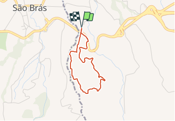
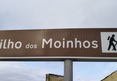
Randonnée Marche de 3,3 km à découvrir à Açores, Inconnu, Maia. Cette randonnée est proposée par vindju.
Description
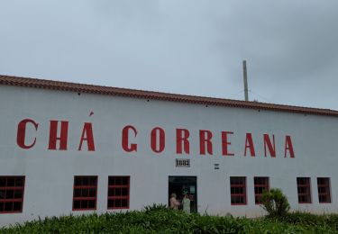
ette route circulaire le long des plantations de thé débute au parc de stationnement de la fabrique de thé Gorreana.
En fonctionnement depuis 1883, c’est la plus ancienne plantation de thé d’Europe. La plante utilisée — Camellia sinensis — pour la production de thé vert et de thé noir a été introduite dans l’île en 1750, transportée par les navires qui revenaient d’Orient.
Traversez avec précaution à la sortie de la fabrique vers le portail d’accès aux cultures de thé.
Prenez à gauche sur un chemin de terre qui monte, parallèle à la route, qui serpente dans la plantation, puis dans un bosquet de cryptomères (Cryptomeria japonica). Après avoir traversé un pont de pierre, les pâturages commencent à prendre la place du thé et des arbres. Vous trouverez quelques terrains de culture, des maisons d’appui à l’activité agricole et les dernières plantations de thé. Profitez de ce point élevé du parcours pour apprécier la vue sur la côte nord de l’île.
En suivant les indications, abandonnez le chemin principal, qui continue à monter à gauche, et prenez un sentier de terre étroit qui descend. Ce chemin, utilisé à l’époque des cueillettes par les ouvriers de la fabrique, descend entre les plantations, jusqu’à la fabrique du thé où prend fin le parcours.
Une fois à l’intérieur de la fabrique, profitez-en pour vous reposer, goûter un thé et en apprendre plus sur sa culture dans l’île, et sur les divers processus et techniques liés à sa production.
Localisation
Commentaires
Randonnées à proximité
![Randonnée A pied Maia - PRC36SMI Pedra Queimada - Lajinha - Degredo - Photo](https://media.geolcdn.com/t/375/260/82fef8b6-934c-4ba6-8ffd-ec02151b3df6.jpeg&format=jpg&maxdim=2)
![A pied A pied](https://static1.geolcdn.com/sitytour/trail-icons/100.png)
A pied
![](/images/other/stat-length.png)
![](https://static1.geolcdn.com/siteimages/upload/files/16400158638029165_repeat_loop_refresh_sync_direction_icon.png)
![Randonnée A pied Maia - PR27SMI Praia da Viola - Photo](https://media.geolcdn.com/t/375/260/ed7c9f2a-d6e1-474f-bdcd-6a16b106db9a.jpeg&format=jpg&maxdim=2)
![A pied A pied](https://static1.geolcdn.com/sitytour/trail-icons/100.png)
A pied
![](/images/other/stat-length.png)
![](https://static1.geolcdn.com/siteimages/upload/files/16400158638029165_repeat_loop_refresh_sync_direction_icon.png)
![Randonnée A pied Maia - PRC28SMI Chá Gorreana - Photo](https://media.geolcdn.com/t/375/260/4a44306d-4afd-4c2e-b0d0-2551521fe9f3.jpeg&format=jpg&maxdim=2)
![A pied A pied](https://static1.geolcdn.com/sitytour/trail-icons/100.png)
A pied
![](/images/other/stat-length.png)
![](https://static1.geolcdn.com/siteimages/upload/files/16400158638029165_repeat_loop_refresh_sync_direction_icon.png)
![Randonnée Marche Fenais da Ajuda - Moulins_de_RIBEIRA_jusque_Maia_7kmD220+440- - Photo](https://media.geolcdn.com/t/375/260/c5fa97c7-67fd-4a7c-88e7-64f18c8b8208.jpg&format=jpg&maxdim=2)
![Marche Marche](https://static1.geolcdn.com/sitytour/trail-icons/101.png)
Marche
![](/images/other/stat-length.png)
![](https://static1.geolcdn.com/siteimages/upload/files/16400158638029165_repeat_loop_refresh_sync_direction_icon.png)
![Randonnée Marche Maia - Chà Gorreana - Photo](https://media.geolcdn.com/t/375/260/f831a81b-f1ae-41ef-90e9-615656933ab7.jpg&format=jpg&maxdim=2)
![Marche Marche](https://static1.geolcdn.com/sitytour/trail-icons/101.png)
![Randonnée Marche Fenais da Ajuda - moinhos da ribeira funda prc35smi 3854 - Photo](https://media.geolcdn.com/t/375/260/ext.jpg?maxdim=2&url=https%3A%2F%2Fstatic1.geolcdn.com%2Fsiteimages%2Fupload%2Ffiles%2F1553511878bg_sport_marche.png)
![Marche Marche](https://static1.geolcdn.com/sitytour/trail-icons/101.png)
Marche
![](/images/other/stat-length.png)
![](https://static1.geolcdn.com/siteimages/upload/files/16400158638029165_repeat_loop_refresh_sync_direction_icon.png)
![Randonnée Marche Porto Formoso - São Miguel-Pico da Vela - Photo](https://media.geolcdn.com/t/375/260/ext.jpg?maxdim=2&url=https%3A%2F%2Fstatic1.geolcdn.com%2Fsiteimages%2Fupload%2Ffiles%2F1553511878bg_sport_marche.png)
![Marche Marche](https://static1.geolcdn.com/sitytour/trail-icons/101.png)
Marche
![](/images/other/stat-length.png)
![](https://static1.geolcdn.com/siteimages/upload/files/16400158638029165_repeat_loop_refresh_sync_direction_icon.png)
![Randonnée Marche Maia - 20230720acores - Photo](https://media.geolcdn.com/t/375/260/ext.jpg?maxdim=2&url=https%3A%2F%2Fstatic1.geolcdn.com%2Fsiteimages%2Fupload%2Ffiles%2F1553511878bg_sport_marche.png)
![Marche Marche](https://static1.geolcdn.com/sitytour/trail-icons/101.png)
![Randonnée sport Fenais da Ajuda - prc35smi-3854 - Photo](https://media.geolcdn.com/t/375/260/ext.jpg?maxdim=2&url=https%3A%2F%2Fsecurestorage.geolives.com%2Fsitytour%2Ftrail-bg%2Fdefault.jpg)
sport
![](/images/other/stat-length.png)
![](https://static1.geolcdn.com/siteimages/upload/files/16400158638029165_repeat_loop_refresh_sync_direction_icon.png)