![](/images/other/stat-length.png)
![Randonnée Marche Furnas - acores prc6smi 2960 lagoa de furnas - Photo](https://media.geolcdn.com/t/1900/400/ext.pjpeg?maxdim=2&url=https%3A%2F%2Fstatic1.geolcdn.com%2Fsiteimages%2Fupload%2Ffiles%2F1553511878bg_sport_marche.png)
acores prc6smi 2960 lagoa de furnas
vindju
Utilisateur
![Longueur](/images/other/stat-length.png)
![Altitude max](https://static1.geolcdn.com/siteimages/upload/files/1508320355ic_sort_altitude_max_24dp.png)
![Dénivelé positif](https://static1.geolcdn.com/siteimages/upload/files/1508320355ic_sort_den_pos_24dp.png)
![Km-Effort](/images/other/stat-length.png)
![Altitude min](https://static1.geolcdn.com/siteimages/upload/files/1508320355ic_sort_altitude_min_24dp.png)
![Dénivelé négatif](https://static1.geolcdn.com/siteimages/upload/files/1508320355ic_sort_den_neg_24dp.png)
![Boucle](https://static1.geolcdn.com/siteimages/upload/files/16400158638029165_repeat_loop_refresh_sync_direction_icon.png)
![Marche](https://static1.geolcdn.com/sitytour/trail-icons/101.png)
2h48
Difficulté : Facile
![Scannez ce code QR pour ouvrir la randonnée dans l'application SityTrail](https://capi.geolives.com/qq0zvz2zws4bq2lad0pu/sitytour/trails/821461/qr.png?size=200)
Application GPS de randonnée GRATUITE
À propos
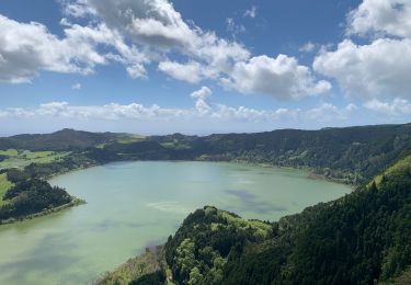
Randonnée Marche de 9,5 km à découvrir à Açores, Inconnu, Furnas. Cette randonnée est proposée par vindju.
Description
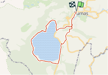
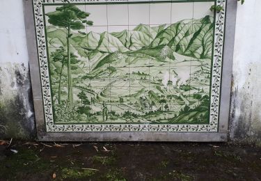
Ce parcours débute et s'achève dans la municipalité de Furnas, il dure environ 3 h.
Le parcours débute à Três Bicas et passe dans la localité pour commencer ensuite à monter par une route goudronnée qui donne accès à la lagune de Furnas.
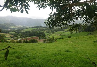
En suivant attentivement la signalétique, vous arriverez aux Caldeiras da Lagoa, environ 2,5 km après le début du parcours. On rencontre fréquemment dans cette zone des touristes observant les habitants locaux qui profitent de la température élevée du soleil pour élaborer des plats traditionnels.
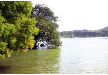
Le parcours se poursuit toujours le long de la lagune, il la contourne par un chemin en terre battue très accessible. Après avoir parcouru environ 3 km, vous rencontrerez la Chapelle de style Gothique Nossa Senhora das Vitórias, construite au XIXe siècle.
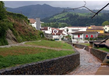
Continuez ensuite sur le bas-côté de la route régionale pavée sur environ 1,5 km jusqu'à rencontrer une déviation à votre droite qui descend vers la municipalité de Furnas. En suivant en permanence ce chemin, vous arriverez à la fin du parcours environ 30 mn plus tard.
Localisation
Commentaires
Randonnées à proximité
![Randonnée A pied Ribeira Quente - PR12SMI Agrião - Photo](https://media.geolcdn.com/t/375/260/4fa09008-ef7c-491e-8281-6f91d9fb5234.jpeg&format=jpg&maxdim=2)
![A pied A pied](https://static1.geolcdn.com/sitytour/trail-icons/100.png)
A pied
![](/images/other/stat-length.png)
![](https://static1.geolcdn.com/siteimages/upload/files/16400158638029165_repeat_loop_refresh_sync_direction_icon.png)
![Randonnée A pied Furnas - PR22SMI Grená - Pico do Ferro - Photo](https://media.geolcdn.com/t/375/260/ca82217c-4c0a-4a4d-9eed-6604d7ab69d2.jpeg&format=jpg&maxdim=2)
![A pied A pied](https://static1.geolcdn.com/sitytour/trail-icons/100.png)
A pied
![](/images/other/stat-length.png)
![](https://static1.geolcdn.com/siteimages/upload/files/16400158638029165_repeat_loop_refresh_sync_direction_icon.png)
![Randonnée A pied Furnas - PRC6SMI Lagoa das Furnas - Photo](https://media.geolcdn.com/t/375/260/9b175c11-5051-434e-94f0-5c3a83515708.jpeg&format=jpg&maxdim=2)
![A pied A pied](https://static1.geolcdn.com/sitytour/trail-icons/100.png)
A pied
![](/images/other/stat-length.png)
![](https://static1.geolcdn.com/siteimages/upload/files/16400158638029165_repeat_loop_refresh_sync_direction_icon.png)
![Randonnée Marche Furnas - 20230618sanmiguel - Photo](https://media.geolcdn.com/t/375/260/a9fbfba5-6d85-422a-9c5d-0a175b7e1040.jpg&format=jpg&maxdim=2)
![Marche Marche](https://static1.geolcdn.com/sitytour/trail-icons/101.png)
Marche
![](/images/other/stat-length.png)
![](https://static1.geolcdn.com/siteimages/upload/files/16400158638029165_repeat_loop_refresh_sync_direction_icon.png)
![Randonnée Marche Furnas - pico et lac furnas - Photo](https://media.geolcdn.com/t/375/260/0b919ad4-0c4a-4817-8a14-d10a7a3f0eac.jpg&format=jpg&maxdim=2)
![Marche Marche](https://static1.geolcdn.com/sitytour/trail-icons/101.png)
Marche
![](/images/other/stat-length.png)
![](https://static1.geolcdn.com/siteimages/upload/files/16400158638029165_repeat_loop_refresh_sync_direction_icon.png)
![Randonnée Marche Furnas - Grena Pico do ferro - Photo](https://media.geolcdn.com/t/375/260/ext.jpg?maxdim=2&url=https%3A%2F%2Fstatic1.geolcdn.com%2Fsiteimages%2Fupload%2Ffiles%2F1553511878bg_sport_marche.png)
![Marche Marche](https://static1.geolcdn.com/sitytour/trail-icons/101.png)
Marche
![](/images/other/stat-length.png)
![](https://static1.geolcdn.com/siteimages/upload/files/16400158638029165_repeat_loop_refresh_sync_direction_icon.png)
![Randonnée Marche Ribeira Quente - São Miguel-Trilho do Agriao - Photo](https://media.geolcdn.com/t/375/260/ext.jpg?maxdim=2&url=https%3A%2F%2Fstatic1.geolcdn.com%2Fsiteimages%2Fupload%2Ffiles%2F1553511878bg_sport_marche.png)
![Marche Marche](https://static1.geolcdn.com/sitytour/trail-icons/101.png)
Marche
![](/images/other/stat-length.png)
![](https://static1.geolcdn.com/siteimages/upload/files/16400158638029165_repeat_loop_refresh_sync_direction_icon.png)
![Randonnée Marche Furnas - Sao Miguel-Lagoa das Furnas - Photo](https://media.geolcdn.com/t/375/260/ext.jpg?maxdim=2&url=https%3A%2F%2Fstatic1.geolcdn.com%2Fsiteimages%2Fupload%2Ffiles%2F1553511878bg_sport_marche.png)
![Marche Marche](https://static1.geolcdn.com/sitytour/trail-icons/101.png)
Marche
![](/images/other/stat-length.png)
![](https://static1.geolcdn.com/siteimages/upload/files/16400158638029165_repeat_loop_refresh_sync_direction_icon.png)
![Randonnée Marche Furnas - Pico Furnas - Photo](https://media.geolcdn.com/t/375/260/6762eb60-2146-4413-8034-61425bb34048.jpg&format=jpg&maxdim=2)
![Marche Marche](https://static1.geolcdn.com/sitytour/trail-icons/101.png)