![](/images/other/stat-length.png)
![Randonnée V.T.T. Chinon - LE DOUBLE HUIT DE CHARLES - Photo](https://media.geolcdn.com/t/1900/400/ext.pjpeg?maxdim=2&url=https%3A%2F%2Fstatic1.geolcdn.com%2Fsiteimages%2Fupload%2Ffiles%2F1524743154velo.jpg)
LE DOUBLE HUIT DE CHARLES
laoj
Utilisateur
![Longueur](/images/other/stat-length.png)
Longueur
14,9 km
![Altitude max](https://static1.geolcdn.com/siteimages/upload/files/1508320355ic_sort_altitude_max_24dp.png)
Altitude max
129 m
![Dénivelé positif](https://static1.geolcdn.com/siteimages/upload/files/1508320355ic_sort_den_pos_24dp.png)
Dénivelé positif
215 m
![Km-Effort](/images/other/stat-length.png)
Km-Effort
17,7 km
![Altitude min](https://static1.geolcdn.com/siteimages/upload/files/1508320355ic_sort_altitude_min_24dp.png)
Altitude min
62 m
![Dénivelé négatif](https://static1.geolcdn.com/siteimages/upload/files/1508320355ic_sort_den_neg_24dp.png)
Dénivelé négatif
217 m
![Boucle](https://static1.geolcdn.com/siteimages/upload/files/16400158638029165_repeat_loop_refresh_sync_direction_icon.png)
Boucle
Oui
Date de création :
2017-08-29 00:00:00.0
Dernière modification :
2017-08-29 00:00:00.0
![V.T.T.](https://static1.geolcdn.com/sitytour/trail-icons/202.png)
1h10
Difficulté : Facile
![Scannez ce code QR pour ouvrir la randonnée dans l'application SityTrail](https://capi.geolives.com/qq0zvz2zws4bq2lad0pu/sitytour/trails/819761/qr.png?size=200)
Application GPS de randonnée GRATUITE
À propos
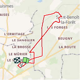
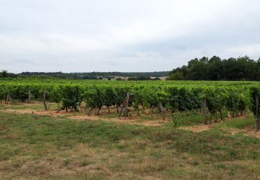
Randonnée V.T.T. de 14,9 km à découvrir à Centre-Val de Loire, Indre-et-Loire, Chinon. Cette randonnée est proposée par laoj.
Description
Ballade VTT en Forêt depuis le blanc carroi, le tracé suit principalement le GR3 pour aller à St benoit la forêt et au retour les routes forestières du bois de VILLIERS.
Localisation
Pays :
France
Région :
Centre-Val de Loire
Département/Province :
Indre-et-Loire
Commune :
Chinon
Localité :
Unknown
Départ:(Dec)
Départ:(UTM)
293222 ; 5229384 (31T) N.
Commentaires
Randonnées à proximité
![Randonnée Marche Saint-Benoît-la-Forêt - Saint-Benoît-la-Forêt - GR3 PR - 15.1km 205m 3h50 - 2022 07 14 - Photo](https://media.geolcdn.com/t/375/260/61ff6cf6-562d-4306-8540-da4739c253ed.jpg&format=jpg&maxdim=2)
![Marche Marche](https://static1.geolcdn.com/sitytour/trail-icons/101.png)
Saint-Benoît-la-Forêt - GR3 PR - 15.1km 205m 3h50 - 2022 07 14
Marche
Facile
(1)
Saint-Benoît-la-Forêt,
Centre-Val de Loire,
Indre-et-Loire,
France
![](/images/other/stat-length.png)
15,1 km | 17,8 km-effort
3h 50min
![](https://static1.geolcdn.com/siteimages/upload/files/16400158638029165_repeat_loop_refresh_sync_direction_icon.png)
Oui
![Randonnée Marche Rivière - Rivière - circuit Entre Vienne et vignes - 13km 120m 3h10 (35mn) - 2017 07 14 - Photo](https://media.geolcdn.com/t/375/260/3257858e-a22b-438d-bbd4-cdccba4b7589.jpg&format=jpg&maxdim=2)
![Marche Marche](https://static1.geolcdn.com/sitytour/trail-icons/101.png)
Rivière - circuit Entre Vienne et vignes - 13km 120m 3h10 (35mn) - 2017 07 14
Marche
Facile
(1)
Rivière,
Centre-Val de Loire,
Indre-et-Loire,
France
![](/images/other/stat-length.png)
13,1 km | 14,7 km-effort
3h 10min
![](https://static1.geolcdn.com/siteimages/upload/files/16400158638029165_repeat_loop_refresh_sync_direction_icon.png)
Oui
![Randonnée Marche Chinon - Parilly - Zig zag Ligré - 24.4km 330m 5h30 (50mn) - 2024 05 24 - Photo](https://media.geolcdn.com/t/375/260/35fa2308-066d-4120-b6d6-7b0ed77a89ee.jpg&format=jpg&maxdim=2)
![Marche Marche](https://static1.geolcdn.com/sitytour/trail-icons/101.png)
Parilly - Zig zag Ligré - 24.4km 330m 5h30 (50mn) - 2024 05 24
Marche
Facile
Chinon,
Centre-Val de Loire,
Indre-et-Loire,
France
![](/images/other/stat-length.png)
24 km | 29 km-effort
5h 30min
![](https://static1.geolcdn.com/siteimages/upload/files/16400158638029165_repeat_loop_refresh_sync_direction_icon.png)
Oui
![Randonnée Marche Chinon - Chinon - Zig zag Cravant-les-Côteaux GR48 GR3 - 22.4km 415m 5h05 (1h) - 2024 05 10 - Photo](https://media.geolcdn.com/t/375/260/ae5fec4c-f818-4ccd-8591-57df5497ff4a.jpg&format=jpg&maxdim=2)
![Marche Marche](https://static1.geolcdn.com/sitytour/trail-icons/101.png)
Chinon - Zig zag Cravant-les-Côteaux GR48 GR3 - 22.4km 415m 5h05 (1h) - 2024 ...
Marche
Moyen
Chinon,
Centre-Val de Loire,
Indre-et-Loire,
France
![](/images/other/stat-length.png)
22 km | 28 km-effort
5h 5min
![](https://static1.geolcdn.com/siteimages/upload/files/16400158638029165_repeat_loop_refresh_sync_direction_icon.png)
Oui
![Randonnée Marche Chinon - Chinon - Circuit Entre Puys du Chinonais et Vienne avec variante - 17.4km 240m 4h00 (25mn) - 2022 09 09 - Photo](https://media.geolcdn.com/t/375/260/6b30d929-af33-42af-8a5e-4de88435f728.jpg&format=jpg&maxdim=2)
![Marche Marche](https://static1.geolcdn.com/sitytour/trail-icons/101.png)
Chinon - Circuit Entre Puys du Chinonais et Vienne avec variante - 17.4km 240...
Marche
Moyen
Chinon,
Centre-Val de Loire,
Indre-et-Loire,
France
![](/images/other/stat-length.png)
17,4 km | 21 km-effort
4h 0min
![](https://static1.geolcdn.com/siteimages/upload/files/16400158638029165_repeat_loop_refresh_sync_direction_icon.png)
Oui
![Randonnée Marche Huismes - Huismes - les Fontaines d'Ozon GR3 - 15.9km 170m 3h35 - 2022 07 17 - Photo](https://media.geolcdn.com/t/375/260/1ba8f622-118c-4f2d-842d-ac374ba0c8ec.jpg&format=jpg&maxdim=2)
![Marche Marche](https://static1.geolcdn.com/sitytour/trail-icons/101.png)
Huismes - les Fontaines d'Ozon GR3 - 15.9km 170m 3h35 - 2022 07 17
Marche
Facile
Huismes,
Centre-Val de Loire,
Indre-et-Loire,
France
![](/images/other/stat-length.png)
15,9 km | 18,2 km-effort
3h 35min
![](https://static1.geolcdn.com/siteimages/upload/files/16400158638029165_repeat_loop_refresh_sync_direction_icon.png)
Oui
![Randonnée Marche Chinon - Rumba à Chinon - Photo](https://media.geolcdn.com/t/375/260/f1e05612-899a-4fb9-b616-6059167d20e8.jpg&format=jpg&maxdim=2)
![Marche Marche](https://static1.geolcdn.com/sitytour/trail-icons/101.png)
Rumba à Chinon
Marche
Facile
Chinon,
Centre-Val de Loire,
Indre-et-Loire,
France
![](/images/other/stat-length.png)
4,4 km | 5,4 km-effort
1h 52min
![](https://static1.geolcdn.com/siteimages/upload/files/16400158638029165_repeat_loop_refresh_sync_direction_icon.png)
Oui
![Randonnée Marche Beaumont-en-Véron - puys du chinonais - Photo](https://media.geolcdn.com/t/375/260/df213ae3-5822-4121-8ba6-770ef7a67dfd.jpg&format=jpg&maxdim=2)
![Marche Marche](https://static1.geolcdn.com/sitytour/trail-icons/101.png)
puys du chinonais
Marche
Moyen
Beaumont-en-Véron,
Centre-Val de Loire,
Indre-et-Loire,
France
![](/images/other/stat-length.png)
14,9 km | 17,4 km-effort
2h 21min
![](https://static1.geolcdn.com/siteimages/upload/files/16400158638029165_repeat_loop_refresh_sync_direction_icon.png)
Oui
![Randonnée V.T.T. Chinon - De Chinon à Saint Benoit la Forêt - Photo](https://media.geolcdn.com/t/375/260/ext.jpg?maxdim=2&url=https%3A%2F%2Fservices.sitytrail.com%2FGeolivesWS%2FDownloadMedia.ashx%3FTrailID%3D101416%26Media%3D1377_1.jpg)
![V.T.T. V.T.T.](https://static1.geolcdn.com/sitytour/trail-icons/202.png)
De Chinon à Saint Benoit la Forêt
V.T.T.
Difficile
Chinon,
Centre-Val de Loire,
Indre-et-Loire,
France
![](/images/other/stat-length.png)
41 km | 47 km-effort
3h 0min
![](https://static1.geolcdn.com/siteimages/upload/files/16400158638029165_repeat_loop_refresh_sync_direction_icon.png)
Oui