![](/images/other/stat-length.png)
![Randonnée Marche Monceaux-sur-Dordogne - Monceaux/Dordogne les 2 puys - Photo](https://media.geolcdn.com/t/1900/400/ext.pjpeg?maxdim=2&url=https%3A%2F%2Fstatic1.geolcdn.com%2Fsiteimages%2Fupload%2Ffiles%2F1553511878bg_sport_marche.png)
Monceaux/Dordogne les 2 puys
grageot
Utilisateur
![Longueur](/images/other/stat-length.png)
Longueur
14,3 km
![Altitude max](https://static1.geolcdn.com/siteimages/upload/files/1508320355ic_sort_altitude_max_24dp.png)
Altitude max
467 m
![Dénivelé positif](https://static1.geolcdn.com/siteimages/upload/files/1508320355ic_sort_den_pos_24dp.png)
Dénivelé positif
540 m
![Km-Effort](/images/other/stat-length.png)
Km-Effort
22 km
![Altitude min](https://static1.geolcdn.com/siteimages/upload/files/1508320355ic_sort_altitude_min_24dp.png)
Altitude min
180 m
![Dénivelé négatif](https://static1.geolcdn.com/siteimages/upload/files/1508320355ic_sort_den_neg_24dp.png)
Dénivelé négatif
543 m
![Boucle](https://static1.geolcdn.com/siteimages/upload/files/16400158638029165_repeat_loop_refresh_sync_direction_icon.png)
Boucle
Oui
Date de création :
2017-08-28 00:00:00.0
Dernière modification :
2017-08-28 00:00:00.0
![Marche](https://static1.geolcdn.com/sitytour/trail-icons/101.png)
4h45
Difficulté : Moyen
![Scannez ce code QR pour ouvrir la randonnée dans l'application SityTrail](https://capi.geolives.com/qq0zvz2zws4bq2lad0pu/sitytour/trails/819000/qr.png?size=200)
Application GPS de randonnée GRATUITE
À propos
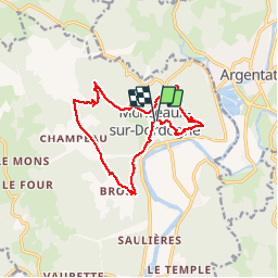
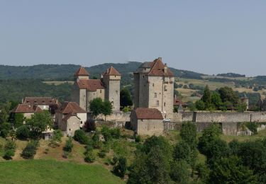
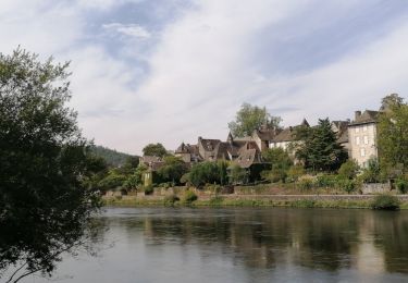
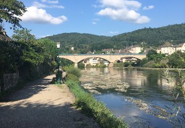
Randonnée Marche de 14,3 km à découvrir à Nouvelle-Aquitaine, Corrèze, Monceaux-sur-Dordogne. Cette randonnée est proposée par grageot.
Description
Une superbe randonnée proposée par le CD de la Corréze. Essentiellement sur chemins en sous-bois (idéal s'il fait chaud). Beaux panoramas sur la boucle de la Dordogne. Le gpx proposé par le site officiel n'est pas précis et plein d'erreurs.
Localisation
Pays :
France
Région :
Nouvelle-Aquitaine
Département/Province :
Corrèze
Commune :
Monceaux-sur-Dordogne
Localité :
Unknown
Départ:(Dec)
Départ:(UTM)
414073 ; 4992620 (31T) N.
Commentaires
Randonnées à proximité
![Randonnée Moto Argentat-sur-Dordogne - Les tours de Merle - Beaulieu - Collonges - Photo](https://media.geolcdn.com/t/375/260/44c653b0-1630-472d-bffc-dbc0f8dc05c5.jpg&format=jpg&maxdim=2)
![Moto Moto](https://static1.geolcdn.com/sitytour/trail-icons/402.png)
Les tours de Merle - Beaulieu - Collonges
Moto
Facile
Argentat-sur-Dordogne,
Nouvelle-Aquitaine,
Corrèze,
France
![](/images/other/stat-length.png)
162 km | 204 km-effort
4h 0min
![](https://static1.geolcdn.com/siteimages/upload/files/16400158638029165_repeat_loop_refresh_sync_direction_icon.png)
Non
![Randonnée sport Monceaux-sur-Dordogne - Monceaux sur Dordogne - Photo](https://media.geolcdn.com/t/375/260/510554c1-fb9d-4b2e-8478-cbf7688f12a6.jpg&format=jpg&maxdim=2)
Monceaux sur Dordogne
sport
Très facile
Monceaux-sur-Dordogne,
Nouvelle-Aquitaine,
Corrèze,
France
![](/images/other/stat-length.png)
5,2 km | 8,2 km-effort
Inconnu
![](https://static1.geolcdn.com/siteimages/upload/files/16400158638029165_repeat_loop_refresh_sync_direction_icon.png)
Oui
![Randonnée Cyclotourisme Bassignac-le-Bas - Beaulieu sur Dordogne-Argentat - Photo](https://media.geolcdn.com/t/375/260/c2e52cbf-3ae6-478f-a8f5-b23e0c3b0088.jpg&format=jpg&maxdim=2)
![Cyclotourisme Cyclotourisme](https://static1.geolcdn.com/sitytour/trail-icons/204.png)
Beaulieu sur Dordogne-Argentat
Cyclotourisme
Moyen
Bassignac-le-Bas,
Nouvelle-Aquitaine,
Corrèze,
France
![](/images/other/stat-length.png)
32 km | 38 km-effort
2h 27min
![](https://static1.geolcdn.com/siteimages/upload/files/16400158638029165_repeat_loop_refresh_sync_direction_icon.png)
Non
![Randonnée Marche Argentat-sur-Dordogne - argentât - Photo](https://media.geolcdn.com/t/375/260/1d232f8b-5b0a-4d9f-8afa-84c5312be241.jpg&format=jpg&maxdim=2)
![Marche Marche](https://static1.geolcdn.com/sitytour/trail-icons/101.png)
argentât
Marche
Très facile
Argentat-sur-Dordogne,
Nouvelle-Aquitaine,
Corrèze,
France
![](/images/other/stat-length.png)
8,5 km | 10,3 km-effort
3h 57min
![](https://static1.geolcdn.com/siteimages/upload/files/16400158638029165_repeat_loop_refresh_sync_direction_icon.png)
Non
![Randonnée Autre activité Monceaux-sur-Dordogne - De Bros à Argentat - Photo](https://media.geolcdn.com/t/375/260/ext.jpg?maxdim=2&url=https%3A%2F%2Fservices.sitytrail.com%2FGeolivesWS%2FDownloadMedia.ashx%3FTrailID%3D801939%26Media%3D20170803180521.jpg)
![Autre activité Autre activité](https://static1.geolcdn.com/sitytour/trail-icons/900.png)
De Bros à Argentat
Autre activité
Moyen
Monceaux-sur-Dordogne,
Nouvelle-Aquitaine,
Corrèze,
France
![](/images/other/stat-length.png)
8,7 km | 12,5 km-effort
2h 15min
![](https://static1.geolcdn.com/siteimages/upload/files/16400158638029165_repeat_loop_refresh_sync_direction_icon.png)
Non
![Randonnée Marche Saint-Chamant - L'école buissonnière à St Chamant - Photo](https://media.geolcdn.com/t/375/260/ext.jpg?maxdim=2&url=https%3A%2F%2Fstatic1.geolcdn.com%2Fsiteimages%2Fupload%2Ffiles%2F1553511878bg_sport_marche.png)
![Marche Marche](https://static1.geolcdn.com/sitytour/trail-icons/101.png)
L'école buissonnière à St Chamant
Marche
Difficile
Saint-Chamant,
Nouvelle-Aquitaine,
Corrèze,
France
![](/images/other/stat-length.png)
10,3 km | 15,5 km-effort
3h 31min
![](https://static1.geolcdn.com/siteimages/upload/files/16400158638029165_repeat_loop_refresh_sync_direction_icon.png)
Oui
![Randonnée V.T.T. Argentat-sur-Dordogne - Tour de la Xaintrie Noire (Corrèze) (en 2021) - Photo](https://media.geolcdn.com/t/375/260/ext.jpg?maxdim=2&url=https%3A%2F%2Fstatic1.geolcdn.com%2Fsiteimages%2Fupload%2Ffiles%2F1524743154velo.jpg)
![V.T.T. V.T.T.](https://static1.geolcdn.com/sitytour/trail-icons/202.png)
Tour de la Xaintrie Noire (Corrèze) (en 2021)
V.T.T.
Très difficile
Argentat-sur-Dordogne,
Nouvelle-Aquitaine,
Corrèze,
France
![](/images/other/stat-length.png)
61 km | 83 km-effort
5h 44min
![](https://static1.geolcdn.com/siteimages/upload/files/16400158638029165_repeat_loop_refresh_sync_direction_icon.png)
Oui
![Randonnée Marche La Chapelle-Saint-Géraud - la chappelle Saint Geraud - Photo](https://media.geolcdn.com/t/375/260/ext.jpg?maxdim=2&url=https%3A%2F%2Fstatic1.geolcdn.com%2Fsiteimages%2Fupload%2Ffiles%2F1553511878bg_sport_marche.png)
![Marche Marche](https://static1.geolcdn.com/sitytour/trail-icons/101.png)
la chappelle Saint Geraud
Marche
Moyen
(1)
La Chapelle-Saint-Géraud,
Nouvelle-Aquitaine,
Corrèze,
France
![](/images/other/stat-length.png)
5,7 km | 7,9 km-effort
1h 53min
![](https://static1.geolcdn.com/siteimages/upload/files/16400158638029165_repeat_loop_refresh_sync_direction_icon.png)
Oui
![Randonnée Marche Argentat-sur-Dordogne - Argentat - les crêtes - Photo](https://media.geolcdn.com/t/375/260/ext.jpg?maxdim=2&url=https%3A%2F%2Fstatic1.geolcdn.com%2Fsiteimages%2Fupload%2Ffiles%2F1553511878bg_sport_marche.png)
![Marche Marche](https://static1.geolcdn.com/sitytour/trail-icons/101.png)
Argentat - les crêtes
Marche
Moyen
Argentat-sur-Dordogne,
Nouvelle-Aquitaine,
Corrèze,
France
![](/images/other/stat-length.png)
9,7 km | 13,2 km-effort
2h 54min
![](https://static1.geolcdn.com/siteimages/upload/files/16400158638029165_repeat_loop_refresh_sync_direction_icon.png)
Oui