![](/images/other/stat-length.png)
![Randonnée Marche nordique Saint-Cyr-le-Chatoux - 69870StCyrChatoux-MarcheNordique-170827 - Photo](https://media.geolcdn.com/t/1900/400/ext.pjpeg?maxdim=2&url=https%3A%2F%2Fstatic1.geolcdn.com%2Fsiteimages%2Fupload%2Ffiles%2F1545311037marcheuse_200dpi.jpg)
69870StCyrChatoux-MarcheNordique-170827
adye
Utilisateur
![Longueur](/images/other/stat-length.png)
Longueur
12,3 km
![Altitude max](https://static1.geolcdn.com/siteimages/upload/files/1508320355ic_sort_altitude_max_24dp.png)
Altitude max
837 m
![Dénivelé positif](https://static1.geolcdn.com/siteimages/upload/files/1508320355ic_sort_den_pos_24dp.png)
Dénivelé positif
396 m
![Km-Effort](/images/other/stat-length.png)
Km-Effort
17,6 km
![Altitude min](https://static1.geolcdn.com/siteimages/upload/files/1508320355ic_sort_altitude_min_24dp.png)
Altitude min
582 m
![Dénivelé négatif](https://static1.geolcdn.com/siteimages/upload/files/1508320355ic_sort_den_neg_24dp.png)
Dénivelé négatif
395 m
![Boucle](https://static1.geolcdn.com/siteimages/upload/files/16400158638029165_repeat_loop_refresh_sync_direction_icon.png)
Boucle
Oui
Date de création :
2017-08-27 00:00:00.0
Dernière modification :
2017-08-27 00:00:00.0
![Marche nordique](https://static1.geolcdn.com/sitytour/trail-icons/102.png)
2h50
Difficulté : Moyen
![Scannez ce code QR pour ouvrir la randonnée dans l'application SityTrail](https://capi.geolives.com/qq0zvz2zws4bq2lad0pu/sitytour/trails/818394/qr.png?size=200)
Application GPS de randonnée GRATUITE
À propos
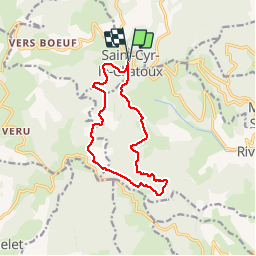
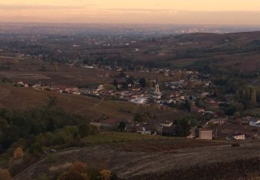
Randonnée Marche nordique de 12,3 km à découvrir à Auvergne-Rhône-Alpes, Rhône, Saint-Cyr-le-Chatoux. Cette randonnée est proposée par adye.
Description
Marche Nordique, 12 kms allure libre
par l'AZVEL (le 27/08/2017)
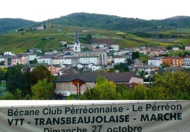
Départ/Arrivée : Saint-Cyr le Chatoux
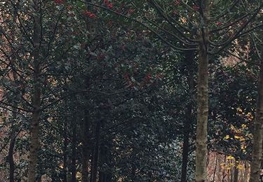
Forêt départementale de la Cantinière, Col du Joncin, carrière de Rivolet
Localisation
Pays :
France
Région :
Auvergne-Rhône-Alpes
Département/Province :
Rhône
Commune :
Saint-Cyr-le-Chatoux
Localité :
Unknown
Départ:(Dec)
Départ:(UTM)
620500 ; 5098235 (31T) N.
Commentaires
Randonnées à proximité
![Randonnée A pied Vaux-en-Beaujolais - Itinérant Beaujolais rouge étape 2 Le Flagolet - Odenas - Photo](https://media.geolcdn.com/t/375/260/e854eec2-8ed0-4512-9e04-68895c0881ec.jpg&format=jpg&maxdim=2)
![A pied A pied](https://static1.geolcdn.com/sitytour/trail-icons/100.png)
Itinérant Beaujolais rouge étape 2 Le Flagolet - Odenas
A pied
Très difficile
Vaux-en-Beaujolais,
Auvergne-Rhône-Alpes,
Rhône,
France
![](/images/other/stat-length.png)
22 km | 35 km-effort
7h 58min
![](https://static1.geolcdn.com/siteimages/upload/files/16400158638029165_repeat_loop_refresh_sync_direction_icon.png)
Non
![Randonnée Marche Montmelas-Saint-Sorlin - Col de Saint Bonnet (13-09-18) - Photo](https://media.geolcdn.com/t/375/260/ext.jpg?maxdim=2&url=https%3A%2F%2Fstatic1.geolcdn.com%2Fsiteimages%2Fupload%2Ffiles%2F1553511878bg_sport_marche.png)
![Marche Marche](https://static1.geolcdn.com/sitytour/trail-icons/101.png)
Col de Saint Bonnet (13-09-18)
Marche
Facile
(1)
Montmelas-Saint-Sorlin,
Auvergne-Rhône-Alpes,
Rhône,
France
![](/images/other/stat-length.png)
8,1 km | 11,9 km-effort
2h 29min
![](https://static1.geolcdn.com/siteimages/upload/files/16400158638029165_repeat_loop_refresh_sync_direction_icon.png)
Oui
![Randonnée Marche Saint-Cyr-le-Chatoux - Saint-cyr-le-Chatoux](https://media.geolcdn.com/t/375/260/ext.jpg?maxdim=2&url=https%3A%2F%2Fstatic1.geolcdn.com%2Fsiteimages%2Fupload%2Ffiles%2F1553511878bg_sport_marche.png)
![Marche Marche](https://static1.geolcdn.com/sitytour/trail-icons/101.png)
Saint-cyr-le-Chatoux "Les Agneaux"
Marche
Moyen
(2)
Saint-Cyr-le-Chatoux,
Auvergne-Rhône-Alpes,
Rhône,
France
![](/images/other/stat-length.png)
11,7 km | 16,7 km-effort
3h 45min
![](https://static1.geolcdn.com/siteimages/upload/files/16400158638029165_repeat_loop_refresh_sync_direction_icon.png)
Oui
![Randonnée Marche Rivolet - Rivolet - Photo](https://media.geolcdn.com/t/375/260/ext.jpg?maxdim=2&url=https%3A%2F%2Fstatic1.geolcdn.com%2Fsiteimages%2Fupload%2Ffiles%2F1553511878bg_sport_marche.png)
![Marche Marche](https://static1.geolcdn.com/sitytour/trail-icons/101.png)
Rivolet
Marche
Moyen
(2)
Rivolet,
Auvergne-Rhône-Alpes,
Rhône,
France
![](/images/other/stat-length.png)
11,1 km | 17,2 km-effort
3h 42min
![](https://static1.geolcdn.com/siteimages/upload/files/16400158638029165_repeat_loop_refresh_sync_direction_icon.png)
Non
![Randonnée Marche Vaux-en-Beaujolais - Vaulx en beaujolais - Photo](https://media.geolcdn.com/t/375/260/5d38e822-f001-465a-8b11-8660c8452a0b.jpg&format=jpg&maxdim=2)
![Marche Marche](https://static1.geolcdn.com/sitytour/trail-icons/101.png)
Vaulx en beaujolais
Marche
Facile
(1)
Vaux-en-Beaujolais,
Auvergne-Rhône-Alpes,
Rhône,
France
![](/images/other/stat-length.png)
14,3 km | 22 km-effort
4h 25min
![](https://static1.geolcdn.com/siteimages/upload/files/16400158638029165_repeat_loop_refresh_sync_direction_icon.png)
Oui
![Randonnée Marche Chamelet - Chamelet (69) 16,7 km via Chapelle de la Salette - Photo](https://media.geolcdn.com/t/375/260/ext.jpg?maxdim=2&url=https%3A%2F%2Fservices.sitytrail.com%2FGeolivesWS%2FDownloadMedia.ashx%3FTrailID%3D682289%26Media%3D20170109145907.jpg)
![Marche Marche](https://static1.geolcdn.com/sitytour/trail-icons/101.png)
Chamelet (69) 16,7 km via Chapelle de la Salette
Marche
Moyen
Chamelet,
Auvergne-Rhône-Alpes,
Rhône,
France
![](/images/other/stat-length.png)
16,6 km | 27 km-effort
5h 33min
![](https://static1.geolcdn.com/siteimages/upload/files/16400158638029165_repeat_loop_refresh_sync_direction_icon.png)
Oui
![Randonnée Marche Chamelet - Chamelet (69) 19,5 km D. 776 m - Photo](https://media.geolcdn.com/t/375/260/ext.jpg?maxdim=2&url=https%3A%2F%2Fservices.sitytrail.com%2FGeolivesWS%2FDownloadMedia.ashx%3FTrailID%3D664631%26Media%3D20161126105826.jpg)
![Marche Marche](https://static1.geolcdn.com/sitytour/trail-icons/101.png)
Chamelet (69) 19,5 km D. 776 m
Marche
Difficile
Chamelet,
Auvergne-Rhône-Alpes,
Rhône,
France
![](/images/other/stat-length.png)
19,3 km | 29 km-effort
6h 5min
![](https://static1.geolcdn.com/siteimages/upload/files/16400158638029165_repeat_loop_refresh_sync_direction_icon.png)
Oui
![Randonnée Marche Le Perréon - le Perréon (69) - Photo](https://media.geolcdn.com/t/375/260/ext.jpg?maxdim=2&url=https%3A%2F%2Fservices.sitytrail.com%2FGeolivesWS%2FDownloadMedia.ashx%3FTrailID%3D661414%26Media%3D20161117165057.jpg)
![Marche Marche](https://static1.geolcdn.com/sitytour/trail-icons/101.png)
le Perréon (69)
Marche
Facile
Le Perréon,
Auvergne-Rhône-Alpes,
Rhône,
France
![](/images/other/stat-length.png)
10,8 km | 16,5 km-effort
3h 17min
![](https://static1.geolcdn.com/siteimages/upload/files/16400158638029165_repeat_loop_refresh_sync_direction_icon.png)
Oui
![Randonnée V.T.T. Le Perréon - La 22ème Transbeaujolaise (2013-VTT-40km) - Le Perréon - Photo](https://media.geolcdn.com/t/375/260/ext.jpg?maxdim=2&url=https%3A%2F%2Fservices.sitytrail.com%2FGeolivesWS%2FDownloadMedia.ashx%3FTrailID%3D317162%26Media%3D16313_6.jpg)
![V.T.T. V.T.T.](https://static1.geolcdn.com/sitytour/trail-icons/202.png)
La 22ème Transbeaujolaise (2013-VTT-40km) - Le Perréon
V.T.T.
Difficile
Le Perréon,
Auvergne-Rhône-Alpes,
Rhône,
France
![](/images/other/stat-length.png)
37 km | 48 km-effort
4h 0min
![](https://static1.geolcdn.com/siteimages/upload/files/16400158638029165_repeat_loop_refresh_sync_direction_icon.png)
Oui