![](/images/other/stat-length.png)
![Randonnée Marche Bitschwiller-lès-Thann - 68 Hundsruck - FA du Gsang - Photo](https://media.geolcdn.com/t/1900/400/ext.pjpeg?maxdim=2&url=https%3A%2F%2Fstatic1.geolcdn.com%2Fsiteimages%2Fupload%2Ffiles%2F1553511878bg_sport_marche.png)
68 Hundsruck - FA du Gsang
E.BURCK
Utilisateur
![Longueur](/images/other/stat-length.png)
Longueur
12,3 km
![Altitude max](https://static1.geolcdn.com/siteimages/upload/files/1508320355ic_sort_altitude_max_24dp.png)
Altitude max
1174 m
![Dénivelé positif](https://static1.geolcdn.com/siteimages/upload/files/1508320355ic_sort_den_pos_24dp.png)
Dénivelé positif
664 m
![Km-Effort](/images/other/stat-length.png)
Km-Effort
21 km
![Altitude min](https://static1.geolcdn.com/siteimages/upload/files/1508320355ic_sort_altitude_min_24dp.png)
Altitude min
747 m
![Dénivelé négatif](https://static1.geolcdn.com/siteimages/upload/files/1508320355ic_sort_den_neg_24dp.png)
Dénivelé négatif
540 m
![Boucle](https://static1.geolcdn.com/siteimages/upload/files/16400158638029165_repeat_loop_refresh_sync_direction_icon.png)
Boucle
Non
Date de création :
2018-04-16 21:28:56.951
Dernière modification :
2019-12-17 14:23:10.594
![Marche](https://static1.geolcdn.com/sitytour/trail-icons/101.png)
3h53
Difficulté : Moyen
![Scannez ce code QR pour ouvrir la randonnée dans l'application SityTrail](https://capi.geolives.com/qq0zvz2zws4bq2lad0pu/sitytour/trails/815398/qr.png?size=200)
Application GPS de randonnée GRATUITE
À propos
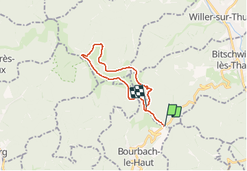
Randonnée Marche de 12,3 km à découvrir à Grand Est, Haut-Rhin, Bitschwiller-lès-Thann. Cette randonnée est proposée par E.BURCK.
Description
ACCÈS :
Par Bourbach le Haut ou par Thann.
PARKING:
Col du Hundsruck.
47.806391, 7.042633 ou
N 47°48'23", E 07°02'33"
RESTAURATION :
Ferme Auberge du Gsang. Tél: 03 89 38 96 85
Localisation
Pays :
France
Région :
Grand Est
Département/Province :
Haut-Rhin
Commune :
Bitschwiller-lès-Thann
Localité :
Unknown
Départ:(Dec)
Départ:(UTM)
353451 ; 5296660 (32T) N.
Commentaires
Randonnées à proximité
![Randonnée Marche Masevaux-Niederbruck - Masevaux - Rossberg par le belvédère du Fuchsfelsen - Photo](https://media.geolcdn.com/t/375/260/d9cc765c-1250-4953-9d9f-fb8b88eb82a7.jpg&format=jpg&maxdim=2)
![Marche Marche](https://static1.geolcdn.com/sitytour/trail-icons/101.png)
Masevaux - Rossberg par le belvédère du Fuchsfelsen
Marche
Moyen
(1)
Masevaux-Niederbruck,
Grand Est,
Haut-Rhin,
France
![](/images/other/stat-length.png)
19,9 km | 34 km-effort
4h 44min
![](https://static1.geolcdn.com/siteimages/upload/files/16400158638029165_repeat_loop_refresh_sync_direction_icon.png)
Oui
![Randonnée Marche Bourbach-le-Haut - Tour du Rossberg - Gsang - Thannerhubel - Photo](https://media.geolcdn.com/t/375/260/d4089ace-97e6-4d95-86a3-a999ece263d3.jpg&format=jpg&maxdim=2)
![Marche Marche](https://static1.geolcdn.com/sitytour/trail-icons/101.png)
Tour du Rossberg - Gsang - Thannerhubel
Marche
Difficile
Bourbach-le-Haut,
Grand Est,
Haut-Rhin,
France
![](/images/other/stat-length.png)
11,4 km | 18,5 km-effort
4h 12min
![](https://static1.geolcdn.com/siteimages/upload/files/16400158638029165_repeat_loop_refresh_sync_direction_icon.png)
Oui
![Randonnée Marche Thann - JD 14/20 Thann-roche--albert--grumbachkopf - Photo](https://media.geolcdn.com/t/375/260/ext.jpg?maxdim=2&url=https%3A%2F%2Fstatic1.geolcdn.com%2Fsiteimages%2Fupload%2Ffiles%2F1553511878bg_sport_marche.png)
![Marche Marche](https://static1.geolcdn.com/sitytour/trail-icons/101.png)
JD 14/20 Thann-roche--albert--grumbachkopf
Marche
Moyen
(1)
Thann,
Grand Est,
Haut-Rhin,
France
![](/images/other/stat-length.png)
7,6 km | 12 km-effort
2h 28min
![](https://static1.geolcdn.com/siteimages/upload/files/16400158638029165_repeat_loop_refresh_sync_direction_icon.png)
Oui
![Randonnée A pied Bitschwiller-lès-Thann - Bitschwiller les Thann - Rehbrunnel - Abri du Becherkopf - Roche Albert - Photo](https://media.geolcdn.com/t/375/260/ext.jpg?maxdim=2&url=https%3A%2F%2Fstatic1.geolcdn.com%2Fsiteimages%2Fupload%2Ffiles%2F1545311037marcheuse_200dpi.jpg)
![A pied A pied](https://static1.geolcdn.com/sitytour/trail-icons/100.png)
Bitschwiller les Thann - Rehbrunnel - Abri du Becherkopf - Roche Albert
A pied
Moyen
(1)
Bitschwiller-lès-Thann,
Grand Est,
Haut-Rhin,
France
![](/images/other/stat-length.png)
10,3 km | 16,4 km-effort
Inconnu
![](https://static1.geolcdn.com/siteimages/upload/files/16400158638029165_repeat_loop_refresh_sync_direction_icon.png)
Oui
![Randonnée Marche Bitschwiller-lès-Thann - 68 Col du Hundsrück - FA Gsang - retour ThannerHubel - Photo](https://media.geolcdn.com/t/375/260/ext.jpg?maxdim=2&url=https%3A%2F%2Fstatic1.geolcdn.com%2Fsiteimages%2Fupload%2Ffiles%2F1553511878bg_sport_marche.png)
![Marche Marche](https://static1.geolcdn.com/sitytour/trail-icons/101.png)
68 Col du Hundsrück - FA Gsang - retour ThannerHubel
Marche
Moyen
(1)
Bitschwiller-lès-Thann,
Grand Est,
Haut-Rhin,
France
![](/images/other/stat-length.png)
11,2 km | 18,4 km-effort
3h 48min
![](https://static1.geolcdn.com/siteimages/upload/files/16400158638029165_repeat_loop_refresh_sync_direction_icon.png)
Oui
![Randonnée Marche Thann - Entre Thann et le Molkenrain - Photo](https://media.geolcdn.com/t/375/260/288febbb-1400-419f-925a-b31a67c6a7df.jpg&format=jpg&maxdim=2)
![Marche Marche](https://static1.geolcdn.com/sitytour/trail-icons/101.png)
Entre Thann et le Molkenrain
Marche
Difficile
Thann,
Grand Est,
Haut-Rhin,
France
![](/images/other/stat-length.png)
24 km | 39 km-effort
8h 47min
![](https://static1.geolcdn.com/siteimages/upload/files/16400158638029165_repeat_loop_refresh_sync_direction_icon.png)
Oui
![Randonnée Vélo électrique Thann - Thann lac de Kruth - Photo](https://media.geolcdn.com/t/375/260/f55f8e20-2cc2-42d2-8acb-2cc22e065b5e.jpg&format=jpg&maxdim=2)
![Vélo électrique Vélo électrique](https://static1.geolcdn.com/sitytour/trail-icons/205.png)
Thann lac de Kruth
Vélo électrique
Moyen
Thann,
Grand Est,
Haut-Rhin,
France
![](/images/other/stat-length.png)
49 km | 58 km-effort
4h 2min
![](https://static1.geolcdn.com/siteimages/upload/files/16400158638029165_repeat_loop_refresh_sync_direction_icon.png)
Oui
![Randonnée Marche Masevaux-Niederbruck - Reco avec ALAIN..Rando CLAS du 29/08/2024 - Photo](https://media.geolcdn.com/t/375/260/5dba7985-af1b-4076-a275-05f9cb5145f8.jpg&format=jpg&maxdim=2)
![Marche Marche](https://static1.geolcdn.com/sitytour/trail-icons/101.png)
Reco avec ALAIN..Rando CLAS du 29/08/2024
Marche
Très difficile
Masevaux-Niederbruck,
Grand Est,
Haut-Rhin,
France
![](/images/other/stat-length.png)
20 km | 31 km-effort
6h 2min
![](https://static1.geolcdn.com/siteimages/upload/files/16400158638029165_repeat_loop_refresh_sync_direction_icon.png)
Oui
![Randonnée Marche Willer-sur-Thur - Willer sur Thur col du Haag - Photo](https://media.geolcdn.com/t/375/260/964ecb3f-37e6-4c86-a191-a0731846b89c.jpg&format=jpg&maxdim=2)
![Marche Marche](https://static1.geolcdn.com/sitytour/trail-icons/101.png)
Willer sur Thur col du Haag
Marche
Moyen
Willer-sur-Thur,
Grand Est,
Haut-Rhin,
France
![](/images/other/stat-length.png)
29 km | 46 km-effort
6h 45min
![](https://static1.geolcdn.com/siteimages/upload/files/16400158638029165_repeat_loop_refresh_sync_direction_icon.png)
Oui