![](/images/other/stat-length.png)
![Randonnée Marche Saint-Divy - Saint Divy, vers Malvézan - Photo](https://media.geolcdn.com/t/1900/400/ext.pjpeg?maxdim=2&url=https%3A%2F%2Fstatic1.geolcdn.com%2Fsiteimages%2Fupload%2Ffiles%2F1553511878bg_sport_marche.png)
Saint Divy, vers Malvézan
Balades en Finistère
Promenez-vous au bout du monde !
![Longueur](/images/other/stat-length.png)
Longueur
8,4 km
![Altitude max](https://static1.geolcdn.com/siteimages/upload/files/1508320355ic_sort_altitude_max_24dp.png)
Altitude max
127 m
![Dénivelé positif](https://static1.geolcdn.com/siteimages/upload/files/1508320355ic_sort_den_pos_24dp.png)
Dénivelé positif
112 m
![Km-Effort](/images/other/stat-length.png)
Km-Effort
9,9 km
![Altitude min](https://static1.geolcdn.com/siteimages/upload/files/1508320355ic_sort_altitude_min_24dp.png)
Altitude min
41 m
![Dénivelé négatif](https://static1.geolcdn.com/siteimages/upload/files/1508320355ic_sort_den_neg_24dp.png)
Dénivelé négatif
112 m
![Boucle](https://static1.geolcdn.com/siteimages/upload/files/16400158638029165_repeat_loop_refresh_sync_direction_icon.png)
Boucle
Oui
Date de création :
2018-07-06 09:45:40.362
Dernière modification :
2018-07-06 09:45:40.362
![Marche](https://static1.geolcdn.com/sitytour/trail-icons/101.png)
2h09
Difficulté : Facile
![Scannez ce code QR pour ouvrir la randonnée dans l'application SityTrail](https://capi.geolives.com/qq0zvz2zws4bq2lad0pu/sitytour/trails/815250/qr.png?size=200)
Application GPS de randonnée GRATUITE
À propos
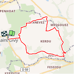
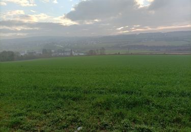
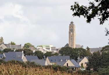
Randonnée Marche de 8,4 km à découvrir à Bretagne, Finistère, Saint-Divy. Cette randonnée est proposée par Balades en Finistère.
Description
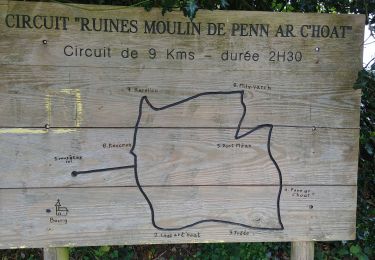
Au départ de Saint Divy, uneboucle vers l'est. Milin Var'h Malvezan Lostt ar C'hoat et retour
Localisation
Pays :
France
Région :
Bretagne
Département/Province :
Finistère
Commune :
Saint-Divy
Localité :
Unknown
Départ:(Dec)
Départ:(UTM)
401315 ; 5367626 (30U) N.
Commentaires
Randonnées à proximité
![Randonnée Marche Kersaint-Plabennec - Coulée verte a Kersaint-Plabennec - Photo](https://media.geolcdn.com/t/375/260/ext.jpg?maxdim=2&url=https%3A%2F%2Fservices.sitytrail.com%2FGeolivesWS%2FDownloadMedia.ashx%3FTrailID%3D210069%26Media%3Dfix__20130804140056.jpg)
![Marche Marche](https://static1.geolcdn.com/sitytour/trail-icons/101.png)
Coulée verte a Kersaint-Plabennec
Marche
Très facile
(1)
Kersaint-Plabennec,
Bretagne,
Finistère,
France
![](/images/other/stat-length.png)
2,6 km | 2,8 km-effort
58min
![](https://static1.geolcdn.com/siteimages/upload/files/16400158638029165_repeat_loop_refresh_sync_direction_icon.png)
Oui
![Randonnée Marche nordique Guipavas - hôtel cafe chantant st divi guipavas - Photo](https://media.geolcdn.com/t/375/260/1880b21b-949a-4788-b275-62329c398c0c.jpg&format=jpg&maxdim=2)
![Marche nordique Marche nordique](https://static1.geolcdn.com/sitytour/trail-icons/102.png)
hôtel cafe chantant st divi guipavas
Marche nordique
Très facile
Guipavas,
Bretagne,
Finistère,
France
![](/images/other/stat-length.png)
13 km | 15,1 km-effort
3h 14min
![](https://static1.geolcdn.com/siteimages/upload/files/16400158638029165_repeat_loop_refresh_sync_direction_icon.png)
Oui
![Randonnée Marche nordique Landerneau - landerneau forest landerneau - Photo](https://media.geolcdn.com/t/375/260/f381417f-2169-4c2d-be0f-4eb4cc64935c.jpg&format=jpg&maxdim=2)
![Marche nordique Marche nordique](https://static1.geolcdn.com/sitytour/trail-icons/102.png)
landerneau forest landerneau
Marche nordique
Très facile
Landerneau,
Bretagne,
Finistère,
France
![](/images/other/stat-length.png)
16,5 km | 19,4 km-effort
3h 40min
![](https://static1.geolcdn.com/siteimages/upload/files/16400158638029165_repeat_loop_refresh_sync_direction_icon.png)
Oui
![Randonnée Marche nordique La Forest-Landerneau - la forest landerneau vers landerneau - Photo](https://media.geolcdn.com/t/375/260/237d8cf2-b670-4b35-a1cb-46be9c0205cd.jpg&format=jpg&maxdim=2)
![Marche nordique Marche nordique](https://static1.geolcdn.com/sitytour/trail-icons/102.png)
la forest landerneau vers landerneau
Marche nordique
Très facile
La Forest-Landerneau,
Bretagne,
Finistère,
France
![](/images/other/stat-length.png)
7,5 km | 9,1 km-effort
1h 50min
![](https://static1.geolcdn.com/siteimages/upload/files/16400158638029165_repeat_loop_refresh_sync_direction_icon.png)
Oui
![Randonnée Marche Saint-Divy - Tour de Saint Divy Est - Photo](https://media.geolcdn.com/t/375/260/4a4d1382-92cd-4ed9-988f-584e62ec0b54.jpg&format=jpg&maxdim=2)
![Marche Marche](https://static1.geolcdn.com/sitytour/trail-icons/101.png)
Tour de Saint Divy Est
Marche
Très facile
Saint-Divy,
Bretagne,
Finistère,
France
![](/images/other/stat-length.png)
9,7 km | 11,3 km-effort
2h 2min
![](https://static1.geolcdn.com/siteimages/upload/files/16400158638029165_repeat_loop_refresh_sync_direction_icon.png)
Oui
![Randonnée Marche La Forest-Landerneau - PR Grand tour de la Forest-Landerneau - Photo](https://media.geolcdn.com/t/375/260/ext.jpg?maxdim=2&url=https%3A%2F%2Fservices.sitytrail.com%2FGeolivesWS%2FDownloadMedia.ashx%3FTrailID%3D857622%26Media%3Dfix__20171105152828.jpg)
![Marche Marche](https://static1.geolcdn.com/sitytour/trail-icons/101.png)
PR Grand tour de la Forest-Landerneau
Marche
Facile
La Forest-Landerneau,
Bretagne,
Finistère,
France
![](/images/other/stat-length.png)
10,8 km | 13,2 km-effort
1h 56min
![](https://static1.geolcdn.com/siteimages/upload/files/16400158638029165_repeat_loop_refresh_sync_direction_icon.png)
Oui
![Randonnée Cheval Guipavas - De Gupavas à la Forêt de Landerneau - Photo](https://media.geolcdn.com/t/375/260/ext.jpg?maxdim=2&url=https%3A%2F%2Fservices.sitytrail.com%2FGeolivesWS%2FDownloadMedia.ashx%3FTrailID%3D317223%26Media%3D16399_2.jpg)
![Cheval Cheval](https://static1.geolcdn.com/sitytour/trail-icons/300.png)
De Gupavas à la Forêt de Landerneau
Cheval
Moyen
Guipavas,
Bretagne,
Finistère,
France
![](/images/other/stat-length.png)
31 km | 38 km-effort
3h 0min
![](https://static1.geolcdn.com/siteimages/upload/files/16400158638029165_repeat_loop_refresh_sync_direction_icon.png)
Oui
![Randonnée V.T.T. Guipavas - De Gupavas à la Forêt de Landerneau - Photo](https://media.geolcdn.com/t/375/260/ext.jpg?maxdim=2&url=https%3A%2F%2Fservices.sitytrail.com%2FGeolivesWS%2FDownloadMedia.ashx%3FTrailID%3D317222%26Media%3D16399_2.jpg)
![V.T.T. V.T.T.](https://static1.geolcdn.com/sitytour/trail-icons/202.png)
De Gupavas à la Forêt de Landerneau
V.T.T.
Moyen
Guipavas,
Bretagne,
Finistère,
France
![](/images/other/stat-length.png)
31 km | 38 km-effort
2h 30min
![](https://static1.geolcdn.com/siteimages/upload/files/16400158638029165_repeat_loop_refresh_sync_direction_icon.png)
Oui
![Randonnée Marche Guipavas - Autour de Keraudry près de Guipavas - Photo](https://media.geolcdn.com/t/375/260/ext.jpg?maxdim=2&url=https%3A%2F%2Fservices.sitytrail.com%2FGeolivesWS%2FDownloadMedia.ashx%3FTrailID%3D109353%26Media%3D3639_1.jpg)
![Marche Marche](https://static1.geolcdn.com/sitytour/trail-icons/101.png)
Autour de Keraudry près de Guipavas
Marche
Moyen
(1)
Guipavas,
Bretagne,
Finistère,
France
![](/images/other/stat-length.png)
10,5 km | 12,3 km-effort
2h 0min
![](https://static1.geolcdn.com/siteimages/upload/files/16400158638029165_repeat_loop_refresh_sync_direction_icon.png)
Oui