![](/images/other/stat-length.png)
![Randonnée Vélo Montauroux - Tour de l'Esterel 1 - Photo](https://media.geolcdn.com/t/1900/400/ext.pjpeg?maxdim=2&url=https%3A%2F%2Fstatic1.geolcdn.com%2Fsiteimages%2Fupload%2Ffiles%2F1524743154velo.jpg)
Tour de l'Esterel 1
Domi1953
Utilisateur
![Longueur](/images/other/stat-length.png)
Longueur
76 km
![Altitude max](https://static1.geolcdn.com/siteimages/upload/files/1508320355ic_sort_altitude_max_24dp.png)
Altitude max
368 m
![Dénivelé positif](https://static1.geolcdn.com/siteimages/upload/files/1508320355ic_sort_den_pos_24dp.png)
Dénivelé positif
1332 m
![Km-Effort](/images/other/stat-length.png)
Km-Effort
94 km
![Altitude min](https://static1.geolcdn.com/siteimages/upload/files/1508320355ic_sort_altitude_min_24dp.png)
Altitude min
0 m
![Dénivelé négatif](https://static1.geolcdn.com/siteimages/upload/files/1508320355ic_sort_den_neg_24dp.png)
Dénivelé négatif
1341 m
![Boucle](https://static1.geolcdn.com/siteimages/upload/files/16400158638029165_repeat_loop_refresh_sync_direction_icon.png)
Boucle
Oui
Date de création :
2019-01-09 17:57:26.989
Dernière modification :
2019-01-09 17:57:27.458
![Vélo](https://static1.geolcdn.com/sitytour/trail-icons/200.png)
5h10
Difficulté : Moyen
![Scannez ce code QR pour ouvrir la randonnée dans l'application SityTrail](https://capi.geolives.com/qq0zvz2zws4bq2lad0pu/sitytour/trails/811033/qr.png?size=200)
Application GPS de randonnée GRATUITE
À propos
Randonnée Vélo de 76 km à découvrir à Provence-Alpes-Côte d'Azur, Var, Montauroux. Cette randonnée est proposée par Domi1953.
Description
Départ les Esterets du Lac - Les Adrets - Dn7 - Mandelieu - Retyour St Rapf D559 -Route des golfs - Dn 7 - Testagnier - Les Adrets - Esterets du Lac
Localisation
Pays :
France
Région :
Provence-Alpes-Côte d'Azur
Département/Province :
Var
Commune :
Montauroux
Localité :
Unknown
Départ:(Dec)
Départ:(UTM)
321017 ; 4824422 (32T) N.
Commentaires
Randonnées à proximité
![Randonnée Marche Fréjus - Plan d'Esterel - mont Vinaigre - tour des Malavalettes - Photo](https://media.geolcdn.com/t/375/260/ext.jpg?maxdim=2&url=https%3A%2F%2Fservices.sitytrail.com%2FGeolivesWS%2FDownloadMedia.ashx%3FTrailID%3D957209%26Media%3Dfix__20180503165001.jpg)
![Marche Marche](https://static1.geolcdn.com/sitytour/trail-icons/101.png)
Plan d'Esterel - mont Vinaigre - tour des Malavalettes
Marche
Moyen
(1)
Fréjus,
Provence-Alpes-Côte d'Azur,
Var,
France
![](/images/other/stat-length.png)
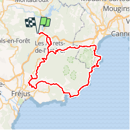
15,4 km | 22 km-effort
5h 22min
![](https://static1.geolcdn.com/siteimages/upload/files/16400158638029165_repeat_loop_refresh_sync_direction_icon.png)
Oui
![Randonnée Marche Fréjus - Plan d'Estérel - Mont Vinaigre - Photo](https://media.geolcdn.com/t/375/260/ext.jpg?maxdim=2&url=https%3A%2F%2Fservices.sitytrail.com%2FGeolivesWS%2FDownloadMedia.ashx%3FTrailID%3D105012%26Media%3D8573_2.jpg)
![Marche Marche](https://static1.geolcdn.com/sitytour/trail-icons/101.png)
Plan d'Estérel - Mont Vinaigre
Marche
Moyen
(1)
Fréjus,
Provence-Alpes-Côte d'Azur,
Var,
France
![](/images/other/stat-length.png)
15,6 km | 22 km-effort
4h 0min
![](https://static1.geolcdn.com/siteimages/upload/files/16400158638029165_repeat_loop_refresh_sync_direction_icon.png)
Oui
![Randonnée Marche Montauroux - CP FONDURANE - Photo](https://media.geolcdn.com/t/375/260/ext.jpg?maxdim=2&url=https%3A%2F%2Fstatic1.geolcdn.com%2Fsiteimages%2Fupload%2Ffiles%2F1553511878bg_sport_marche.png)
![Marche Marche](https://static1.geolcdn.com/sitytour/trail-icons/101.png)
CP FONDURANE
Marche
Facile
(1)
Montauroux,
Provence-Alpes-Côte d'Azur,
Var,
France
![](/images/other/stat-length.png)
7,9 km | 9,5 km-effort
1h 58min
![](https://static1.geolcdn.com/siteimages/upload/files/16400158638029165_repeat_loop_refresh_sync_direction_icon.png)
Oui
![Randonnée Marche Montauroux - Frankrijk - Lac de St. Cassien - Provence - Photo](https://media.geolcdn.com/t/375/260/ext.jpg?maxdim=2&url=https%3A%2F%2Fstatic1.geolcdn.com%2Fsiteimages%2Fupload%2Ffiles%2F1553511878bg_sport_marche.png)
![Marche Marche](https://static1.geolcdn.com/sitytour/trail-icons/101.png)
Frankrijk - Lac de St. Cassien - Provence
Marche
Très facile
(1)
Montauroux,
Provence-Alpes-Côte d'Azur,
Var,
France
![](/images/other/stat-length.png)
13,5 km | 18,7 km-effort
Inconnu
![](https://static1.geolcdn.com/siteimages/upload/files/16400158638029165_repeat_loop_refresh_sync_direction_icon.png)
Non
![Randonnée V.T.T. Tanneron - autour de tanneron - Photo](https://media.geolcdn.com/t/375/260/ext.jpg?maxdim=2&url=https%3A%2F%2Fstatic1.geolcdn.com%2Fsiteimages%2Fupload%2Ffiles%2F1524743154velo.jpg)
![V.T.T. V.T.T.](https://static1.geolcdn.com/sitytour/trail-icons/202.png)
autour de tanneron
V.T.T.
Très difficile
(1)
Tanneron,
Provence-Alpes-Côte d'Azur,
Var,
France
![](/images/other/stat-length.png)
30 km | 41 km-effort
2h 50min
![](https://static1.geolcdn.com/siteimages/upload/files/16400158638029165_repeat_loop_refresh_sync_direction_icon.png)
Oui
![Randonnée Marche Montauroux - Le lac de Saint Cassien et la réserve biologique de Fondurane - Photo](https://media.geolcdn.com/t/375/260/624cf528-9da6-482e-b332-cea4bc123d23.jpg&format=jpg&maxdim=2)
![Marche Marche](https://static1.geolcdn.com/sitytour/trail-icons/101.png)
Le lac de Saint Cassien et la réserve biologique de Fondurane
Marche
Moyen
Montauroux,
Provence-Alpes-Côte d'Azur,
Var,
France
![](/images/other/stat-length.png)
13,7 km | 18 km-effort
4h 51min
![](https://static1.geolcdn.com/siteimages/upload/files/16400158638029165_repeat_loop_refresh_sync_direction_icon.png)
Oui
![Randonnée V.T.T. Les Adrets-de-l'Estérel - Esterel 4 : Fait 06/04/23 TB des Adrets vers le pic de l'ours - Photo](https://media.geolcdn.com/t/375/260/5ffa7b30-2090-4a79-a62c-284b43d64979.jpg&format=jpg&maxdim=2)
![V.T.T. V.T.T.](https://static1.geolcdn.com/sitytour/trail-icons/202.png)
Esterel 4 : Fait 06/04/23 TB des Adrets vers le pic de l'ours
V.T.T.
Moyen
Les Adrets-de-l'Estérel,
Provence-Alpes-Côte d'Azur,
Var,
France
![](/images/other/stat-length.png)
47 km | 64 km-effort
5h 43min
![](https://static1.geolcdn.com/siteimages/upload/files/16400158638029165_repeat_loop_refresh_sync_direction_icon.png)
Oui
![Randonnée V.T.T. Les Adrets-de-l'Estérel - Esterel 6 : Fait 01/04/23 TB tour de l'Esterel par singles et DFCI - Photo](https://media.geolcdn.com/t/375/260/9081b5ac-4e02-4bc7-a13e-72c8be741959.jpg&format=jpg&maxdim=2)
![V.T.T. V.T.T.](https://static1.geolcdn.com/sitytour/trail-icons/202.png)
Esterel 6 : Fait 01/04/23 TB tour de l'Esterel par singles et DFCI
V.T.T.
Difficile
Les Adrets-de-l'Estérel,
Provence-Alpes-Côte d'Azur,
Var,
France
![](/images/other/stat-length.png)
52 km | 69 km-effort
6h 57min
![](https://static1.geolcdn.com/siteimages/upload/files/16400158638029165_repeat_loop_refresh_sync_direction_icon.png)
Oui
![Randonnée Marche Fréjus - z la gardiette 03-01-23 - Photo](https://media.geolcdn.com/t/375/260/32a3c98f-262d-48a3-9c0b-77d00bf599a5.jpg&format=jpg&maxdim=2)
![Marche Marche](https://static1.geolcdn.com/sitytour/trail-icons/101.png)
z la gardiette 03-01-23
Marche
Moyen
Fréjus,
Provence-Alpes-Côte d'Azur,
Var,
France
![](/images/other/stat-length.png)
7,3 km | 9 km-effort
2h 26min
![](https://static1.geolcdn.com/siteimages/upload/files/16400158638029165_repeat_loop_refresh_sync_direction_icon.png)
Oui