![](/images/other/stat-length.png)
![Randonnée Marche La Possession - cirque de Mafate 1 - Photo](https://media.geolcdn.com/t/1900/400/ext.pjpeg?maxdim=2&url=https%3A%2F%2Fstatic1.geolcdn.com%2Fsiteimages%2Fupload%2Ffiles%2F1553511878bg_sport_marche.png)
cirque de Mafate 1
olivier732
Utilisateur
![Longueur](/images/other/stat-length.png)
Longueur
9 km
![Altitude max](https://static1.geolcdn.com/siteimages/upload/files/1508320355ic_sort_altitude_max_24dp.png)
Altitude max
855 m
![Dénivelé positif](https://static1.geolcdn.com/siteimages/upload/files/1508320355ic_sort_den_pos_24dp.png)
Dénivelé positif
881 m
![Km-Effort](/images/other/stat-length.png)
Km-Effort
18,8 km
![Altitude min](https://static1.geolcdn.com/siteimages/upload/files/1508320355ic_sort_altitude_min_24dp.png)
Altitude min
259 m
![Dénivelé négatif](https://static1.geolcdn.com/siteimages/upload/files/1508320355ic_sort_den_neg_24dp.png)
Dénivelé négatif
308 m
![Boucle](https://static1.geolcdn.com/siteimages/upload/files/16400158638029165_repeat_loop_refresh_sync_direction_icon.png)
Boucle
Non
Date de création :
2017-08-13 00:00:00.0
Dernière modification :
2017-08-13 00:00:00.0
![Marche](https://static1.geolcdn.com/sitytour/trail-icons/101.png)
4h09
Difficulté : Difficile
![Scannez ce code QR pour ouvrir la randonnée dans l'application SityTrail](https://capi.geolives.com/qq0zvz2zws4bq2lad0pu/sitytour/trails/801758/qr.png?size=200)
Application GPS de randonnée GRATUITE
À propos
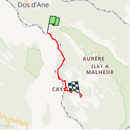
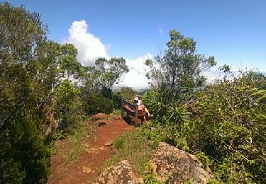
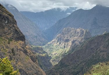
Randonnée Marche de 9 km à découvrir à La Réunion, Inconnu, La Possession. Cette randonnée est proposée par olivier732.
Description
rivière des galets en 4X4 de Le Port à Deux Bras.
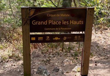
Fenêtres, Tunnel, longer la rivière puis suivi du GR R2, Cayenne (déjeuner) et remontée vers Grand Place puis Grand Place les Hauts en passant par sentier de découverte.
nuit et dîner au gite Éloïse
Localisation
Pays :
France
Région :
La Réunion
Département/Province :
Inconnu
Commune :
La Possession
Localité :
Unknown
Départ:(Dec)
Départ:(UTM)
332970 ; 7676644 (40K) S.
Commentaires
Randonnées à proximité
![Randonnée Marche La Possession - Mafate par Dos d'Ane - Aurere - Cayenne - Dos d'Ane - Photo](https://media.geolcdn.com/t/375/260/ext.jpg?maxdim=2&url=https%3A%2F%2Fstatic1.geolcdn.com%2Fsiteimages%2Fupload%2Ffiles%2F1553511878bg_sport_marche.png)
![Marche Marche](https://static1.geolcdn.com/sitytour/trail-icons/101.png)
Mafate par Dos d'Ane - Aurere - Cayenne - Dos d'Ane
Marche
Difficile
(2)
La Possession,
La Réunion,
Inconnu,
France
![](/images/other/stat-length.png)
30 km | 68 km-effort
9h 0min
![](https://static1.geolcdn.com/siteimages/upload/files/16400158638029165_repeat_loop_refresh_sync_direction_icon.png)
Oui
![Randonnée Marche La Possession - 2023 11 Réalisée - Photo](https://media.geolcdn.com/t/375/260/05dfd58c-18ed-415c-b21e-7ce5c9e44bf9.jpg&format=jpg&maxdim=2)
![Marche Marche](https://static1.geolcdn.com/sitytour/trail-icons/101.png)
2023 11 Réalisée
Marche
Très difficile
La Possession,
La Réunion,
Inconnu,
France
![](/images/other/stat-length.png)
14 km | 29 km-effort
8h 8min
![](https://static1.geolcdn.com/siteimages/upload/files/16400158638029165_repeat_loop_refresh_sync_direction_icon.png)
Non
![Randonnée Marche Saint-Paul - Canalisation des Orangers - Photo](https://media.geolcdn.com/t/375/260/33548ff9-c104-4aa6-a95a-48c5b3d6dd35.jpg&format=jpg&maxdim=2)
![Marche Marche](https://static1.geolcdn.com/sitytour/trail-icons/101.png)
Canalisation des Orangers
Marche
Moyen
Saint-Paul,
La Réunion,
Inconnu,
France
![](/images/other/stat-length.png)
16 km | 35 km-effort
4h 30min
![](https://static1.geolcdn.com/siteimages/upload/files/16400158638029165_repeat_loop_refresh_sync_direction_icon.png)
Non
![Randonnée Marche La Possession - Piton fougère - Photo](https://media.geolcdn.com/t/375/260/b48da831-611a-42d8-9e39-3e75692217b7.jpg&format=jpg&maxdim=2)
![Marche Marche](https://static1.geolcdn.com/sitytour/trail-icons/101.png)
Piton fougère
Marche
Moyen
La Possession,
La Réunion,
Inconnu,
France
![](/images/other/stat-length.png)
9,7 km | 21 km-effort
3h 2min
![](https://static1.geolcdn.com/siteimages/upload/files/16400158638029165_repeat_loop_refresh_sync_direction_icon.png)
Oui
![Randonnée Marche La Possession - grand place la nouvelle - Photo](https://media.geolcdn.com/t/375/260/04480c93-eabe-4d3e-95a1-2ed8fc91883e.jpg&format=jpg&maxdim=2)
![Marche Marche](https://static1.geolcdn.com/sitytour/trail-icons/101.png)
grand place la nouvelle
Marche
Très difficile
La Possession,
La Réunion,
Inconnu,
France
![](/images/other/stat-length.png)
27 km | 72 km-effort
9h 48min
![](https://static1.geolcdn.com/siteimages/upload/files/16400158638029165_repeat_loop_refresh_sync_direction_icon.png)
Non
![Randonnée Marche La Possession - Vert bouteille - Photo](https://media.geolcdn.com/t/375/260/ext.jpg?maxdim=2&url=https%3A%2F%2Fstatic1.geolcdn.com%2Fsiteimages%2Fupload%2Ffiles%2F1553511878bg_sport_marche.png)
![Marche Marche](https://static1.geolcdn.com/sitytour/trail-icons/101.png)
Vert bouteille
Marche
Très facile
(1)
La Possession,
La Réunion,
Inconnu,
France
![](/images/other/stat-length.png)
4 km | 9,6 km-effort
3h 0min
![](https://static1.geolcdn.com/siteimages/upload/files/16400158638029165_repeat_loop_refresh_sync_direction_icon.png)
Oui
![Randonnée Marche La Possession - vert bouteille - Photo](https://media.geolcdn.com/t/375/260/ext.jpg?maxdim=2&url=https%3A%2F%2Fservices.sitytrail.com%2FGeolivesWS%2FDownloadMedia.ashx%3FTrailID%3D176800%26Media%3D20130225120229.jpeg)
![Marche Marche](https://static1.geolcdn.com/sitytour/trail-icons/101.png)
vert bouteille
Marche
Très difficile
La Possession,
La Réunion,
Inconnu,
France
![](/images/other/stat-length.png)
3,9 km | 9,2 km-effort
2h 2min
![](https://static1.geolcdn.com/siteimages/upload/files/16400158638029165_repeat_loop_refresh_sync_direction_icon.png)
Oui
![Randonnée sport La Possession - (J5)-Grand Place les Hauts - Roche Plate (fait-à nettoyer) - Photo](https://media.geolcdn.com/t/375/260/535728e0-91d3-41a5-bb6f-144e87098d26.jpg&format=jpg&maxdim=2)
(J5)-Grand Place les Hauts - Roche Plate (fait-à nettoyer)
sport
Très facile
La Possession,
La Réunion,
Inconnu,
France
![](/images/other/stat-length.png)
12 km | 28 km-effort
Inconnu
![](https://static1.geolcdn.com/siteimages/upload/files/16400158638029165_repeat_loop_refresh_sync_direction_icon.png)
Non
![Randonnée sport La Possession - (J4)-Aurère - Mafate les Hauts (fait) - Photo](https://media.geolcdn.com/t/375/260/0d09f72b-41c2-4c29-9aac-6a60b6d1d150.jpg&format=jpg&maxdim=2)
(J4)-Aurère - Mafate les Hauts (fait)
sport
Très facile
La Possession,
La Réunion,
Inconnu,
France
![](/images/other/stat-length.png)
8,4 km | 16,2 km-effort
Inconnu
![](https://static1.geolcdn.com/siteimages/upload/files/16400158638029165_repeat_loop_refresh_sync_direction_icon.png)
Non