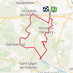
![](/images/other/stat-length.png)
![Randonnée V.T.T. Méré - _Sur les chemins de traverse - Photo](https://media.geolcdn.com/t/1900/400/ext.pjpeg?maxdim=2&url=https%3A%2F%2Fstatic1.geolcdn.com%2Fsiteimages%2Fupload%2Ffiles%2F1524743154velo.jpg)
_Sur les chemins de traverse
Parc naturel régional de la Haute Vallée de Chevreuse
Randonnées du Parc naturel régional de la Haute Vallée de Chevreuse GUIDE+
![Longueur](/images/other/stat-length.png)
![Altitude max](https://static1.geolcdn.com/siteimages/upload/files/1508320355ic_sort_altitude_max_24dp.png)
![Dénivelé positif](https://static1.geolcdn.com/siteimages/upload/files/1508320355ic_sort_den_pos_24dp.png)
![Km-Effort](/images/other/stat-length.png)
![Altitude min](https://static1.geolcdn.com/siteimages/upload/files/1508320355ic_sort_altitude_min_24dp.png)
![Dénivelé négatif](https://static1.geolcdn.com/siteimages/upload/files/1508320355ic_sort_den_neg_24dp.png)
![Boucle](https://static1.geolcdn.com/siteimages/upload/files/16400158638029165_repeat_loop_refresh_sync_direction_icon.png)
![V.T.T.](https://static1.geolcdn.com/sitytour/trail-icons/202.png)
2h15
Difficulté : Moyen
![Scannez ce code QR pour ouvrir la randonnée dans l'application SityTrail](https://capi.geolives.com/qq0zvz2zws4bq2lad0pu/sitytour/trails/801102/qr.png?size=200)
Application GPS de randonnée GRATUITE
À propos
Randonnée V.T.T. de 30 km à découvrir à Île-de-France, Yvelines, Méré. Cette randonnée est proposée par Parc naturel régional de la Haute Vallée de Chevreuse.
Description
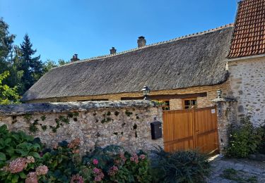
Empruntez les chemins de traverse du pays de Montfort jalonnés
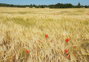
d'anciennes demeures, de maisons d'écrivains et d'artistes... Environné
de paysages bucoliques, vous découvrirez des lieux secrets (ou presque)
qui vous enchanteront.
Localisation
Commentaires
Randonnées à proximité
![Randonnée Marche Bazoches-sur-Guyonne - _Les chaumières de Bazoches - Photo](https://media.geolcdn.com/t/375/260/ext.jpg?maxdim=2&url=https%3A%2F%2Fservices.sitytrail.com%2FGeolivesWS%2FDownloadMedia.ashx%3FTrailID%3D784205%26Media%3D50afe0be-7e96-47da-a0b5-41d8dcd474a4.JPG)
![Marche Marche](https://static1.geolcdn.com/sitytour/trail-icons/101.png)
Marche
![](/images/other/stat-length.png)
![](https://static1.geolcdn.com/siteimages/upload/files/16400158638029165_repeat_loop_refresh_sync_direction_icon.png)
![Randonnée Marche Le Tremblay-sur-Mauldre - rando du 12/03/2015 - Photo](https://media.geolcdn.com/t/375/260/ext.jpg?maxdim=2&url=https%3A%2F%2Fservices.sitytrail.com%2FGeolivesWS%2FDownloadMedia.ashx%3FTrailID%3D394961%26Media%3Dfix__20150312095010.jpg)
![Marche Marche](https://static1.geolcdn.com/sitytour/trail-icons/101.png)
Marche
![](/images/other/stat-length.png)
![](https://static1.geolcdn.com/siteimages/upload/files/16400158638029165_repeat_loop_refresh_sync_direction_icon.png)
![Randonnée Marche Auteuil - Auteuil Villiers le Mahieu - Photo](https://media.geolcdn.com/t/375/260/ext.jpg?maxdim=2&url=https%3A%2F%2Fstatic1.geolcdn.com%2Fsiteimages%2Fupload%2Ffiles%2F1553511878bg_sport_marche.png)
![Marche Marche](https://static1.geolcdn.com/sitytour/trail-icons/101.png)
Marche
![](/images/other/stat-length.png)
![](https://static1.geolcdn.com/siteimages/upload/files/16400158638029165_repeat_loop_refresh_sync_direction_icon.png)
![Randonnée Marche Montfort-l'Amaury - Yvelines_[Rando_Journée]_Montfort=>Les Mesnuls=>Autour_de_Montfort - Tronçon 1 - Photo](https://media.geolcdn.com/t/375/260/9a77b4d0-afa4-42cb-beea-4a17fa8cb8c3.jpg&format=jpg&maxdim=2)
![Marche Marche](https://static1.geolcdn.com/sitytour/trail-icons/101.png)
Marche
![](/images/other/stat-length.png)
![](https://static1.geolcdn.com/siteimages/upload/files/16400158638029165_repeat_loop_refresh_sync_direction_icon.png)
![Randonnée Marche Montfort-l'Amaury - Yvelines_[Rando_Journée]_Montfort=>Les Mesnuls=>Autour_de_Montfort - Tronçon 2 - Photo](https://media.geolcdn.com/t/375/260/3a031c20-1fc4-4232-b97e-93470db48f02.jpg&format=jpg&maxdim=2)
![Marche Marche](https://static1.geolcdn.com/sitytour/trail-icons/101.png)
Marche
![](/images/other/stat-length.png)
![](https://static1.geolcdn.com/siteimages/upload/files/16400158638029165_repeat_loop_refresh_sync_direction_icon.png)
![Randonnée Marche Montfort-l'Amaury - Yvelines_[Rando_Journée]_Montfort=>Les Mesnuls=>Autour_de_Montfort - Photo](https://media.geolcdn.com/t/375/260/87104e12-16e9-47e9-9422-03ff8e98753c.jpg&format=jpg&maxdim=2)
![Marche Marche](https://static1.geolcdn.com/sitytour/trail-icons/101.png)
Marche
![](/images/other/stat-length.png)
![](https://static1.geolcdn.com/siteimages/upload/files/16400158638029165_repeat_loop_refresh_sync_direction_icon.png)
![Randonnée Marche Bazoches-sur-Guyonne - Bazoches - Photo](https://media.geolcdn.com/t/375/260/87864db8-2755-4cea-9ed1-b64f1c4148b4.jpg&format=jpg&maxdim=2)
![Marche Marche](https://static1.geolcdn.com/sitytour/trail-icons/101.png)
Marche
![](/images/other/stat-length.png)
![](https://static1.geolcdn.com/siteimages/upload/files/16400158638029165_repeat_loop_refresh_sync_direction_icon.png)
![Randonnée Avion Neauphle-le-Vieux - Chavenay Etretat - Photo](https://media.geolcdn.com/t/375/260/65d156d0-9e35-4d1c-b0c6-dae3b8d81c13.jpg&format=jpg&maxdim=2)
![Avion Avion](https://static1.geolcdn.com/sitytour/trail-icons/601.png)
Avion
![](/images/other/stat-length.png)
![](https://static1.geolcdn.com/siteimages/upload/files/16400158638029165_repeat_loop_refresh_sync_direction_icon.png)
![Randonnée Marche Méré - Méré Montfort l'Amaury-St. Léger en Yvelines - Photo](https://media.geolcdn.com/t/375/260/478ea850-a94f-4955-bea2-88d9ef4601c2.jpg&format=jpg&maxdim=2)
![Marche Marche](https://static1.geolcdn.com/sitytour/trail-icons/101.png)
Marche
![](/images/other/stat-length.png)
![](https://static1.geolcdn.com/siteimages/upload/files/16400158638029165_repeat_loop_refresh_sync_direction_icon.png)