![](/images/other/stat-length.png)
![Randonnée Marche Séglien - Etang de pont Samouel - Photo](https://media.geolcdn.com/t/1900/400/ext.pjpeg?maxdim=2&url=https%3A%2F%2Fstatic1.geolcdn.com%2Fsiteimages%2Fupload%2Ffiles%2F1553511878bg_sport_marche.png)
Etang de pont Samouel
gildascb
Utilisateur
![Longueur](/images/other/stat-length.png)
Longueur
6,4 km
![Altitude max](https://static1.geolcdn.com/siteimages/upload/files/1508320355ic_sort_altitude_max_24dp.png)
Altitude max
250 m
![Dénivelé positif](https://static1.geolcdn.com/siteimages/upload/files/1508320355ic_sort_den_pos_24dp.png)
Dénivelé positif
93 m
![Km-Effort](/images/other/stat-length.png)
Km-Effort
7,6 km
![Altitude min](https://static1.geolcdn.com/siteimages/upload/files/1508320355ic_sort_altitude_min_24dp.png)
Altitude min
197 m
![Dénivelé négatif](https://static1.geolcdn.com/siteimages/upload/files/1508320355ic_sort_den_neg_24dp.png)
Dénivelé négatif
91 m
![Boucle](https://static1.geolcdn.com/siteimages/upload/files/16400158638029165_repeat_loop_refresh_sync_direction_icon.png)
Boucle
Oui
Date de création :
2017-08-01 00:00:00.0
Dernière modification :
2021-08-12 16:37:01.555
![Marche](https://static1.geolcdn.com/sitytour/trail-icons/101.png)
1h40
Difficulté : Très facile
![Scannez ce code QR pour ouvrir la randonnée dans l'application SityTrail](https://capi.geolives.com/qq0zvz2zws4bq2lad0pu/sitytour/trails/800496/qr.png?size=200)
Application GPS de randonnée GRATUITE
À propos
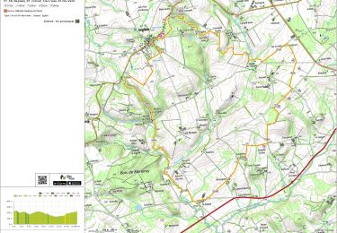
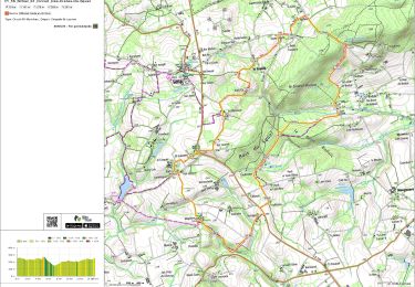
Randonnée Marche de 6,4 km à découvrir à Bretagne, Morbihan, Séglien. Cette randonnée est proposée par gildascb.
Description
Départ de Mangouarec,sur chemin empierré jusqu'à l'étang de Pont Samouel, tour de l'étang, chemin en creux entre 2 champs jusqu'à la chapelle Saint Laurent et retour par la route.
Localisation
Pays :
France
Région :
Bretagne
Département/Province :
Morbihan
Commune :
Séglien
Localité :
Unknown
Départ:(Dec)
Départ:(UTM)
488572 ; 5329908 (30U) N.
Commentaires
Randonnées à proximité
![Randonnée A pied Séglien - Circuit de l'eau et du vent - Photo](https://media.geolcdn.com/t/375/260/ext.jpg?maxdim=2&url=https%3A%2F%2Fmedia.geolcdn.com%2Ff%2Fb68e76dc-ac46-4665-be93-0e9de99a0a6c.jpeg)
![A pied A pied](https://static1.geolcdn.com/sitytour/trail-icons/100.png)
Circuit de l'eau et du vent
A pied
Facile
Séglien,
Bretagne,
Morbihan,
France
![](/images/other/stat-length.png)
7,8 km | 9,3 km-effort
2h 7min
![](https://static1.geolcdn.com/siteimages/upload/files/16400158638029165_repeat_loop_refresh_sync_direction_icon.png)
Non
![Randonnée Marche Séglien - PR_56_Seglien_ZZ_00_Circuit4a_De-L'eau-Et-Du-Vent - Photo](https://media.geolcdn.com/t/375/260/ext.jpg?maxdim=2&url=https%3A%2F%2Fmedia.geolcdn.com%2Ff%2F23184c04-b671-4ef1-ada4-9e893fd99eaa.jpg)
![Marche Marche](https://static1.geolcdn.com/sitytour/trail-icons/101.png)
PR_56_Seglien_ZZ_00_Circuit4a_De-L'eau-Et-Du-Vent
Marche
Facile
Séglien,
Bretagne,
Morbihan,
France
![](/images/other/stat-length.png)
17 km | 20 km-effort
4h 23min
![](https://static1.geolcdn.com/siteimages/upload/files/16400158638029165_repeat_loop_refresh_sync_direction_icon.png)
Oui
![Randonnée Marche Silfiac - PR_56_Silfiac_ZZ_00_Circuit1b_Des-Cretes-Du-Squel - Photo](https://media.geolcdn.com/t/375/260/ext.jpg?maxdim=2&url=https%3A%2F%2Fmedia.geolcdn.com%2Ff%2Fe4235ccb-41e8-4324-9556-1b0b1a137d6f.jpg)
![Marche Marche](https://static1.geolcdn.com/sitytour/trail-icons/101.png)
PR_56_Silfiac_ZZ_00_Circuit1b_Des-Cretes-Du-Squel
Marche
Facile
Silfiac,
Bretagne,
Morbihan,
France
![](/images/other/stat-length.png)
15 km | 18,8 km-effort
4h 0min
![](https://static1.geolcdn.com/siteimages/upload/files/16400158638029165_repeat_loop_refresh_sync_direction_icon.png)
Oui
![Randonnée Marche Silfiac - Silfiac - Circuit des Crêtes du Squel - Photo](https://media.geolcdn.com/t/375/260/ext.jpg?maxdim=2&url=https%3A%2F%2Fstatic1.geolcdn.com%2Fsiteimages%2Fupload%2Ffiles%2F1553511878bg_sport_marche.png)
![Marche Marche](https://static1.geolcdn.com/sitytour/trail-icons/101.png)
Silfiac - Circuit des Crêtes du Squel
Marche
Moyen
Silfiac,
Bretagne,
Morbihan,
France
![](/images/other/stat-length.png)
14,7 km | 18,4 km-effort
4h 0min
![](https://static1.geolcdn.com/siteimages/upload/files/16400158638029165_repeat_loop_refresh_sync_direction_icon.png)
Oui