![](/images/other/stat-length.png)
![Randonnée Marche Willer-sur-Thur - le sommet du thannerhubel - Photo](https://media.geolcdn.com/t/1900/400/ext.pjpeg?maxdim=2&url=https%3A%2F%2Fservices.sitytrail.com%2FGeolivesWS%2FDownloadMedia.ashx%3FTrailID%3D798345%26Media%3Dfix__20170729115716.jpg)
le sommet du thannerhubel
margotte
Utilisateur
![Longueur](/images/other/stat-length.png)
Longueur
13 km
![Altitude max](https://static1.geolcdn.com/siteimages/upload/files/1508320355ic_sort_altitude_max_24dp.png)
Altitude max
1162 m
![Dénivelé positif](https://static1.geolcdn.com/siteimages/upload/files/1508320355ic_sort_den_pos_24dp.png)
Dénivelé positif
756 m
![Km-Effort](/images/other/stat-length.png)
Km-Effort
23 km
![Altitude min](https://static1.geolcdn.com/siteimages/upload/files/1508320355ic_sort_altitude_min_24dp.png)
Altitude min
422 m
![Dénivelé négatif](https://static1.geolcdn.com/siteimages/upload/files/1508320355ic_sort_den_neg_24dp.png)
Dénivelé négatif
773 m
![Boucle](https://static1.geolcdn.com/siteimages/upload/files/16400158638029165_repeat_loop_refresh_sync_direction_icon.png)
Boucle
Oui
Date de création :
2019-06-11 14:16:03.281
Dernière modification :
2020-04-26 15:29:37.989
![Marche](https://static1.geolcdn.com/sitytour/trail-icons/101.png)
5h04
Difficulté : Facile
![Scannez ce code QR pour ouvrir la randonnée dans l'application SityTrail](https://capi.geolives.com/qq0zvz2zws4bq2lad0pu/sitytour/trails/798345/qr.png?size=200)
Application GPS de randonnée GRATUITE
À propos
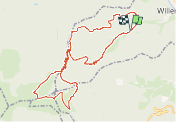
Randonnée Marche de 13 km à découvrir à Grand Est, Haut-Rhin, Willer-sur-Thur. Cette randonnée est proposée par margotte.
Description
montée et descente bien ombragée dans de magnifiques forêts mixtes (érable, Douglas, sapin, hêtre. ..).Chaumes bien ouverte avec une activité pastorale et des fermes auberges où l'on aime s' arrêter.
Localisation
Pays :
France
Région :
Grand Est
Département/Province :
Haut-Rhin
Commune :
Willer-sur-Thur
Localité :
Unknown
Départ:(Dec)
Départ:(UTM)
354266 ; 5300225 (32T) N.
Commentaires
Randonnées à proximité
![Randonnée Marche Bourbach-le-Haut - Tour du Rossberg - Gsang - Thannerhubel - Photo](https://media.geolcdn.com/t/375/260/d4089ace-97e6-4d95-86a3-a999ece263d3.jpg&format=jpg&maxdim=2)
![Marche Marche](https://static1.geolcdn.com/sitytour/trail-icons/101.png)
Tour du Rossberg - Gsang - Thannerhubel
Marche
Difficile
Bourbach-le-Haut,
Grand Est,
Haut-Rhin,
France
![](/images/other/stat-length.png)
11,4 km | 18,5 km-effort
4h 12min
![](https://static1.geolcdn.com/siteimages/upload/files/16400158638029165_repeat_loop_refresh_sync_direction_icon.png)
Oui
![Randonnée Marche Thann - JD 14/20 Thann-roche--albert--grumbachkopf - Photo](https://media.geolcdn.com/t/375/260/ext.jpg?maxdim=2&url=https%3A%2F%2Fstatic1.geolcdn.com%2Fsiteimages%2Fupload%2Ffiles%2F1553511878bg_sport_marche.png)
![Marche Marche](https://static1.geolcdn.com/sitytour/trail-icons/101.png)
JD 14/20 Thann-roche--albert--grumbachkopf
Marche
Moyen
(1)
Thann,
Grand Est,
Haut-Rhin,
France
![](/images/other/stat-length.png)
7,6 km | 12 km-effort
2h 28min
![](https://static1.geolcdn.com/siteimages/upload/files/16400158638029165_repeat_loop_refresh_sync_direction_icon.png)
Oui
![Randonnée A pied Bitschwiller-lès-Thann - Bitschwiller les Thann - Rehbrunnel - Abri du Becherkopf - Roche Albert - Photo](https://media.geolcdn.com/t/375/260/ext.jpg?maxdim=2&url=https%3A%2F%2Fstatic1.geolcdn.com%2Fsiteimages%2Fupload%2Ffiles%2F1545311037marcheuse_200dpi.jpg)
![A pied A pied](https://static1.geolcdn.com/sitytour/trail-icons/100.png)
Bitschwiller les Thann - Rehbrunnel - Abri du Becherkopf - Roche Albert
A pied
Moyen
(1)
Bitschwiller-lès-Thann,
Grand Est,
Haut-Rhin,
France
![](/images/other/stat-length.png)
10,3 km | 16,4 km-effort
Inconnu
![](https://static1.geolcdn.com/siteimages/upload/files/16400158638029165_repeat_loop_refresh_sync_direction_icon.png)
Oui
![Randonnée Marche Bitschwiller-lès-Thann - 68 Col du Hundsrück - FA Gsang - retour ThannerHubel - Photo](https://media.geolcdn.com/t/375/260/ext.jpg?maxdim=2&url=https%3A%2F%2Fstatic1.geolcdn.com%2Fsiteimages%2Fupload%2Ffiles%2F1553511878bg_sport_marche.png)
![Marche Marche](https://static1.geolcdn.com/sitytour/trail-icons/101.png)
68 Col du Hundsrück - FA Gsang - retour ThannerHubel
Marche
Moyen
(1)
Bitschwiller-lès-Thann,
Grand Est,
Haut-Rhin,
France
![](/images/other/stat-length.png)
11,2 km | 18,4 km-effort
3h 48min
![](https://static1.geolcdn.com/siteimages/upload/files/16400158638029165_repeat_loop_refresh_sync_direction_icon.png)
Oui
![Randonnée Marche Thann - Entre Thann et le Molkenrain - Photo](https://media.geolcdn.com/t/375/260/288febbb-1400-419f-925a-b31a67c6a7df.jpg&format=jpg&maxdim=2)
![Marche Marche](https://static1.geolcdn.com/sitytour/trail-icons/101.png)
Entre Thann et le Molkenrain
Marche
Difficile
Thann,
Grand Est,
Haut-Rhin,
France
![](/images/other/stat-length.png)
24 km | 39 km-effort
8h 47min
![](https://static1.geolcdn.com/siteimages/upload/files/16400158638029165_repeat_loop_refresh_sync_direction_icon.png)
Oui
![Randonnée Vélo électrique Thann - Thann lac de Kruth - Photo](https://media.geolcdn.com/t/375/260/f55f8e20-2cc2-42d2-8acb-2cc22e065b5e.jpg&format=jpg&maxdim=2)
![Vélo électrique Vélo électrique](https://static1.geolcdn.com/sitytour/trail-icons/205.png)
Thann lac de Kruth
Vélo électrique
Moyen
Thann,
Grand Est,
Haut-Rhin,
France
![](/images/other/stat-length.png)
49 km | 58 km-effort
4h 2min
![](https://static1.geolcdn.com/siteimages/upload/files/16400158638029165_repeat_loop_refresh_sync_direction_icon.png)
Oui
![Randonnée Marche Saint-Amarin - dimanche - Photo](https://media.geolcdn.com/t/375/260/ext.jpg?maxdim=2&url=https%3A%2F%2Fstatic1.geolcdn.com%2Fsiteimages%2Fupload%2Ffiles%2F1553511878bg_sport_marche.png)
![Marche Marche](https://static1.geolcdn.com/sitytour/trail-icons/101.png)
dimanche
Marche
Très difficile
(1)
Saint-Amarin,
Grand Est,
Haut-Rhin,
France
![](/images/other/stat-length.png)
19,4 km | 35 km-effort
7h 51min
![](https://static1.geolcdn.com/siteimages/upload/files/16400158638029165_repeat_loop_refresh_sync_direction_icon.png)
Oui
![Randonnée Marche Moosch - Moosch Haag - Photo](https://media.geolcdn.com/t/375/260/ext.jpg?maxdim=2&url=https%3A%2F%2Fstatic1.geolcdn.com%2Fsiteimages%2Fupload%2Ffiles%2F1553511878bg_sport_marche.png)
![Marche Marche](https://static1.geolcdn.com/sitytour/trail-icons/101.png)
Moosch Haag
Marche
Difficile
(1)
Moosch,
Grand Est,
Haut-Rhin,
France
![](/images/other/stat-length.png)
21 km | 0 m-effort
5h 27min
![](https://static1.geolcdn.com/siteimages/upload/files/16400158638029165_repeat_loop_refresh_sync_direction_icon.png)
Oui
![Randonnée V.T.C. Moosch - Lac de Kurt et jardin des merveilles - Photo](https://media.geolcdn.com/t/375/260/557dc13c-c583-4fd0-920e-be1089fb90c2.jpg&format=jpg&maxdim=2)
![V.T.C. V.T.C.](https://static1.geolcdn.com/sitytour/trail-icons/203.png)
Lac de Kurt et jardin des merveilles
V.T.C.
Facile
Moosch,
Grand Est,
Haut-Rhin,
France
![](/images/other/stat-length.png)
38 km | 45 km-effort
2h 24min
![](https://static1.geolcdn.com/siteimages/upload/files/16400158638029165_repeat_loop_refresh_sync_direction_icon.png)
Oui