![](/images/other/stat-length.png)
![Randonnée V.T.T. Pérols-sur-Vézère - Perols parcours 5 - Photo](https://media.geolcdn.com/t/1900/400/ext.pjpeg?maxdim=2&url=https%3A%2F%2Fstatic1.geolcdn.com%2Fsiteimages%2Fupload%2Ffiles%2F1524743154velo.jpg)
Perols parcours 5
jm.lemore
Utilisateur
![Longueur](/images/other/stat-length.png)
Longueur
26 km
![Altitude max](https://static1.geolcdn.com/siteimages/upload/files/1508320355ic_sort_altitude_max_24dp.png)
Altitude max
876 m
![Dénivelé positif](https://static1.geolcdn.com/siteimages/upload/files/1508320355ic_sort_den_pos_24dp.png)
Dénivelé positif
566 m
![Km-Effort](/images/other/stat-length.png)
Km-Effort
34 km
![Altitude min](https://static1.geolcdn.com/siteimages/upload/files/1508320355ic_sort_altitude_min_24dp.png)
Altitude min
678 m
![Dénivelé négatif](https://static1.geolcdn.com/siteimages/upload/files/1508320355ic_sort_den_neg_24dp.png)
Dénivelé négatif
567 m
![Boucle](https://static1.geolcdn.com/siteimages/upload/files/16400158638029165_repeat_loop_refresh_sync_direction_icon.png)
Boucle
Oui
Date de création :
2017-08-04 00:00:00.0
Dernière modification :
2017-08-04 00:00:00.0
![V.T.T.](https://static1.geolcdn.com/sitytour/trail-icons/202.png)
3h00
Difficulté : Moyen
![Scannez ce code QR pour ouvrir la randonnée dans l'application SityTrail](https://capi.geolives.com/qq0zvz2zws4bq2lad0pu/sitytour/trails/797723/qr.png?size=200)
Application GPS de randonnée GRATUITE
À propos
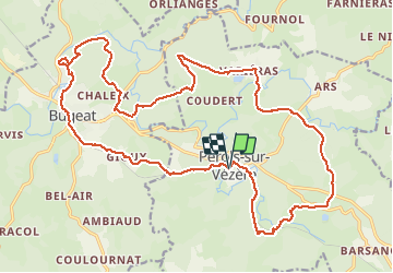
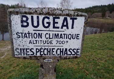
Randonnée V.T.T. de 26 km à découvrir à Nouvelle-Aquitaine, Corrèze, Pérols-sur-Vézère. Cette randonnée est proposée par jm.lemore.
Description
Mon parcours préféré dans le coin.
C'est roulant, joueur, un peu technique, mais jamais longtemps (on peu pousser si on est débutant).
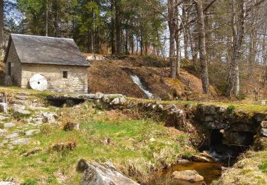
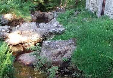
Ne pas rater un arrêt aux moulins de Razel.
Localisation
Pays :
France
Région :
Nouvelle-Aquitaine
Département/Province :
Corrèze
Commune :
Pérols-sur-Vézère
Localité :
Unknown
Départ:(Dec)
Départ:(UTM)
420259 ; 5048507 (31T) N.
Commentaires
Randonnées à proximité
![Randonnée V.T.T. Bugeat - Bugeat N° 34 + 37 - Photo](https://media.geolcdn.com/t/375/260/ext.jpg?maxdim=2&url=https%3A%2F%2Fstatic1.geolcdn.com%2Fsiteimages%2Fupload%2Ffiles%2F1524743154velo.jpg)
![V.T.T. V.T.T.](https://static1.geolcdn.com/sitytour/trail-icons/202.png)
Bugeat N° 34 + 37
V.T.T.
Moyen
(1)
Bugeat,
Nouvelle-Aquitaine,
Corrèze,
France
![](/images/other/stat-length.png)
37 km | 47 km-effort
3h 0min
![](https://static1.geolcdn.com/siteimages/upload/files/16400158638029165_repeat_loop_refresh_sync_direction_icon.png)
Oui
![Randonnée Marche Pérols-sur-Vézère - barsanges - Photo](https://media.geolcdn.com/t/375/260/22a6354d-b2b5-47f2-99b9-76195ea7225f.jpg&format=jpg&maxdim=2)
![Marche Marche](https://static1.geolcdn.com/sitytour/trail-icons/101.png)
barsanges
Marche
Très facile
Pérols-sur-Vézère,
Nouvelle-Aquitaine,
Corrèze,
France
![](/images/other/stat-length.png)
7,6 km | 10,4 km-effort
2h 46min
![](https://static1.geolcdn.com/siteimages/upload/files/16400158638029165_repeat_loop_refresh_sync_direction_icon.png)
Oui
![Randonnée Marche Pérols-sur-Vézère - Varieras_Razel - Photo](https://media.geolcdn.com/t/375/260/75ddd4c0-d750-454a-b4b1-a1ae60b47837.jpg&format=jpg&maxdim=2)
![Marche Marche](https://static1.geolcdn.com/sitytour/trail-icons/101.png)
Varieras_Razel
Marche
Très facile
Pérols-sur-Vézère,
Nouvelle-Aquitaine,
Corrèze,
France
![](/images/other/stat-length.png)
13,8 km | 17,9 km-effort
4h 58min
![](https://static1.geolcdn.com/siteimages/upload/files/16400158638029165_repeat_loop_refresh_sync_direction_icon.png)
Oui
![Randonnée Marche Bugeat - Fred Bugeat la vezere - Photo](https://media.geolcdn.com/t/375/260/fa56c4af-e1c5-4fad-a648-e226c6b7069c.jpg&format=jpg&maxdim=2)
![Marche Marche](https://static1.geolcdn.com/sitytour/trail-icons/101.png)
Fred Bugeat la vezere
Marche
Moyen
Bugeat,
Nouvelle-Aquitaine,
Corrèze,
France
![](/images/other/stat-length.png)
6,5 km | 8 km-effort
3h 21min
![](https://static1.geolcdn.com/siteimages/upload/files/16400158638029165_repeat_loop_refresh_sync_direction_icon.png)
Oui
![Randonnée Marche Pérols-sur-Vézère - perol sur vézére - Photo](https://media.geolcdn.com/t/375/260/82a88b04-692b-4d55-8765-aa20af16bf0c.jpg&format=jpg&maxdim=2)
![Marche Marche](https://static1.geolcdn.com/sitytour/trail-icons/101.png)
perol sur vézére
Marche
Facile
Pérols-sur-Vézère,
Nouvelle-Aquitaine,
Corrèze,
France
![](/images/other/stat-length.png)
10,7 km | 13,7 km-effort
3h 10min
![](https://static1.geolcdn.com/siteimages/upload/files/16400158638029165_repeat_loop_refresh_sync_direction_icon.png)
Oui
![Randonnée Marche Bugeat - balade dans le bois de Chaleix - Photo](https://media.geolcdn.com/t/375/260/ext.jpg?maxdim=2&url=https%3A%2F%2Fservices.sitytrail.com%2FGeolivesWS%2FDownloadMedia.ashx%3FTrailID%3D720212%26Media%3Dfix__20170325170645.jpg)
![Marche Marche](https://static1.geolcdn.com/sitytour/trail-icons/101.png)
balade dans le bois de Chaleix
Marche
Moyen
Bugeat,
Nouvelle-Aquitaine,
Corrèze,
France
![](/images/other/stat-length.png)
6 km | 7,6 km-effort
2h 11min
![](https://static1.geolcdn.com/siteimages/upload/files/16400158638029165_repeat_loop_refresh_sync_direction_icon.png)
Oui
![Randonnée Marche Bugeat - Viam - Photo](https://media.geolcdn.com/t/375/260/ext.jpg?maxdim=2&url=https%3A%2F%2Fstatic1.geolcdn.com%2Fsiteimages%2Fupload%2Ffiles%2F1553511878bg_sport_marche.png)
![Marche Marche](https://static1.geolcdn.com/sitytour/trail-icons/101.png)
Viam
Marche
Très difficile
Bugeat,
Nouvelle-Aquitaine,
Corrèze,
France
![](/images/other/stat-length.png)
17 km | 22 km-effort
1h 6min
![](https://static1.geolcdn.com/siteimages/upload/files/16400158638029165_repeat_loop_refresh_sync_direction_icon.png)
Non
![Randonnée Marche Pérols-sur-Vézère - le site gallo romain des cars (en partie) - Photo](https://media.geolcdn.com/t/375/260/ext.jpg?maxdim=2&url=https%3A%2F%2Fstatic1.geolcdn.com%2Fsiteimages%2Fupload%2Ffiles%2F1553511878bg_sport_marche.png)
![Marche Marche](https://static1.geolcdn.com/sitytour/trail-icons/101.png)
le site gallo romain des cars (en partie)
Marche
Très facile
Pérols-sur-Vézère,
Nouvelle-Aquitaine,
Corrèze,
France
![](/images/other/stat-length.png)
5,8 km | 7,6 km-effort
2h 38min
![](https://static1.geolcdn.com/siteimages/upload/files/16400158638029165_repeat_loop_refresh_sync_direction_icon.png)
Oui
![Randonnée Marche Bugeat - chemin du bois de Chaleix - Photo](https://media.geolcdn.com/t/375/260/ext.jpg?maxdim=2&url=https%3A%2F%2Fstatic1.geolcdn.com%2Fsiteimages%2Fupload%2Ffiles%2F1553511878bg_sport_marche.png)
![Marche Marche](https://static1.geolcdn.com/sitytour/trail-icons/101.png)
chemin du bois de Chaleix
Marche
Facile
Bugeat,
Nouvelle-Aquitaine,
Corrèze,
France
![](/images/other/stat-length.png)
7,1 km | 8,6 km-effort
2h 45min
![](https://static1.geolcdn.com/siteimages/upload/files/16400158638029165_repeat_loop_refresh_sync_direction_icon.png)
Oui