![](/images/other/stat-length.png)
![Randonnée Marche Cervières - le lac des Cordes et le pic du vallon Crouzet - Photo](https://media.geolcdn.com/t/1900/400/ext.pjpeg?maxdim=2&url=https%3A%2F%2Fservices.sitytrail.com%2FGeolivesWS%2FDownloadMedia.ashx%3FTrailID%3D787861%26Media%3Dfix__20170710153913.jpg)
le lac des Cordes et le pic du vallon Crouzet
amiral13
Utilisateur GUIDE
![Longueur](/images/other/stat-length.png)
![Altitude max](https://static1.geolcdn.com/siteimages/upload/files/1508320355ic_sort_altitude_max_24dp.png)
![Dénivelé positif](https://static1.geolcdn.com/siteimages/upload/files/1508320355ic_sort_den_pos_24dp.png)
![Km-Effort](/images/other/stat-length.png)
![Altitude min](https://static1.geolcdn.com/siteimages/upload/files/1508320355ic_sort_altitude_min_24dp.png)
![Dénivelé négatif](https://static1.geolcdn.com/siteimages/upload/files/1508320355ic_sort_den_neg_24dp.png)
![Boucle](https://static1.geolcdn.com/siteimages/upload/files/16400158638029165_repeat_loop_refresh_sync_direction_icon.png)
![Marche](https://static1.geolcdn.com/sitytour/trail-icons/101.png)
4h26
Difficulté : Facile
![Scannez ce code QR pour ouvrir la randonnée dans l'application SityTrail](https://capi.geolives.com/qq0zvz2zws4bq2lad0pu/sitytour/trails/787861/qr.png?size=200)
Application GPS de randonnée GRATUITE
À propos
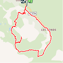
Randonnée Marche de 11,8 km à découvrir à Provence-Alpes-Côte d'Azur, Hautes-Alpes, Cervières. Cette randonnée est proposée par amiral13.
Description
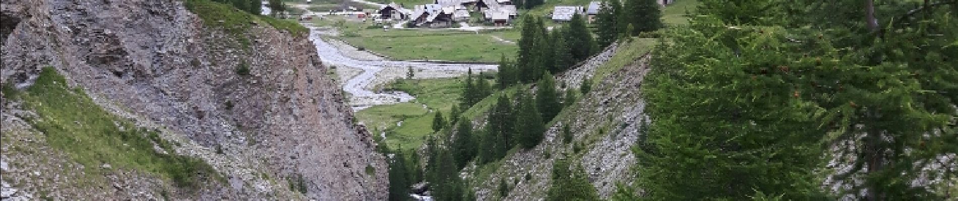
la montée s'effectue en sous-bois jusqu'au passage équipé d'un câble (utile uniquement pour les randonneurs non aguerris).
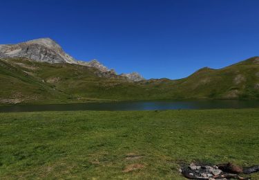
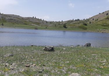
le sentier continu ensuite en alpage jusqu'au lac des cordes.
poursuivre en direction du col des marsailles en passant à proximité du lac des Maits.
du col on partira en direction nord est vers un premier petit mamelon, puis vers un second plus important dont on contournera la crête rocheuses par l'ouest (pour les plus aguerris suivre la crête). revenir au col par le même itinéraire.
Localisation
Commentaires
Randonnées à proximité
![Randonnée Marche Cervières - Le Petit rochebrune par col de péas - Photo](https://media.geolcdn.com/t/375/260/e12553c6-5b67-4a21-b5b9-83e83e9c9741.jpg&format=jpg&maxdim=2)
![Marche Marche](https://static1.geolcdn.com/sitytour/trail-icons/101.png)
Marche
![](/images/other/stat-length.png)
![](https://static1.geolcdn.com/siteimages/upload/files/16400158638029165_repeat_loop_refresh_sync_direction_icon.png)
![Randonnée Marche Cervières - Circuit du Lac des Cordes - Photo](https://media.geolcdn.com/t/375/260/773a9233-b719-442d-b7b1-75196ce74f87.jpg&format=jpg&maxdim=2)
![Marche Marche](https://static1.geolcdn.com/sitytour/trail-icons/101.png)
Marche
![](/images/other/stat-length.png)
![](https://static1.geolcdn.com/siteimages/upload/files/16400158638029165_repeat_loop_refresh_sync_direction_icon.png)
![Randonnée Marche Cervières - Cerviere lac Gignoux - Photo](https://media.geolcdn.com/t/375/260/fb49a4e5-e730-4029-93ed-5953862acf9b.jpg&format=jpg&maxdim=2)
![Marche Marche](https://static1.geolcdn.com/sitytour/trail-icons/101.png)
Marche
![](/images/other/stat-length.png)
![](https://static1.geolcdn.com/siteimages/upload/files/16400158638029165_repeat_loop_refresh_sync_direction_icon.png)
![Randonnée Ski de randonnée Cervières - PT 2944 crête de Dormillouse - Photo](https://media.geolcdn.com/t/375/260/9199c634-7f71-48f6-bcd5-441d1eaab9cb.jpg&format=jpg&maxdim=2)
![Ski de randonnée Ski de randonnée](https://static1.geolcdn.com/sitytour/trail-icons/503.png)
Ski de randonnée
![](/images/other/stat-length.png)
![](https://static1.geolcdn.com/siteimages/upload/files/16400158638029165_repeat_loop_refresh_sync_direction_icon.png)
![Randonnée Marche Cervières - le lasseron col de chaude maison - Photo](https://media.geolcdn.com/t/375/260/a0498023-fd7f-45a6-ba40-c354c806ca60.jpg&format=jpg&maxdim=2)
![Marche Marche](https://static1.geolcdn.com/sitytour/trail-icons/101.png)
Marche
![](/images/other/stat-length.png)
![](https://static1.geolcdn.com/siteimages/upload/files/16400158638029165_repeat_loop_refresh_sync_direction_icon.png)
![Randonnée Marche Cervières - Le Lac des cordes - Photo](https://media.geolcdn.com/t/375/260/4677ed4c-abf4-4114-9dfd-57192ba7a290.jpg&format=jpg&maxdim=2)
![Marche Marche](https://static1.geolcdn.com/sitytour/trail-icons/101.png)
Marche
![](/images/other/stat-length.png)
![](https://static1.geolcdn.com/siteimages/upload/files/16400158638029165_repeat_loop_refresh_sync_direction_icon.png)
![Randonnée Marche Cervières - Le Grand Charvia - Photo](https://media.geolcdn.com/t/375/260/a4ced1e8-abe2-4941-8584-b75521bbb768.jpg&format=jpg&maxdim=2)
![Marche Marche](https://static1.geolcdn.com/sitytour/trail-icons/101.png)
Marche
![](/images/other/stat-length.png)
![](https://static1.geolcdn.com/siteimages/upload/files/16400158638029165_repeat_loop_refresh_sync_direction_icon.png)
![Randonnée Marche Cervières - Cervières - Photo](https://media.geolcdn.com/t/375/260/f561040d-b80f-418b-add3-8cdb93f1c691.jpg&format=jpg&maxdim=2)
![Marche Marche](https://static1.geolcdn.com/sitytour/trail-icons/101.png)
Marche
![](/images/other/stat-length.png)
![](https://static1.geolcdn.com/siteimages/upload/files/16400158638029165_repeat_loop_refresh_sync_direction_icon.png)
![Randonnée Marche Cervières - Arsem Les fonts de Cervieres - Photo](https://media.geolcdn.com/t/375/260/1c663feb-cf6d-4c05-adc4-11e78d8381cd.jpg&format=jpg&maxdim=2)
![Marche Marche](https://static1.geolcdn.com/sitytour/trail-icons/101.png)
Marche
![](/images/other/stat-length.png)
![](https://static1.geolcdn.com/siteimages/upload/files/16400158638029165_repeat_loop_refresh_sync_direction_icon.png)