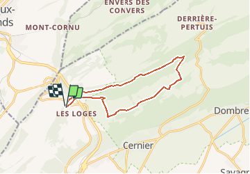
![](/images/other/stat-length.png)
![Randonnée Marche Val-de-Ruz - Circuit col de la vue des Alpes 05.07.17 - Photo](https://media.geolcdn.com/t/1900/400/ext.pjpeg?maxdim=2&url=https%3A%2F%2Fservices.sitytrail.com%2FGeolivesWS%2FDownloadMedia.ashx%3FTrailID%3D784282%26Media%3D39bfaf46-d23e-441b-952e-30f2d30578f2.jpg)
Circuit col de la vue des Alpes 05.07.17
duamerg
Utilisateur
![Longueur](/images/other/stat-length.png)
![Altitude max](https://static1.geolcdn.com/siteimages/upload/files/1508320355ic_sort_altitude_max_24dp.png)
![Dénivelé positif](https://static1.geolcdn.com/siteimages/upload/files/1508320355ic_sort_den_pos_24dp.png)
![Km-Effort](/images/other/stat-length.png)
![Altitude min](https://static1.geolcdn.com/siteimages/upload/files/1508320355ic_sort_altitude_min_24dp.png)
![Dénivelé négatif](https://static1.geolcdn.com/siteimages/upload/files/1508320355ic_sort_den_neg_24dp.png)
![Boucle](https://static1.geolcdn.com/siteimages/upload/files/16400158638029165_repeat_loop_refresh_sync_direction_icon.png)
![Marche](https://static1.geolcdn.com/sitytour/trail-icons/101.png)
3h41
Difficulté : Facile
![Scannez ce code QR pour ouvrir la randonnée dans l'application SityTrail](https://capi.geolives.com/qq0zvz2zws4bq2lad0pu/sitytour/trails/784282/qr.png?size=200)
Application GPS de randonnée GRATUITE
À propos
Randonnée Marche de 11,8 km à découvrir à Neuchâtel, Inconnu, Val-de-Ruz. Cette randonnée est proposée par duamerg.
Description
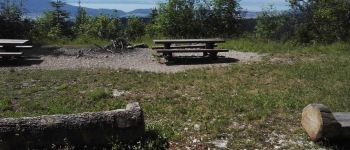
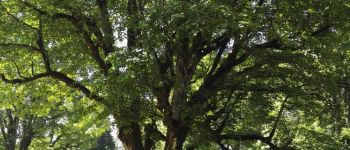
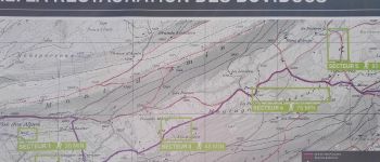
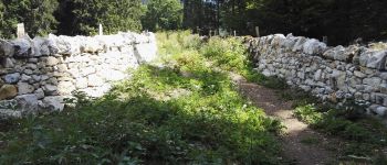
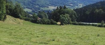
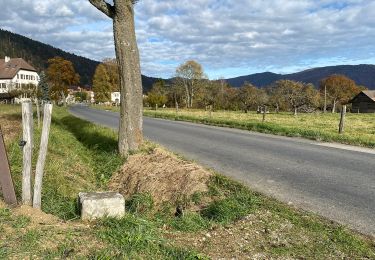
Prendre la direction 'les vieux prés'. Assez rapidement on arrive à une belle place avec tables et vue sur le lac de Neuchâtel. On commence la descente qui prend à travers champs avant de rejoindre quelques belles maisons. De là un superbe chemin ombragé vous mène jusqu'à la restauration de murs en pierre, puis toujours par ce beau chemin on rejoint le hameau de Prés Battereau. Il faut suivre la route avant de trouver des panneaux vous indiquant la Vue des Alpes sur la gauche.
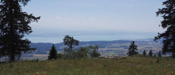
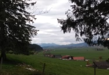
Montez sur le Mont d'Amin à travers la forêt. Une longue traversée à travers champs et forêts vous ramène au point de départ. Une belle vue sur les alpes et le lac vous attend au sommet.
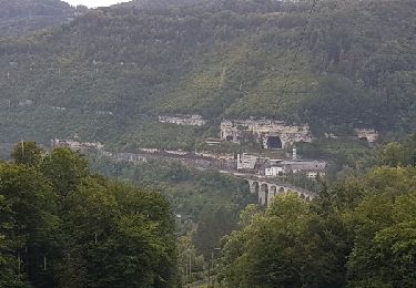
Spécialement intéressant: le très joli chemin de la Montagne de Cernier jusqu'au Pré Battereau. On aimerait en trouver plus souvent des chemins comme celui-ci.
Aucune difficulté pour cette course reposante dans le jura neuchâtelois.
Localisation
Commentaires
Randonnées à proximité
![Randonnée A pied La Chaux-de-Fonds - La Chaux-de-Fonds - Saut du Doubs - Photo](https://media.geolcdn.com/t/375/260/e6429c78-51f2-4265-a7d3-a2fdd44acab9.jpeg&format=jpg&maxdim=2)
![A pied A pied](https://static1.geolcdn.com/sitytour/trail-icons/100.png)
A pied
![](/images/other/stat-length.png)
![](https://static1.geolcdn.com/siteimages/upload/files/16400158638029165_repeat_loop_refresh_sync_direction_icon.png)
![Randonnée A pied Val-de-Ruz - Mont Dar - Vue des Alpes - Photo](https://media.geolcdn.com/t/375/260/e749b2eb-93da-4562-bb4d-f0c0275db1c0.jpeg&format=jpg&maxdim=2)
![A pied A pied](https://static1.geolcdn.com/sitytour/trail-icons/100.png)
A pied
![](/images/other/stat-length.png)
![](https://static1.geolcdn.com/siteimages/upload/files/16400158638029165_repeat_loop_refresh_sync_direction_icon.png)
![Randonnée A pied Val-de-Ruz - Grand Chezard-Villars - Photo](https://media.geolcdn.com/t/375/260/3bf5ff30-7d47-4dfe-9d27-eeef3ea7f5c4.jpeg&format=jpg&maxdim=2)
![A pied A pied](https://static1.geolcdn.com/sitytour/trail-icons/100.png)
A pied
![](/images/other/stat-length.png)
![](https://static1.geolcdn.com/siteimages/upload/files/16400158638029165_repeat_loop_refresh_sync_direction_icon.png)
![Randonnée A pied Val-de-Ruz - Vue des Alpes - La Pouette Mange - Photo](https://media.geolcdn.com/t/375/260/e749b2eb-93da-4562-bb4d-f0c0275db1c0.jpeg&format=jpg&maxdim=2)
![A pied A pied](https://static1.geolcdn.com/sitytour/trail-icons/100.png)
A pied
![](/images/other/stat-length.png)
![](https://static1.geolcdn.com/siteimages/upload/files/16400158638029165_repeat_loop_refresh_sync_direction_icon.png)
![Randonnée A pied Val-de-Ruz - Mont Dar - Le Reymond - Photo](https://media.geolcdn.com/t/375/260/ext.jpg?maxdim=2&url=https%3A%2F%2Fstatic1.geolcdn.com%2Fsiteimages%2Fupload%2Ffiles%2F1545311037marcheuse_200dpi.jpg)
![A pied A pied](https://static1.geolcdn.com/sitytour/trail-icons/100.png)
A pied
![](/images/other/stat-length.png)
![](https://static1.geolcdn.com/siteimages/upload/files/16400158638029165_repeat_loop_refresh_sync_direction_icon.png)
![Randonnée A pied Val-de-Ruz - Mont Dar - fixme - Photo](https://media.geolcdn.com/t/375/260/ext.jpg?maxdim=2&url=https%3A%2F%2Fstatic1.geolcdn.com%2Fsiteimages%2Fupload%2Ffiles%2F1545311037marcheuse_200dpi.jpg)
![A pied A pied](https://static1.geolcdn.com/sitytour/trail-icons/100.png)
A pied
![](/images/other/stat-length.png)
![](https://static1.geolcdn.com/siteimages/upload/files/16400158638029165_repeat_loop_refresh_sync_direction_icon.png)
![Randonnée Marche La Sagne - 09-11-19 sentier des statues - Photo](https://media.geolcdn.com/t/375/260/8ec1ec16-900d-4af5-a961-120cad232354.jpg&format=jpg&maxdim=2)
![Marche Marche](https://static1.geolcdn.com/sitytour/trail-icons/101.png)
Marche
![](/images/other/stat-length.png)
![](https://static1.geolcdn.com/siteimages/upload/files/16400158638029165_repeat_loop_refresh_sync_direction_icon.png)
![Randonnée Vélo La Chaux-de-Fonds - La Chaux de Fonds - St. Ursanne (Jura Suisse) - Photo](https://media.geolcdn.com/t/375/260/ext.jpg?maxdim=2&url=https%3A%2F%2Fservices.sitytrail.com%2FGeolivesWS%2FDownloadMedia.ashx%3FTrailID%3D817688%26Media%3Dfix__20170824162433.jpg)
![Vélo Vélo](https://static1.geolcdn.com/sitytour/trail-icons/200.png)
Vélo
![](/images/other/stat-length.png)
![](https://static1.geolcdn.com/siteimages/upload/files/16400158638029165_repeat_loop_refresh_sync_direction_icon.png)
![Randonnée V.T.T. Val-de-Ruz - Bike32911 - Photo](https://media.geolcdn.com/t/375/260/ext.jpg?maxdim=2&url=https%3A%2F%2Fstatic1.geolcdn.com%2Fsiteimages%2Fupload%2Ffiles%2F1524743154velo.jpg)
![V.T.T. V.T.T.](https://static1.geolcdn.com/sitytour/trail-icons/202.png)
V.T.T.
![](/images/other/stat-length.png)
![](https://static1.geolcdn.com/siteimages/upload/files/16400158638029165_repeat_loop_refresh_sync_direction_icon.png)