![](/images/other/stat-length.png)
![Randonnée V.T.T. Longuyon - Longuyon 1 Rando VTT ou Marche Courte 6,2 km - Photo](https://media.geolcdn.com/t/1900/400/ext.pjpeg?maxdim=2&url=https%3A%2F%2Fstatic1.geolcdn.com%2Fsiteimages%2Fupload%2Ffiles%2F1524743154velo.jpg)
Longuyon 1 Rando VTT ou Marche Courte 6,2 km
dom54400
Utilisateur
![Longueur](/images/other/stat-length.png)
Longueur
6,2 km
![Altitude max](https://static1.geolcdn.com/siteimages/upload/files/1508320355ic_sort_altitude_max_24dp.png)
Altitude max
303 m
![Dénivelé positif](https://static1.geolcdn.com/siteimages/upload/files/1508320355ic_sort_den_pos_24dp.png)
Dénivelé positif
121 m
![Km-Effort](/images/other/stat-length.png)
Km-Effort
7,8 km
![Altitude min](https://static1.geolcdn.com/siteimages/upload/files/1508320355ic_sort_altitude_min_24dp.png)
Altitude min
209 m
![Dénivelé négatif](https://static1.geolcdn.com/siteimages/upload/files/1508320355ic_sort_den_neg_24dp.png)
Dénivelé négatif
119 m
![Boucle](https://static1.geolcdn.com/siteimages/upload/files/16400158638029165_repeat_loop_refresh_sync_direction_icon.png)
Boucle
Oui
Date de création :
2017-06-09 00:00:00.0
Dernière modification :
2017-06-09 00:00:00.0
![V.T.T.](https://static1.geolcdn.com/sitytour/trail-icons/202.png)
32m
Difficulté : Moyen
![Scannez ce code QR pour ouvrir la randonnée dans l'application SityTrail](https://capi.geolives.com/qq0zvz2zws4bq2lad0pu/sitytour/trails/769519/qr.png?size=200)
Application GPS de randonnée GRATUITE
À propos
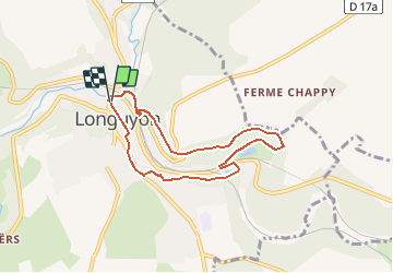
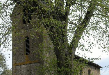
Randonnée V.T.T. de 6,2 km à découvrir à Grand Est, Meurthe-et-Moselle, Longuyon. Cette randonnée est proposée par dom54400.
Description
Randonnée VTT Courte à Longuyon En Lorraine, découverte de la ville et de la nature autour, passage par l'étang de profonde Fontaine et le centre ville, plusieurs pont au dessus de la Crusnes
Localisation
Pays :
France
Région :
Grand Est
Département/Province :
Meurthe-et-Moselle
Commune :
Longuyon
Localité :
Unknown
Départ:(Dec)
Départ:(UTM)
688435 ; 5480499 (31U) N.
Commentaires
Randonnées à proximité
![Randonnée A pied Longuyon - Circuit de Revémont - Photo](https://media.geolcdn.com/t/375/260/f21452ab-062e-4bf2-96f0-8115e60adf9c.jpeg&format=jpg&maxdim=2)
![A pied A pied](https://static1.geolcdn.com/sitytour/trail-icons/100.png)
Circuit de Revémont
A pied
Facile
Longuyon,
Grand Est,
Meurthe-et-Moselle,
France
![](/images/other/stat-length.png)
10,1 km | 12,3 km-effort
2h 48min
![](https://static1.geolcdn.com/siteimages/upload/files/16400158638029165_repeat_loop_refresh_sync_direction_icon.png)
Non
![Randonnée A pied Longuyon - Quatre Fermes - Photo](https://media.geolcdn.com/t/375/260/98ea0501-e137-466e-a7aa-132803d0ec62.jpeg&format=jpg&maxdim=2)
![A pied A pied](https://static1.geolcdn.com/sitytour/trail-icons/100.png)
Quatre Fermes
A pied
Moyen
Longuyon,
Grand Est,
Meurthe-et-Moselle,
France
![](/images/other/stat-length.png)
18,5 km | 23 km-effort
5h 10min
![](https://static1.geolcdn.com/siteimages/upload/files/16400158638029165_repeat_loop_refresh_sync_direction_icon.png)
Oui
![Randonnée A pied Longuyon - Circuilaire du Limaçon - Photo](https://media.geolcdn.com/t/375/260/a5b89b0f-547e-4d5c-a3a5-9ced22e0ee49.jpeg&format=jpg&maxdim=2)
![A pied A pied](https://static1.geolcdn.com/sitytour/trail-icons/100.png)
Circuilaire du Limaçon
A pied
Facile
Longuyon,
Grand Est,
Meurthe-et-Moselle,
France
![](/images/other/stat-length.png)
8,8 km | 11,9 km-effort
2h 42min
![](https://static1.geolcdn.com/siteimages/upload/files/16400158638029165_repeat_loop_refresh_sync_direction_icon.png)
Oui
![Randonnée A pied Grand-Failly - Circuit des Épis d'Or - Photo](https://media.geolcdn.com/t/375/260/fefa0d98-3004-404d-8c64-471b3dc22ff9.jpeg&format=jpg&maxdim=2)
![A pied A pied](https://static1.geolcdn.com/sitytour/trail-icons/100.png)
Circuit des Épis d'Or
A pied
Facile
Grand-Failly,
Grand Est,
Meurthe-et-Moselle,
France
![](/images/other/stat-length.png)
12,4 km | 15,1 km-effort
3h 25min
![](https://static1.geolcdn.com/siteimages/upload/files/16400158638029165_repeat_loop_refresh_sync_direction_icon.png)
Oui
![Randonnée A pied Viviers-sur-Chiers - CV Longuyon Verte - Photo](https://media.geolcdn.com/t/375/260/44260bb7-9052-40d4-a103-929e25068bc2.jpeg&format=jpg&maxdim=2)
![A pied A pied](https://static1.geolcdn.com/sitytour/trail-icons/100.png)
CV Longuyon Verte
A pied
Facile
Viviers-sur-Chiers,
Grand Est,
Meurthe-et-Moselle,
France
![](/images/other/stat-length.png)
3,2 km | 3,7 km-effort
50min
![](https://static1.geolcdn.com/siteimages/upload/files/16400158638029165_repeat_loop_refresh_sync_direction_icon.png)
Non
![Randonnée Marche Villette - Villette 19-05-23 - Photo](https://media.geolcdn.com/t/375/260/bdcbc3e4-4232-4efc-a22d-8c8ed8a923cc.jpg&format=jpg&maxdim=2)
![Marche Marche](https://static1.geolcdn.com/sitytour/trail-icons/101.png)
Villette 19-05-23
Marche
Facile
Villette,
Grand Est,
Meurthe-et-Moselle,
France
![](/images/other/stat-length.png)
3,9 km | 4,4 km-effort
59min
![](https://static1.geolcdn.com/siteimages/upload/files/16400158638029165_repeat_loop_refresh_sync_direction_icon.png)
Oui
![Randonnée A pied Longuyon - moncel 9.01.2024 - Photo](https://media.geolcdn.com/t/375/260/ext.jpg?maxdim=2&url=https%3A%2F%2Fstatic1.geolcdn.com%2Fsiteimages%2Fupload%2Ffiles%2F1545311037marcheuse_200dpi.jpg)
![A pied A pied](https://static1.geolcdn.com/sitytour/trail-icons/100.png)
moncel 9.01.2024
A pied
Facile
Longuyon,
Grand Est,
Meurthe-et-Moselle,
France
![](/images/other/stat-length.png)
6,8 km | 8,3 km-effort
1h 53min
![](https://static1.geolcdn.com/siteimages/upload/files/16400158638029165_repeat_loop_refresh_sync_direction_icon.png)
Oui
![Randonnée A pied Longuyon - beaujolais cv 21.11.2024 - Photo](https://media.geolcdn.com/t/375/260/ext.jpg?maxdim=2&url=https%3A%2F%2Fstatic1.geolcdn.com%2Fsiteimages%2Fupload%2Ffiles%2F1545311037marcheuse_200dpi.jpg)
![A pied A pied](https://static1.geolcdn.com/sitytour/trail-icons/100.png)
beaujolais cv 21.11.2024
A pied
Facile
(1)
Longuyon,
Grand Est,
Meurthe-et-Moselle,
France
![](/images/other/stat-length.png)
5,8 km | 8,1 km-effort
1h 50min
![](https://static1.geolcdn.com/siteimages/upload/files/16400158638029165_repeat_loop_refresh_sync_direction_icon.png)
Oui
![Randonnée A pied Saint-Laurent-sur-Othain - rond fontaine - Photo](https://media.geolcdn.com/t/375/260/ext.jpg?maxdim=2&url=https%3A%2F%2Fstatic1.geolcdn.com%2Fsiteimages%2Fupload%2Ffiles%2F1545311037marcheuse_200dpi.jpg)
![A pied A pied](https://static1.geolcdn.com/sitytour/trail-icons/100.png)
rond fontaine
A pied
Facile
Saint-Laurent-sur-Othain,
Grand Est,
Meuse,
France
![](/images/other/stat-length.png)
8,3 km | 9,9 km-effort
2h 15min
![](https://static1.geolcdn.com/siteimages/upload/files/16400158638029165_repeat_loop_refresh_sync_direction_icon.png)
Oui