![](/images/other/stat-length.png)
![Randonnée Marche Miazzina - Italie, Le Monte Todun - Photo](https://media.geolcdn.com/t/1900/400/ext.pjpeg?maxdim=2&url=https%3A%2F%2Fstatic1.geolcdn.com%2Fsiteimages%2Fupload%2Ffiles%2F1553511878bg_sport_marche.png)
Italie, Le Monte Todun
zanogueb
Utilisateur
![Longueur](/images/other/stat-length.png)
![Altitude max](https://static1.geolcdn.com/siteimages/upload/files/1508320355ic_sort_altitude_max_24dp.png)
![Dénivelé positif](https://static1.geolcdn.com/siteimages/upload/files/1508320355ic_sort_den_pos_24dp.png)
![Km-Effort](/images/other/stat-length.png)
![Altitude min](https://static1.geolcdn.com/siteimages/upload/files/1508320355ic_sort_altitude_min_24dp.png)
![Dénivelé négatif](https://static1.geolcdn.com/siteimages/upload/files/1508320355ic_sort_den_neg_24dp.png)
![Boucle](https://static1.geolcdn.com/siteimages/upload/files/16400158638029165_repeat_loop_refresh_sync_direction_icon.png)
![Marche](https://static1.geolcdn.com/sitytour/trail-icons/101.png)
4h53
Difficulté : Difficile
![Scannez ce code QR pour ouvrir la randonnée dans l'application SityTrail](https://capi.geolives.com/qq0zvz2zws4bq2lad0pu/sitytour/trails/759828/qr.png?size=200)
Application GPS de randonnée GRATUITE
À propos
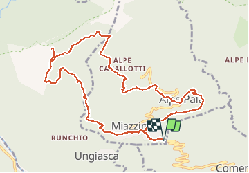
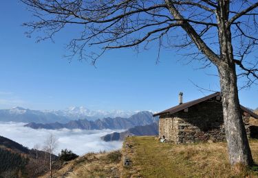
Randonnée Marche de 12,8 km à découvrir à Piémont, Verbano-Cusio-Ossola, Miazzina. Cette randonnée est proposée par zanogueb.
Description
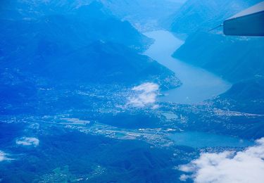
Départ vers Miazzina. La randonnée permet de découvrir la nature sauvage qui annonce l'entrée dans le Parc National de Val Grande que l'on aperçoit du sommet du Monte Todun. Le parcours se poursuit dans l'arrière-pays de Verbania, avec vues sur le Lac Majeur. Balcon sur le très vaste Parc National de 15000 hectares. Puis, retour vers la Chapelle Fina par un bois et arrivée à Miazzina.
Localisation
Commentaires
Randonnées à proximité
![Randonnée A pied Aurano - R15 Aurano - Calpera - il Colle - Photo](https://media.geolcdn.com/t/375/260/b5041733-af99-46d1-b8c6-be72241b576c.jpeg&format=jpg&maxdim=2)
![A pied A pied](https://static1.geolcdn.com/sitytour/trail-icons/100.png)
A pied
![](/images/other/stat-length.png)
![](https://static1.geolcdn.com/siteimages/upload/files/16400158638029165_repeat_loop_refresh_sync_direction_icon.png)
![Randonnée A pied Aurano - R13 Scareno - Pian d'Arla - Photo](https://media.geolcdn.com/t/375/260/19165ffd-ed09-466b-b6a1-8a69b42fad33.jpeg&format=jpg&maxdim=2)
![A pied A pied](https://static1.geolcdn.com/sitytour/trail-icons/100.png)
A pied
![](/images/other/stat-length.png)
![](https://static1.geolcdn.com/siteimages/upload/files/16400158638029165_repeat_loop_refresh_sync_direction_icon.png)
![Randonnée A pied Aurano - R11 Scareno - Alpe Piaggia - Passo Folungo - Photo](https://media.geolcdn.com/t/375/260/e1eed737-bcd5-4dc6-a8b7-7c6c2277c0f8.jpeg&format=jpg&maxdim=2)
![A pied A pied](https://static1.geolcdn.com/sitytour/trail-icons/100.png)
A pied
![](/images/other/stat-length.png)
![](https://static1.geolcdn.com/siteimages/upload/files/16400158638029165_repeat_loop_refresh_sync_direction_icon.png)
![Randonnée A pied Aurano - R08 Aurano - Esio - Premeno - Photo](https://media.geolcdn.com/t/375/260/b5041733-af99-46d1-b8c6-be72241b576c.jpeg&format=jpg&maxdim=2)
![A pied A pied](https://static1.geolcdn.com/sitytour/trail-icons/100.png)
A pied
![](/images/other/stat-length.png)
![](https://static1.geolcdn.com/siteimages/upload/files/16400158638029165_repeat_loop_refresh_sync_direction_icon.png)
![Randonnée A pied Miazzina - R03a Cappella Fina bivio R03 - Bivio R05 tra Cappella Porta e Cornala - Photo](https://media.geolcdn.com/t/375/260/00c4334e-506f-41c9-b8e0-5be565926aad.jpeg&format=jpg&maxdim=2)
![A pied A pied](https://static1.geolcdn.com/sitytour/trail-icons/100.png)
A pied
![](/images/other/stat-length.png)
![](https://static1.geolcdn.com/siteimages/upload/files/16400158638029165_repeat_loop_refresh_sync_direction_icon.png)
![Randonnée A pied Caprezzo - R05 Caprezzo - Pian Cavallone bivio R07 - Photo](https://media.geolcdn.com/t/375/260/00c4334e-506f-41c9-b8e0-5be565926aad.jpeg&format=jpg&maxdim=2)
![A pied A pied](https://static1.geolcdn.com/sitytour/trail-icons/100.png)
A pied
![](/images/other/stat-length.png)
![](https://static1.geolcdn.com/siteimages/upload/files/16400158638029165_repeat_loop_refresh_sync_direction_icon.png)
![Randonnée A pied Intragna - R07 Intragna - Cappella del Pian Cavallone - Photo](https://media.geolcdn.com/t/375/260/00c4334e-506f-41c9-b8e0-5be565926aad.jpeg&format=jpg&maxdim=2)
![A pied A pied](https://static1.geolcdn.com/sitytour/trail-icons/100.png)
A pied
![](/images/other/stat-length.png)
![](https://static1.geolcdn.com/siteimages/upload/files/16400158638029165_repeat_loop_refresh_sync_direction_icon.png)
![Randonnée A pied Cambiasca - R03 Cambiasca - Pian Cavallone - Pizzo Marona - Monte Zeda - Photo](https://media.geolcdn.com/t/375/260/de5ab5de-a475-4e03-a5e9-bac3f3a94f68.jpeg&format=jpg&maxdim=2)
![A pied A pied](https://static1.geolcdn.com/sitytour/trail-icons/100.png)
A pied
![](/images/other/stat-length.png)
![](https://static1.geolcdn.com/siteimages/upload/files/16400158638029165_repeat_loop_refresh_sync_direction_icon.png)
![Randonnée A pied Aurano - R14 Aurano - Luera - Photo](https://media.geolcdn.com/t/375/260/2f93f67d-e4ca-487a-a9d1-ce49628fe8d2.jpeg&format=jpg&maxdim=2)
![A pied A pied](https://static1.geolcdn.com/sitytour/trail-icons/100.png)
A pied
![](/images/other/stat-length.png)
![](https://static1.geolcdn.com/siteimages/upload/files/16400158638029165_repeat_loop_refresh_sync_direction_icon.png)