![](/images/other/stat-length.png)
![Randonnée Marche Meaux - Canal autour de Meaux - Photo](https://media.geolcdn.com/t/1900/400/ext.pjpeg?maxdim=2&url=https%3A%2F%2Fstatic1.geolcdn.com%2Fsiteimages%2Fupload%2Ffiles%2F1553511878bg_sport_marche.png)
Canal autour de Meaux
Emmanuel1971
Utilisateur
![Longueur](/images/other/stat-length.png)
Longueur
11,4 km
![Altitude max](https://static1.geolcdn.com/siteimages/upload/files/1508320355ic_sort_altitude_max_24dp.png)
Altitude max
73 m
![Dénivelé positif](https://static1.geolcdn.com/siteimages/upload/files/1508320355ic_sort_den_pos_24dp.png)
Dénivelé positif
72 m
![Km-Effort](/images/other/stat-length.png)
Km-Effort
12,3 km
![Altitude min](https://static1.geolcdn.com/siteimages/upload/files/1508320355ic_sort_altitude_min_24dp.png)
Altitude min
44 m
![Dénivelé négatif](https://static1.geolcdn.com/siteimages/upload/files/1508320355ic_sort_den_neg_24dp.png)
Dénivelé négatif
72 m
![Boucle](https://static1.geolcdn.com/siteimages/upload/files/16400158638029165_repeat_loop_refresh_sync_direction_icon.png)
Boucle
Oui
Date de création :
2017-05-22 00:00:00.0
Dernière modification :
2017-05-22 00:00:00.0
![Marche](https://static1.geolcdn.com/sitytour/trail-icons/101.png)
2h51
Difficulté : Facile
![Scannez ce code QR pour ouvrir la randonnée dans l'application SityTrail](https://capi.geolives.com/qq0zvz2zws4bq2lad0pu/sitytour/trails/757888/qr.png?size=200)
Application GPS de randonnée GRATUITE
À propos
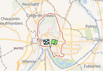
Randonnée Marche de 11,4 km à découvrir à Île-de-France, Seine-et-Marne, Meaux. Cette randonnée est proposée par Emmanuel1971.
Description
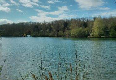
Départ du parking de la salle des fêtes, essentiellement le long du canal, un peu de ville et un passage au parc du Pâtis
Localisation
Pays :
France
Région :
Île-de-France
Département/Province :
Seine-et-Marne
Commune :
Meaux
Localité :
Unknown
Départ:(Dec)
Départ:(UTM)
491645 ; 5422090 (31U) N.
Commentaires
Randonnées à proximité
![Randonnée Marche Crégy-lès-Meaux - SM_CREGY-LES-MEAUX_8Km - Photo](https://media.geolcdn.com/t/375/260/4a1646b8-cb34-4e33-b775-fb442311006b.jpg&format=jpg&maxdim=2)
![Marche Marche](https://static1.geolcdn.com/sitytour/trail-icons/101.png)
SM_CREGY-LES-MEAUX_8Km
Marche
Moyen
(8)
Crégy-lès-Meaux,
Île-de-France,
Seine-et-Marne,
France
![](/images/other/stat-length.png)
7,8 km | 9,2 km-effort
2h 5min
![](https://static1.geolcdn.com/siteimages/upload/files/16400158638029165_repeat_loop_refresh_sync_direction_icon.png)
Oui
![Randonnée V.T.T. Nanteuil-lès-Meaux - tite boucle Nanteuil par l'eau - Photo](https://media.geolcdn.com/t/375/260/ext.jpg?maxdim=2&url=https%3A%2F%2Fservices.sitytrail.com%2FGeolivesWS%2FDownloadMedia.ashx%3FTrailID%3D263705%26Media%3Dfix__20140406122359.jpg)
![V.T.T. V.T.T.](https://static1.geolcdn.com/sitytour/trail-icons/202.png)
tite boucle Nanteuil par l'eau
V.T.T.
Facile
(1)
Nanteuil-lès-Meaux,
Île-de-France,
Seine-et-Marne,
France
![](/images/other/stat-length.png)
23 km | 26 km-effort
1h 48min
![](https://static1.geolcdn.com/siteimages/upload/files/16400158638029165_repeat_loop_refresh_sync_direction_icon.png)
Oui
![Randonnée Marche Meaux - SM_MEAUX_LePâtis_8km. - Photo](https://media.geolcdn.com/t/375/260/59d59af8-64ac-4cd9-8525-6af37371405a.jpg&format=jpg&maxdim=2)
![Marche Marche](https://static1.geolcdn.com/sitytour/trail-icons/101.png)
SM_MEAUX_LePâtis_8km.
Marche
Facile
(3)
Meaux,
Île-de-France,
Seine-et-Marne,
France
![](/images/other/stat-length.png)
7,9 km | 8,4 km-effort
1h 54min
![](https://static1.geolcdn.com/siteimages/upload/files/16400158638029165_repeat_loop_refresh_sync_direction_icon.png)
Oui
![Randonnée Marche Meaux - Le chemin de St Colomban en Ile de France Etape 3 Jouarre Meaux - Photo](https://media.geolcdn.com/t/375/260/17b30d06-8e11-4bee-afb1-3cf425f57ffe.jpg&format=jpg&maxdim=2)
![Marche Marche](https://static1.geolcdn.com/sitytour/trail-icons/101.png)
Le chemin de St Colomban en Ile de France Etape 3 Jouarre Meaux
Marche
Très difficile
Meaux,
Île-de-France,
Seine-et-Marne,
France
![](/images/other/stat-length.png)
36 km | 43 km-effort
9h 41min
![](https://static1.geolcdn.com/siteimages/upload/files/16400158638029165_repeat_loop_refresh_sync_direction_icon.png)
Non
![Randonnée Marche Trilport - GR15-07 Trilport à Changis-sur-Marne - Photo](https://media.geolcdn.com/t/375/260/ext.jpg?maxdim=2&url=https%3A%2F%2Fstatic1.geolcdn.com%2Fsiteimages%2Fupload%2Ffiles%2F1553511878bg_sport_marche.png)
![Marche Marche](https://static1.geolcdn.com/sitytour/trail-icons/101.png)
GR15-07 Trilport à Changis-sur-Marne
Marche
Difficile
(1)
Trilport,
Île-de-France,
Seine-et-Marne,
France
![](/images/other/stat-length.png)
10,6 km | 12,7 km-effort
2h 52min
![](https://static1.geolcdn.com/siteimages/upload/files/16400158638029165_repeat_loop_refresh_sync_direction_icon.png)
Non
![Randonnée Marche Meaux - GR15-06 Meaux à Trilport - Photo](https://media.geolcdn.com/t/375/260/ext.jpg?maxdim=2&url=https%3A%2F%2Fstatic1.geolcdn.com%2Fsiteimages%2Fupload%2Ffiles%2F1553511878bg_sport_marche.png)
![Marche Marche](https://static1.geolcdn.com/sitytour/trail-icons/101.png)
GR15-06 Meaux à Trilport
Marche
Difficile
(1)
Meaux,
Île-de-France,
Seine-et-Marne,
France
![](/images/other/stat-length.png)
15,7 km | 18,6 km-effort
4h 13min
![](https://static1.geolcdn.com/siteimages/upload/files/16400158638029165_repeat_loop_refresh_sync_direction_icon.png)
Non
![Randonnée Marche Meaux - Le tour du Grand Paris via le GR1 - Etape 10 Meaux Mortcerf - Photo](https://media.geolcdn.com/t/375/260/bf5605a3-71d6-489a-a1f1-655ab44fd4d2.jpg&format=jpg&maxdim=2)
![Marche Marche](https://static1.geolcdn.com/sitytour/trail-icons/101.png)
Le tour du Grand Paris via le GR1 - Etape 10 Meaux Mortcerf
Marche
Difficile
Meaux,
Île-de-France,
Seine-et-Marne,
France
![](/images/other/stat-length.png)
34 km | 40 km-effort
6h 35min
![](https://static1.geolcdn.com/siteimages/upload/files/16400158638029165_repeat_loop_refresh_sync_direction_icon.png)
Non
![Randonnée Marche Meaux - MEAUX BOUCLE 19 KM - Photo](https://media.geolcdn.com/t/375/260/ext.jpg?maxdim=2&url=https%3A%2F%2Fstatic1.geolcdn.com%2Fsiteimages%2Fupload%2Ffiles%2F1553511878bg_sport_marche.png)
![Marche Marche](https://static1.geolcdn.com/sitytour/trail-icons/101.png)
MEAUX BOUCLE 19 KM
Marche
Très facile
(1)
Meaux,
Île-de-France,
Seine-et-Marne,
France
![](/images/other/stat-length.png)
19,1 km | 22 km-effort
4h 47min
![](https://static1.geolcdn.com/siteimages/upload/files/16400158638029165_repeat_loop_refresh_sync_direction_icon.png)
Oui
![Randonnée Course à pied Meaux - Meaux Condorcet - Photo](https://media.geolcdn.com/t/375/260/ext.jpg?maxdim=2&url=https%3A%2F%2Fstatic1.geolcdn.com%2Fsiteimages%2Fupload%2Ffiles%2F1524743154running.jpg)
![Course à pied Course à pied](https://static1.geolcdn.com/sitytour/trail-icons/103.png)
Meaux Condorcet
Course à pied
Très facile
(2)
Meaux,
Île-de-France,
Seine-et-Marne,
France
![](/images/other/stat-length.png)
11,5 km | 12,5 km-effort
1h 0min
![](https://static1.geolcdn.com/siteimages/upload/files/16400158638029165_repeat_loop_refresh_sync_direction_icon.png)
Oui
belle randonnée