![](/images/other/stat-length.png)
![Randonnée Marche Collégien - Ferrieres - Photo](https://media.geolcdn.com/t/1900/400/ext.pjpeg?maxdim=2&url=https%3A%2F%2Fstatic1.geolcdn.com%2Fsiteimages%2Fupload%2Ffiles%2F1553511878bg_sport_marche.png)
Ferrieres
Randos du mercredi
Le mercredi c'est rando
![Longueur](/images/other/stat-length.png)
Longueur
8,6 km
![Altitude max](https://static1.geolcdn.com/siteimages/upload/files/1508320355ic_sort_altitude_max_24dp.png)
Altitude max
123 m
![Dénivelé positif](https://static1.geolcdn.com/siteimages/upload/files/1508320355ic_sort_den_pos_24dp.png)
Dénivelé positif
55 m
![Km-Effort](/images/other/stat-length.png)
Km-Effort
9,4 km
![Altitude min](https://static1.geolcdn.com/siteimages/upload/files/1508320355ic_sort_altitude_min_24dp.png)
Altitude min
110 m
![Dénivelé négatif](https://static1.geolcdn.com/siteimages/upload/files/1508320355ic_sort_den_neg_24dp.png)
Dénivelé négatif
55 m
![Boucle](https://static1.geolcdn.com/siteimages/upload/files/16400158638029165_repeat_loop_refresh_sync_direction_icon.png)
Boucle
Oui
Date de création :
2017-05-03 00:00:00.0
Dernière modification :
2022-06-10 09:27:25.594
![Marche](https://static1.geolcdn.com/sitytour/trail-icons/101.png)
2h12
Difficulté : Moyen
![Scannez ce code QR pour ouvrir la randonnée dans l'application SityTrail](https://capi.geolives.com/qq0zvz2zws4bq2lad0pu/sitytour/trails/744970/qr.png?size=200)
Application GPS de randonnée GRATUITE
À propos
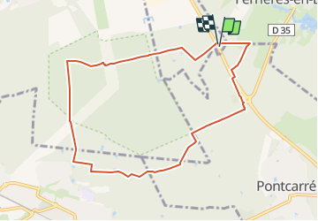
Randonnée Marche de 8,6 km à découvrir à Île-de-France, Seine-et-Marne, Collégien. Cette randonnée est proposée par Randos du mercredi.
Description
balade de demi journée- parking : allée de Piscop & D471 à Ferrieres en Brie
Localisation
Pays :
France
Région :
Île-de-France
Département/Province :
Seine-et-Marne
Commune :
Collégien
Localité :
Unknown
Départ:(Dec)
Départ:(UTM)
477349 ; 5406960 (31U) N.
Commentaires
Randonnées à proximité
![Marche Marche](https://static1.geolcdn.com/sitytour/trail-icons/101.png)
JC 09 Du Parc de Rentilly au Ru de la Gondoire
Marche
Difficile
(1)
Saint-Thibault-des-Vignes,
Île-de-France,
Seine-et-Marne,
France
![](/images/other/stat-length.png)
21 km | 24 km-effort
5h 20min
![](https://static1.geolcdn.com/siteimages/upload/files/16400158638029165_repeat_loop_refresh_sync_direction_icon.png)
Oui
![Randonnée Marche Lognes - EvadRando2024-12km - Photo](https://media.geolcdn.com/t/375/260/ext.jpg?maxdim=2&url=https%3A%2F%2Fstatic1.geolcdn.com%2Fsiteimages%2Fupload%2Ffiles%2F1553511878bg_sport_marche.png)
![Marche Marche](https://static1.geolcdn.com/sitytour/trail-icons/101.png)
EvadRando2024-12km
Marche
Difficile
(2)
Lognes,
Île-de-France,
Seine-et-Marne,
France
![](/images/other/stat-length.png)
12,3 km | 14,1 km-effort
3h 12min
![](https://static1.geolcdn.com/siteimages/upload/files/16400158638029165_repeat_loop_refresh_sync_direction_icon.png)
Oui
![Randonnée Marche Lognes - EvadRando2024-17km - Photo](https://media.geolcdn.com/t/375/260/ext.jpg?maxdim=2&url=https%3A%2F%2Fstatic1.geolcdn.com%2Fsiteimages%2Fupload%2Ffiles%2F1553511878bg_sport_marche.png)
![Marche Marche](https://static1.geolcdn.com/sitytour/trail-icons/101.png)
EvadRando2024-17km
Marche
Difficile
(1)
Lognes,
Île-de-France,
Seine-et-Marne,
France
![](/images/other/stat-length.png)
16,7 km | 18,3 km-effort
4h 9min
![](https://static1.geolcdn.com/siteimages/upload/files/16400158638029165_repeat_loop_refresh_sync_direction_icon.png)
Oui
![Randonnée Marche Bussy-Saint-Georges - Boucle Rentilly - Noisiel - Etang de la Brosse - Etang de la Loy - Photo](https://media.geolcdn.com/t/375/260/2ae0fdb4-e8bd-41dd-b6e1-a0c5cc184bfe.jpg&format=jpg&maxdim=2)
![Marche Marche](https://static1.geolcdn.com/sitytour/trail-icons/101.png)
Boucle Rentilly - Noisiel - Etang de la Brosse - Etang de la Loy
Marche
Très difficile
Bussy-Saint-Georges,
Île-de-France,
Seine-et-Marne,
France
![](/images/other/stat-length.png)
25 km | 29 km-effort
6h 32min
![](https://static1.geolcdn.com/siteimages/upload/files/16400158638029165_repeat_loop_refresh_sync_direction_icon.png)
Oui
![Randonnée Marche Lognes - EvadRando2024-14km - Photo](https://media.geolcdn.com/t/375/260/ext.jpg?maxdim=2&url=https%3A%2F%2Fstatic1.geolcdn.com%2Fsiteimages%2Fupload%2Ffiles%2F1553511878bg_sport_marche.png)
![Marche Marche](https://static1.geolcdn.com/sitytour/trail-icons/101.png)
EvadRando2024-14km
Marche
Difficile
(1)
Lognes,
Île-de-France,
Seine-et-Marne,
France
![](/images/other/stat-length.png)
14,3 km | 16,3 km-effort
3h 42min
![](https://static1.geolcdn.com/siteimages/upload/files/16400158638029165_repeat_loop_refresh_sync_direction_icon.png)
Oui
![Randonnée Marche Saint-Thibault-des-Vignes - J 68 Du Parc de Rentilly au Vallon de la Brosse - Photo](https://media.geolcdn.com/t/375/260/ext.jpg?maxdim=2&url=https%3A%2F%2Fstatic1.geolcdn.com%2Fsiteimages%2Fupload%2Ffiles%2F1553511878bg_sport_marche.png)
![Marche Marche](https://static1.geolcdn.com/sitytour/trail-icons/101.png)
J 68 Du Parc de Rentilly au Vallon de la Brosse
Marche
Moyen
(4)
Saint-Thibault-des-Vignes,
Île-de-France,
Seine-et-Marne,
France
![](/images/other/stat-length.png)
9,8 km | 11,3 km-effort
2h 33min
![](https://static1.geolcdn.com/siteimages/upload/files/16400158638029165_repeat_loop_refresh_sync_direction_icon.png)
Oui
![Randonnée A pied Bussy-Saint-Georges - L 31 Parc de Rentilly - Photo](https://media.geolcdn.com/t/375/260/ext.jpg?maxdim=2&url=https%3A%2F%2Fstatic1.geolcdn.com%2Fsiteimages%2Fupload%2Ffiles%2F1545311037marcheuse_200dpi.jpg)
![A pied A pied](https://static1.geolcdn.com/sitytour/trail-icons/100.png)
L 31 Parc de Rentilly
A pied
Facile
(1)
Bussy-Saint-Georges,
Île-de-France,
Seine-et-Marne,
France
![](/images/other/stat-length.png)
7,5 km | 8,8 km-effort
1h 59min
![](https://static1.geolcdn.com/siteimages/upload/files/16400158638029165_repeat_loop_refresh_sync_direction_icon.png)
Oui
![Randonnée Marche Gouvernes - Vallée de la Brosse - Photo](https://media.geolcdn.com/t/375/260/ext.jpg?maxdim=2&url=https%3A%2F%2Fstatic1.geolcdn.com%2Fsiteimages%2Fupload%2Ffiles%2F1553511878bg_sport_marche.png)
![Marche Marche](https://static1.geolcdn.com/sitytour/trail-icons/101.png)
Vallée de la Brosse
Marche
Facile
(1)
Gouvernes,
Île-de-France,
Seine-et-Marne,
France
![](/images/other/stat-length.png)
7,9 km | 9 km-effort
1h 59min
![](https://static1.geolcdn.com/siteimages/upload/files/16400158638029165_repeat_loop_refresh_sync_direction_icon.png)
Non
![Randonnée Marche Gouvernes - 13-15mai reconnaissance - Photo](https://media.geolcdn.com/t/375/260/ext.jpg?maxdim=2&url=https%3A%2F%2Fstatic1.geolcdn.com%2Fsiteimages%2Fupload%2Ffiles%2F1553511878bg_sport_marche.png)
![Marche Marche](https://static1.geolcdn.com/sitytour/trail-icons/101.png)
13-15mai reconnaissance
Marche
Difficile
(1)
Gouvernes,
Île-de-France,
Seine-et-Marne,
France
![](/images/other/stat-length.png)
14,5 km | 16,5 km-effort
3h 45min
![](https://static1.geolcdn.com/siteimages/upload/files/16400158638029165_repeat_loop_refresh_sync_direction_icon.png)
Oui