![](/images/other/stat-length.png)
![Randonnée Marche La Chapelle-Saint-Sépulcre - La montagneuse - Photo](https://media.geolcdn.com/t/1900/400/ext.pjpeg?maxdim=2&url=https%3A%2F%2Fstatic1.geolcdn.com%2Fsiteimages%2Fupload%2Ffiles%2F1553511878bg_sport_marche.png)
La montagneuse
Ordijamo45
Utilisateur
![Longueur](/images/other/stat-length.png)
Longueur
10,5 km
![Altitude max](https://static1.geolcdn.com/siteimages/upload/files/1508320355ic_sort_altitude_max_24dp.png)
Altitude max
142 m
![Dénivelé positif](https://static1.geolcdn.com/siteimages/upload/files/1508320355ic_sort_den_pos_24dp.png)
Dénivelé positif
136 m
![Km-Effort](/images/other/stat-length.png)
Km-Effort
12,4 km
![Altitude min](https://static1.geolcdn.com/siteimages/upload/files/1508320355ic_sort_altitude_min_24dp.png)
Altitude min
102 m
![Dénivelé négatif](https://static1.geolcdn.com/siteimages/upload/files/1508320355ic_sort_den_neg_24dp.png)
Dénivelé négatif
136 m
![Boucle](https://static1.geolcdn.com/siteimages/upload/files/16400158638029165_repeat_loop_refresh_sync_direction_icon.png)
Boucle
Oui
Date de création :
2019-05-03 09:14:50.398
Dernière modification :
2019-05-03 09:14:50.434
![Marche](https://static1.geolcdn.com/sitytour/trail-icons/101.png)
2h30
Difficulté : Moyen
![Scannez ce code QR pour ouvrir la randonnée dans l'application SityTrail](https://capi.geolives.com/qq0zvz2zws4bq2lad0pu/sitytour/trails/742560/qr.png?size=200)
Application GPS de randonnée GRATUITE
À propos
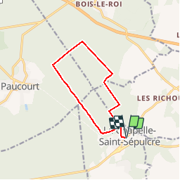
Randonnée Marche de 10,5 km à découvrir à Centre-Val de Loire, Loiret, La Chapelle-Saint-Sépulcre. Cette randonnée est proposée par Ordijamo45.
Description
Départ de l’église de La chapelle saint Sépulcre (45)
Parcourt de 10.5 km
partie de la route de la montagneuse en forêt de Montargis avec du dénivelé mais belle randonnée
Localisation
Pays :
France
Région :
Centre-Val de Loire
Département/Province :
Loiret
Commune :
La Chapelle-Saint-Sépulcre
Localité :
Unknown
Départ:(Dec)
Départ:(UTM)
488444 ; 5318332 (31U) N.
Commentaires
Randonnées à proximité
![Randonnée Marche Paucourt - Foret de Paucourt 1 - Photo](https://media.geolcdn.com/t/375/260/ext.jpg?maxdim=2&url=https%3A%2F%2Fstatic1.geolcdn.com%2Fsiteimages%2Fupload%2Ffiles%2F1553511878bg_sport_marche.png)
![Marche Marche](https://static1.geolcdn.com/sitytour/trail-icons/101.png)
Foret de Paucourt 1
Marche
Moyen
(1)
Paucourt,
Centre-Val de Loire,
Loiret,
France
![](/images/other/stat-length.png)
5,9 km | 6,9 km-effort
1h 30min
![](https://static1.geolcdn.com/siteimages/upload/files/16400158638029165_repeat_loop_refresh_sync_direction_icon.png)
Oui
![Randonnée Marche Paucourt - paucourt - Photo](https://media.geolcdn.com/t/375/260/0d5b98d1-99e8-401d-b110-67b014e8f009.jpg&format=jpg&maxdim=2)
![Marche Marche](https://static1.geolcdn.com/sitytour/trail-icons/101.png)
paucourt
Marche
Très facile
Paucourt,
Centre-Val de Loire,
Loiret,
France
![](/images/other/stat-length.png)
9 km | 9,9 km-effort
2h 7min
![](https://static1.geolcdn.com/siteimages/upload/files/16400158638029165_repeat_loop_refresh_sync_direction_icon.png)
Oui
![Randonnée Marche Paucourt - Autour de Paucourt - Photo](https://media.geolcdn.com/t/375/260/ext.jpg?maxdim=2&url=https%3A%2F%2Fstatic1.geolcdn.com%2Fsiteimages%2Fupload%2Ffiles%2F1553511878bg_sport_marche.png)
![Marche Marche](https://static1.geolcdn.com/sitytour/trail-icons/101.png)
Autour de Paucourt
Marche
Facile
Paucourt,
Centre-Val de Loire,
Loiret,
France
![](/images/other/stat-length.png)
12,7 km | 14,4 km-effort
3h 15min
![](https://static1.geolcdn.com/siteimages/upload/files/16400158638029165_repeat_loop_refresh_sync_direction_icon.png)
Oui
![Randonnée Marche Louzouer - les richoux - Photo](https://media.geolcdn.com/t/375/260/ext.jpg?maxdim=2&url=https%3A%2F%2Fstatic1.geolcdn.com%2Fsiteimages%2Fupload%2Ffiles%2F1553511878bg_sport_marche.png)
![Marche Marche](https://static1.geolcdn.com/sitytour/trail-icons/101.png)
les richoux
Marche
Très facile
Louzouer,
Centre-Val de Loire,
Loiret,
France
![](/images/other/stat-length.png)
37 km | 40 km-effort
3h 5min
![](https://static1.geolcdn.com/siteimages/upload/files/16400158638029165_repeat_loop_refresh_sync_direction_icon.png)
Non
![Randonnée Marche Paucourt - de Paucourt à St sépulcre et retour - Photo](https://media.geolcdn.com/t/375/260/ext.jpg?maxdim=2&url=https%3A%2F%2Fstatic1.geolcdn.com%2Fsiteimages%2Fupload%2Ffiles%2F1553511878bg_sport_marche.png)
![Marche Marche](https://static1.geolcdn.com/sitytour/trail-icons/101.png)
de Paucourt à St sépulcre et retour
Marche
Facile
Paucourt,
Centre-Val de Loire,
Loiret,
France
![](/images/other/stat-length.png)
8,2 km | 9,4 km-effort
2h 11min
![](https://static1.geolcdn.com/siteimages/upload/files/16400158638029165_repeat_loop_refresh_sync_direction_icon.png)
Oui
![Randonnée Marche Paucourt - Paucourt 45 12km5 Arle - Photo](https://media.geolcdn.com/t/375/260/ext.jpg?maxdim=2&url=https%3A%2F%2Fservices.sitytrail.com%2FGeolivesWS%2FDownloadMedia.ashx%3FTrailID%3D628237%26Media%3Dfix__20160908161703.jpg)
![Marche Marche](https://static1.geolcdn.com/sitytour/trail-icons/101.png)
Paucourt 45 12km5 Arle
Marche
Moyen
Paucourt,
Centre-Val de Loire,
Loiret,
France
![](/images/other/stat-length.png)
38 km | 42 km-effort
3h 17min
![](https://static1.geolcdn.com/siteimages/upload/files/16400158638029165_repeat_loop_refresh_sync_direction_icon.png)
Non
![Randonnée Marche Louzouer - Rando du menhir - Photo](https://media.geolcdn.com/t/375/260/ext.jpg?maxdim=2&url=https%3A%2F%2Fstatic1.geolcdn.com%2Fsiteimages%2Fupload%2Ffiles%2F1553511878bg_sport_marche.png)
![Marche Marche](https://static1.geolcdn.com/sitytour/trail-icons/101.png)
Rando du menhir
Marche
Facile
Louzouer,
Centre-Val de Loire,
Loiret,
France
![](/images/other/stat-length.png)
16,8 km | 18,9 km-effort
3h 5min
![](https://static1.geolcdn.com/siteimages/upload/files/16400158638029165_repeat_loop_refresh_sync_direction_icon.png)
Oui
![Randonnée Marche Paucourt - Foret de Paucourt 2 - Photo](https://media.geolcdn.com/t/375/260/ext.jpg?maxdim=2&url=https%3A%2F%2Fstatic1.geolcdn.com%2Fsiteimages%2Fupload%2Ffiles%2F1553511878bg_sport_marche.png)
![Marche Marche](https://static1.geolcdn.com/sitytour/trail-icons/101.png)
Foret de Paucourt 2
Marche
Moyen
Paucourt,
Centre-Val de Loire,
Loiret,
France
![](/images/other/stat-length.png)
7,9 km | 9,1 km-effort
1h 59min
![](https://static1.geolcdn.com/siteimages/upload/files/16400158638029165_repeat_loop_refresh_sync_direction_icon.png)
Oui
![Randonnée Marche Saint-Germain-des-Prés - montargis 01 - Photo](https://media.geolcdn.com/t/375/260/ext.jpg?maxdim=2&url=https%3A%2F%2Fstatic1.geolcdn.com%2Fsiteimages%2Fupload%2Ffiles%2F1553511878bg_sport_marche.png)
![Marche Marche](https://static1.geolcdn.com/sitytour/trail-icons/101.png)
montargis 01
Marche
Très facile
Saint-Germain-des-Prés,
Centre-Val de Loire,
Loiret,
France
![](/images/other/stat-length.png)
31 km | 34 km-effort
1h 33min
![](https://static1.geolcdn.com/siteimages/upload/files/16400158638029165_repeat_loop_refresh_sync_direction_icon.png)
Oui
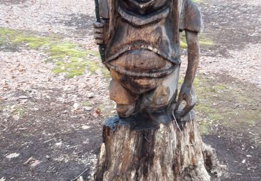
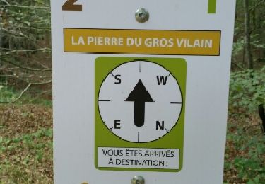
Nous voullions changer de la forêt de Fontainebleau. A recommencer... pas trop souvent ??