![](/images/other/stat-length.png)
![Randonnée Marche Salles - plavengut le lano allongée - Photo](https://media.geolcdn.com/t/1900/400/ext.pjpeg?maxdim=2&url=https%3A%2F%2Fstatic1.geolcdn.com%2Fsiteimages%2Fupload%2Ffiles%2F1553511878bg_sport_marche.png)
plavengut le lano allongée
emileverschueren
Utilisateur
![Longueur](/images/other/stat-length.png)
Longueur
7,2 km
![Altitude max](https://static1.geolcdn.com/siteimages/upload/files/1508320355ic_sort_altitude_max_24dp.png)
Altitude max
39 m
![Dénivelé positif](https://static1.geolcdn.com/siteimages/upload/files/1508320355ic_sort_den_pos_24dp.png)
Dénivelé positif
55 m
![Km-Effort](/images/other/stat-length.png)
Km-Effort
7,9 km
![Altitude min](https://static1.geolcdn.com/siteimages/upload/files/1508320355ic_sort_altitude_min_24dp.png)
Altitude min
15 m
![Dénivelé négatif](https://static1.geolcdn.com/siteimages/upload/files/1508320355ic_sort_den_neg_24dp.png)
Dénivelé négatif
55 m
![Boucle](https://static1.geolcdn.com/siteimages/upload/files/16400158638029165_repeat_loop_refresh_sync_direction_icon.png)
Boucle
Oui
Date de création :
2019-04-24 16:26:05.304
Dernière modification :
2019-04-24 16:26:05.35
![Marche](https://static1.geolcdn.com/sitytour/trail-icons/101.png)
2h05
Difficulté : Très facile
![Scannez ce code QR pour ouvrir la randonnée dans l'application SityTrail](https://capi.geolives.com/qq0zvz2zws4bq2lad0pu/sitytour/trails/742098/qr.png?size=200)
Application GPS de randonnée GRATUITE
À propos
Randonnée Marche de 7,2 km à découvrir à Nouvelle-Aquitaine, Gironde, Salles. Cette randonnée est proposée par emileverschueren.
Description
Le plus gros de la balade a été tracé par l' hôtesse de la chambre d'hôte PLAVENGUT qu'entre parenthèses nous conseillons vivement tant par sa situation géographique idéale que par l'accueil de notre hôte et le confort du lieu.
Localisation
Pays :
France
Région :
Nouvelle-Aquitaine
Département/Province :
Gironde
Commune :
Salles
Localité :
Unknown
Départ:(Dec)
Départ:(UTM)
668901 ; 4931494 (30T) N.
Commentaires
Randonnées à proximité
![Randonnée Marche Salles - Lanot, moulin de Moulon, Bilos - Photo](https://media.geolcdn.com/t/375/260/ext.jpg?maxdim=2&url=https%3A%2F%2Fstatic1.geolcdn.com%2Fsiteimages%2Fupload%2Ffiles%2F1553511878bg_sport_marche.png)
![Marche Marche](https://static1.geolcdn.com/sitytour/trail-icons/101.png)
Lanot, moulin de Moulon, Bilos
Marche
Très facile
(1)
Salles,
Nouvelle-Aquitaine,
Gironde,
France
![](/images/other/stat-length.png)
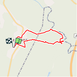
9,8 km | 11 km-effort
2h 50min
![](https://static1.geolcdn.com/siteimages/upload/files/16400158638029165_repeat_loop_refresh_sync_direction_icon.png)
Oui
![Randonnée sport Salles - Boucle route de la mole - Photo](https://media.geolcdn.com/t/375/260/ext.jpg?maxdim=2&url=https%3A%2F%2Fsecurestorage.geolives.com%2Fsitytour%2Ftrail-bg%2Fdefault.jpg)
Boucle route de la mole
sport
Très facile
(1)
Salles,
Nouvelle-Aquitaine,
Gironde,
France
![](/images/other/stat-length.png)
9,6 km | 10,5 km-effort
Inconnu
![](https://static1.geolcdn.com/siteimages/upload/files/16400158638029165_repeat_loop_refresh_sync_direction_icon.png)
Oui
![Randonnée V.T.C. Salles - Salles - De Salles à Belin-Béliet - Photo](https://media.geolcdn.com/t/375/260/01172f9e-c0a9-41f7-a2dd-20f5fb1b7995.jpg&format=jpg&maxdim=2)
![V.T.C. V.T.C.](https://static1.geolcdn.com/sitytour/trail-icons/203.png)
Salles - De Salles à Belin-Béliet
V.T.C.
Moyen
Salles,
Nouvelle-Aquitaine,
Gironde,
France
![](/images/other/stat-length.png)
19,4 km | 22 km-effort
2h 13min
![](https://static1.geolcdn.com/siteimages/upload/files/16400158638029165_repeat_loop_refresh_sync_direction_icon.png)
Non
![Randonnée Marche Salles - jour 1 - Photo](https://media.geolcdn.com/t/375/260/ext.jpg?maxdim=2&url=https%3A%2F%2Fstatic1.geolcdn.com%2Fsiteimages%2Fupload%2Ffiles%2F1553511878bg_sport_marche.png)
![Marche Marche](https://static1.geolcdn.com/sitytour/trail-icons/101.png)
jour 1
Marche
Très facile
(1)
Salles,
Nouvelle-Aquitaine,
Gironde,
France
![](/images/other/stat-length.png)
7,3 km | 8,1 km-effort
1h 32min
![](https://static1.geolcdn.com/siteimages/upload/files/16400158638029165_repeat_loop_refresh_sync_direction_icon.png)
Non
![Randonnée Marche Salles - j11 - Photo](https://media.geolcdn.com/t/375/260/ext.jpg?maxdim=2&url=https%3A%2F%2Fstatic1.geolcdn.com%2Fsiteimages%2Fupload%2Ffiles%2F1553511878bg_sport_marche.png)
![Marche Marche](https://static1.geolcdn.com/sitytour/trail-icons/101.png)
j11
Marche
Très facile
(1)
Salles,
Nouvelle-Aquitaine,
Gironde,
France
![](/images/other/stat-length.png)
6,3 km | 6,9 km-effort
1h 19min
![](https://static1.geolcdn.com/siteimages/upload/files/16400158638029165_repeat_loop_refresh_sync_direction_icon.png)
Oui
![Randonnée Marche Lugos - chapelle Saint Lugo - Photo](https://media.geolcdn.com/t/375/260/c0e66ab5-f691-4664-b528-db5f3cb32f16.jpg&format=jpg&maxdim=2)
![Marche Marche](https://static1.geolcdn.com/sitytour/trail-icons/101.png)
chapelle Saint Lugo
Marche
Difficile
Lugos,
Nouvelle-Aquitaine,
Gironde,
France
![](/images/other/stat-length.png)
12,1 km | 13,6 km-effort
3h 50min
![](https://static1.geolcdn.com/siteimages/upload/files/16400158638029165_repeat_loop_refresh_sync_direction_icon.png)
Oui
![Randonnée Marche Lugos - lugo - Photo](https://media.geolcdn.com/t/375/260/4e11623e-9d6c-4953-95d4-4ca70e7d8e3a.jpg&format=jpg&maxdim=2)
![Marche Marche](https://static1.geolcdn.com/sitytour/trail-icons/101.png)
lugo
Marche
Très facile
Lugos,
Nouvelle-Aquitaine,
Gironde,
France
![](/images/other/stat-length.png)
10,9 km | 12,2 km-effort
2h 21min
![](https://static1.geolcdn.com/siteimages/upload/files/16400158638029165_repeat_loop_refresh_sync_direction_icon.png)
Oui
![Randonnée Vélo électrique Salles - moto sillac - Photo](https://media.geolcdn.com/t/375/260/ext.jpg?maxdim=2&url=https%3A%2F%2Fstatic1.geolcdn.com%2Fsiteimages%2Fupload%2Ffiles%2F1524743154velo.jpg)
![Vélo électrique Vélo électrique](https://static1.geolcdn.com/sitytour/trail-icons/205.png)
moto sillac
Vélo électrique
Très facile
Salles,
Nouvelle-Aquitaine,
Gironde,
France
![](/images/other/stat-length.png)
29 km | 32 km-effort
1h 33min
![](https://static1.geolcdn.com/siteimages/upload/files/16400158638029165_repeat_loop_refresh_sync_direction_icon.png)
Non
![Randonnée Marche Lugos - Bran Vieux Lugo - Photo](https://media.geolcdn.com/t/375/260/ext.jpg?maxdim=2&url=https%3A%2F%2Fstatic1.geolcdn.com%2Fsiteimages%2Fupload%2Ffiles%2F1553511878bg_sport_marche.png)
![Marche Marche](https://static1.geolcdn.com/sitytour/trail-icons/101.png)
Bran Vieux Lugo
Marche
Moyen
Lugos,
Nouvelle-Aquitaine,
Gironde,
France
![](/images/other/stat-length.png)
10,4 km | 12 km-effort
3h 0min
![](https://static1.geolcdn.com/siteimages/upload/files/16400158638029165_repeat_loop_refresh_sync_direction_icon.png)
Oui