![](/images/other/stat-length.png)
![Randonnée Autre activité Dourbies - GR71 De l'Espérou (Gard) à Ceilhes-et-Rocozels (Hérault) (2016) - Photo](https://media.geolcdn.com/t/1900/400/ext.pjpeg?maxdim=2&url=https%3A%2F%2Fstatic1.geolcdn.com%2Fsiteimages%2Fupload%2Ffiles%2F1545311037marcheuse_200dpi.jpg)
GR71 De l'Espérou (Gard) à Ceilhes-et-Rocozels (Hérault) (2016)
leon40
Utilisateur
![Longueur](/images/other/stat-length.png)
Longueur
100 km
![Altitude max](https://static1.geolcdn.com/siteimages/upload/files/1508320355ic_sort_altitude_max_24dp.png)
Altitude max
1345 m
![Dénivelé positif](https://static1.geolcdn.com/siteimages/upload/files/1508320355ic_sort_den_pos_24dp.png)
Dénivelé positif
2161 m
![Km-Effort](/images/other/stat-length.png)
Km-Effort
132 km
![Altitude min](https://static1.geolcdn.com/siteimages/upload/files/1508320355ic_sort_altitude_min_24dp.png)
Altitude min
159 m
![Dénivelé négatif](https://static1.geolcdn.com/siteimages/upload/files/1508320355ic_sort_den_neg_24dp.png)
Dénivelé négatif
2943 m
![Boucle](https://static1.geolcdn.com/siteimages/upload/files/16400158638029165_repeat_loop_refresh_sync_direction_icon.png)
Boucle
Non
Date de création :
2018-04-16 12:35:45.802
Dernière modification :
2018-04-16 12:35:45.802
![Autre activité](https://static1.geolcdn.com/sitytour/trail-icons/900.png)
--
Difficulté : Inconnu
![Scannez ce code QR pour ouvrir la randonnée dans l'application SityTrail](https://capi.geolives.com/qq0zvz2zws4bq2lad0pu/sitytour/trails/736911/qr.png?size=200)
Application GPS de randonnée GRATUITE
À propos
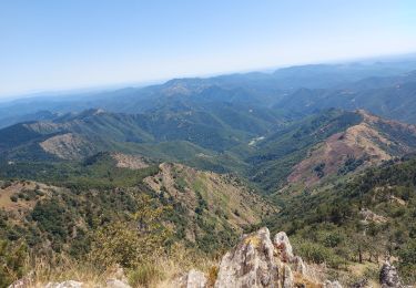
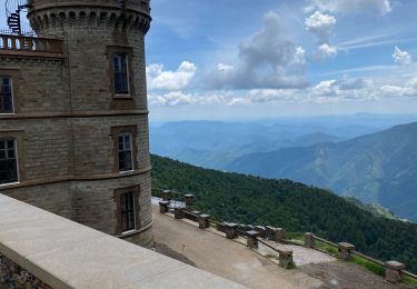
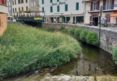
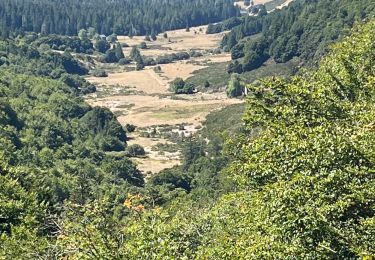
Randonnée Autre activité de 100 km à découvrir à Occitanie, Gard, Dourbies. Cette randonnée est proposée par leon40.
Description
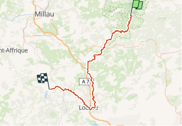
Randonnée avec le GR71 à travers le Gard, l'Aveyron et l'Hérault de l'Espérou à Ceilhes-et-Rocozels. Gîtes d'étapes, Chambres d'hôtes, Hôtels, Camping, Refuges, Auberges.
Localisation
Pays :
France
Région :
Occitanie
Département/Province :
Gard
Commune :
Dourbies
Localité :
Unknown
Départ:(Dec)
Départ:(UTM)
543796 ; 4882262 (31T) N.
Commentaires
Randonnées à proximité
![Randonnée Marche Arphy - Cascade d'Orgon/ monument André Chamson - Photo](https://media.geolcdn.com/t/375/260/e2360f77-e72b-40ce-8fc1-3dfbe5c83de1.jpg&format=jpg&maxdim=2)
![Marche Marche](https://static1.geolcdn.com/sitytour/trail-icons/101.png)
Cascade d'Orgon/ monument André Chamson
Marche
Moyen
Arphy,
Occitanie,
Gard,
France
![](/images/other/stat-length.png)
13,9 km | 19,6 km-effort
5h 45min
![](https://static1.geolcdn.com/siteimages/upload/files/16400158638029165_repeat_loop_refresh_sync_direction_icon.png)
Oui
![Randonnée Marche Val-d'Aigoual - col de la Lusette - Pic de Barette - col de Montals - L'Espérou - Photo](https://media.geolcdn.com/t/375/260/ext.jpg?maxdim=2&url=https%3A%2F%2Fstatic1.geolcdn.com%2Fsiteimages%2Fupload%2Ffiles%2F1553511878bg_sport_marche.png)
![Marche Marche](https://static1.geolcdn.com/sitytour/trail-icons/101.png)
col de la Lusette - Pic de Barette - col de Montals - L'Espérou
Marche
Moyen
(1)
Val-d'Aigoual,
Occitanie,
Gard,
France
![](/images/other/stat-length.png)
17,6 km | 23 km-effort
4h 56min
![](https://static1.geolcdn.com/siteimages/upload/files/16400158638029165_repeat_loop_refresh_sync_direction_icon.png)
Oui
![Randonnée Marche Meyrueis - Bois de la Dauphine - Photo](https://media.geolcdn.com/t/375/260/a7cc8742-6cf3-4cba-a6a2-d1c0486babc2.jpg&format=jpg&maxdim=2)
![Marche Marche](https://static1.geolcdn.com/sitytour/trail-icons/101.png)
Bois de la Dauphine
Marche
Moyen
Meyrueis,
Occitanie,
Lozère,
France
![](/images/other/stat-length.png)
8 km | 9,8 km-effort
2h 52min
![](https://static1.geolcdn.com/siteimages/upload/files/16400158638029165_repeat_loop_refresh_sync_direction_icon.png)
Non
![Randonnée Marche Val-d'Aigoual - les cascades de l'aigoual par seyrerede - Photo](https://media.geolcdn.com/t/375/260/f9837145-dbac-42c7-abcf-7cbb3f01b62c.jpg&format=jpg&maxdim=2)
![Marche Marche](https://static1.geolcdn.com/sitytour/trail-icons/101.png)
les cascades de l'aigoual par seyrerede
Marche
Moyen
Val-d'Aigoual,
Occitanie,
Gard,
France
![](/images/other/stat-length.png)
19,7 km | 27 km-effort
6h 29min
![](https://static1.geolcdn.com/siteimages/upload/files/16400158638029165_repeat_loop_refresh_sync_direction_icon.png)
Oui
![Randonnée Marche Val-d'Aigoual - serreyrede à l aigoual par arboretum - Photo](https://media.geolcdn.com/t/375/260/2be9adc5-67d2-49de-acda-0293aa7a92e9.jpg&format=jpg&maxdim=2)
![Marche Marche](https://static1.geolcdn.com/sitytour/trail-icons/101.png)
serreyrede à l aigoual par arboretum
Marche
Facile
Val-d'Aigoual,
Occitanie,
Gard,
France
![](/images/other/stat-length.png)
20 km | 28 km-effort
7h 13min
![](https://static1.geolcdn.com/siteimages/upload/files/16400158638029165_repeat_loop_refresh_sync_direction_icon.png)
Oui
![Randonnée Marche Val-d'Aigoual - Serreyrede-caumette-Pra peyrot - Photo](https://media.geolcdn.com/t/375/260/4bd7c368-ffdb-4e2f-8b71-be78c10adff8.jpg&format=jpg&maxdim=2)
![Marche Marche](https://static1.geolcdn.com/sitytour/trail-icons/101.png)
Serreyrede-caumette-Pra peyrot
Marche
Moyen
Val-d'Aigoual,
Occitanie,
Gard,
France
![](/images/other/stat-length.png)
7,7 km | 10,2 km-effort
2h 18min
![](https://static1.geolcdn.com/siteimages/upload/files/16400158638029165_repeat_loop_refresh_sync_direction_icon.png)
Oui
![Randonnée Marche Bassurels - Mont Aigoual Meyrues - Photo](https://media.geolcdn.com/t/375/260/6ddc0c7f-3198-46c8-9615-a233dbac5c7f.jpg&format=jpg&maxdim=2)
![Marche Marche](https://static1.geolcdn.com/sitytour/trail-icons/101.png)
Mont Aigoual Meyrues
Marche
Très difficile
Bassurels,
Occitanie,
Lozère,
France
![](/images/other/stat-length.png)
37 km | 53 km-effort
11h 50min
![](https://static1.geolcdn.com/siteimages/upload/files/16400158638029165_repeat_loop_refresh_sync_direction_icon.png)
Oui
![Randonnée Marche Bassurels - Observatoire Mont Aigoual / Meyrueis - Photo](https://media.geolcdn.com/t/375/260/12e8418a-66c5-46a2-8d87-f4dcc8a1a26c.jpg&format=jpg&maxdim=2)
![Marche Marche](https://static1.geolcdn.com/sitytour/trail-icons/101.png)
Observatoire Mont Aigoual / Meyrueis
Marche
Moyen
Bassurels,
Occitanie,
Lozère,
France
![](/images/other/stat-length.png)
16,7 km | 22 km-effort
4h 44min
![](https://static1.geolcdn.com/siteimages/upload/files/16400158638029165_repeat_loop_refresh_sync_direction_icon.png)
Non
![Randonnée Marche Val-d'Aigoual - PLO de VALBELLE - Photo](https://media.geolcdn.com/t/375/260/5c0bf513-bea3-4d2c-8dc7-aabb01646242.jpg&format=jpg&maxdim=2)
![Marche Marche](https://static1.geolcdn.com/sitytour/trail-icons/101.png)
PLO de VALBELLE
Marche
Difficile
Val-d'Aigoual,
Occitanie,
Gard,
France
![](/images/other/stat-length.png)
13,9 km | 18,5 km-effort
5h 44min
![](https://static1.geolcdn.com/siteimages/upload/files/16400158638029165_repeat_loop_refresh_sync_direction_icon.png)
Oui