![](/images/other/stat-length.png)
![Randonnée Marche Carnoules - Carnoules Les Thèmes projet 2 - Photo](https://media.geolcdn.com/t/1900/400/ext.pjpeg?maxdim=2&url=https%3A%2F%2Fstatic1.geolcdn.com%2Fsiteimages%2Fupload%2Ffiles%2F1553511878bg_sport_marche.png)
Carnoules Les Thèmes projet 2
Sugg
Utilisateur
![Longueur](/images/other/stat-length.png)
Longueur
18,3 km
![Altitude max](https://static1.geolcdn.com/siteimages/upload/files/1508320355ic_sort_altitude_max_24dp.png)
Altitude max
537 m
![Dénivelé positif](https://static1.geolcdn.com/siteimages/upload/files/1508320355ic_sort_den_pos_24dp.png)
Dénivelé positif
437 m
![Km-Effort](/images/other/stat-length.png)
Km-Effort
24 km
![Altitude min](https://static1.geolcdn.com/siteimages/upload/files/1508320355ic_sort_altitude_min_24dp.png)
Altitude min
274 m
![Dénivelé négatif](https://static1.geolcdn.com/siteimages/upload/files/1508320355ic_sort_den_neg_24dp.png)
Dénivelé négatif
432 m
![Boucle](https://static1.geolcdn.com/siteimages/upload/files/16400158638029165_repeat_loop_refresh_sync_direction_icon.png)
Boucle
Oui
Date de création :
2019-03-22 16:58:29.67
Dernière modification :
2019-03-22 16:58:29.726
![Marche](https://static1.geolcdn.com/sitytour/trail-icons/101.png)
5h00
Difficulté : Moyen
![Scannez ce code QR pour ouvrir la randonnée dans l'application SityTrail](https://capi.geolives.com/qq0zvz2zws4bq2lad0pu/sitytour/trails/735409/qr.png?size=200)
Application GPS de randonnée GRATUITE
À propos
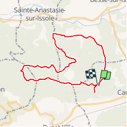
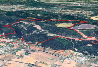
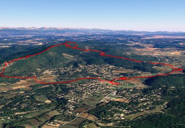
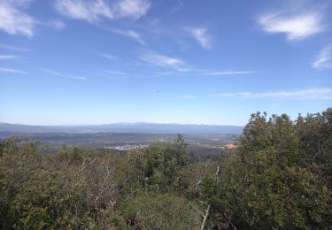
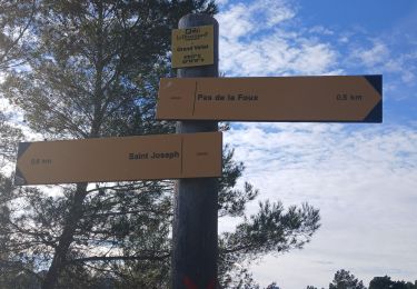
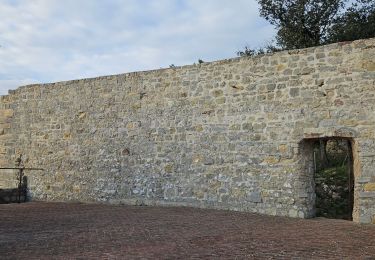
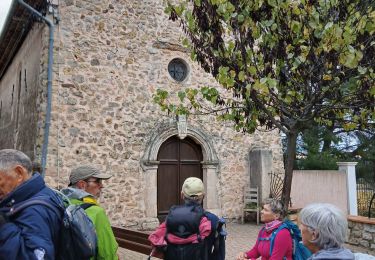
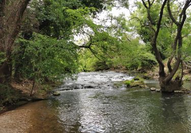
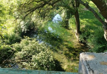
Randonnée Marche de 18,3 km à découvrir à Provence-Alpes-Côte d'Azur, Var, Carnoules. Cette randonnée est proposée par Sugg.
Description
Pour rando du 19-04-17.
Suite changement du lieu de départ ( voir Carnoules trou du Bœuf projet 1 et reco du 14-04-17.), nouvel itinéraire, suppression de la boucle du Roucas.
Localisation
Pays :
France
Région :
Provence-Alpes-Côte d'Azur
Département/Province :
Var
Commune :
Carnoules
Localité :
Unknown
Départ:(Dec)
Départ:(UTM)
270161 ; 4798652 (32T) N.
Commentaires
Randonnées à proximité
![Randonnée Marche Puget-Ville - Tour du faucon - Colle de Terre Blanche - Pas de la Foux - Chapelle de la Viere - Photo](https://media.geolcdn.com/t/375/260/a439650a-cafa-4b8d-9956-721100a033df.jpg&format=jpg&maxdim=2)
![Marche Marche](https://static1.geolcdn.com/sitytour/trail-icons/101.png)
Tour du faucon - Colle de Terre Blanche - Pas de la Foux - Chapelle de la Viere
Marche
Moyen
(1)
Puget-Ville,
Provence-Alpes-Côte d'Azur,
Var,
France
![](/images/other/stat-length.png)
14,1 km | 19,6 km-effort
6h 0min
![](https://static1.geolcdn.com/siteimages/upload/files/16400158638029165_repeat_loop_refresh_sync_direction_icon.png)
Oui
![Randonnée Marche Sainte-Anastasie-sur-Issole - Départ Ste Anastasie - Grotte de gaspard de Besse - Chapelle de St Quinis - Barres de St Quinis - Photo](https://media.geolcdn.com/t/375/260/855ac779-a3c7-4759-9622-72ff9450b7e1.jpg&format=jpg&maxdim=2)
![Marche Marche](https://static1.geolcdn.com/sitytour/trail-icons/101.png)
Départ Ste Anastasie - Grotte de gaspard de Besse - Chapelle de St Quinis - B...
Marche
Moyen
(2)
Sainte-Anastasie-sur-Issole,
Provence-Alpes-Côte d'Azur,
Var,
France
![](/images/other/stat-length.png)
11,8 km | 17,6 km-effort
6h 0min
![](https://static1.geolcdn.com/siteimages/upload/files/16400158638029165_repeat_loop_refresh_sync_direction_icon.png)
Oui
![Randonnée Marche Sainte-Anastasie-sur-Issole - St Anastasie St Quinis 2 - Photo](https://media.geolcdn.com/t/375/260/ext.jpg?maxdim=2&url=https%3A%2F%2Fservices.sitytrail.com%2FGeolivesWS%2FDownloadMedia.ashx%3FTrailID%3D901213%26Media%3Dfix__20180207101706.jpg)
![Marche Marche](https://static1.geolcdn.com/sitytour/trail-icons/101.png)
St Anastasie St Quinis 2
Marche
Moyen
(1)
Sainte-Anastasie-sur-Issole,
Provence-Alpes-Côte d'Azur,
Var,
France
![](/images/other/stat-length.png)
13,5 km | 19,4 km-effort
4h 7min
![](https://static1.geolcdn.com/siteimages/upload/files/16400158638029165_repeat_loop_refresh_sync_direction_icon.png)
Oui
![Randonnée Marche Besse-sur-Issole - Ermitage de Saint Quinis 16.3.24 - Photo](https://media.geolcdn.com/t/375/260/dc71aa2c-2a52-4e81-901f-c8126950b626.jpg&format=jpg&maxdim=2)
![Marche Marche](https://static1.geolcdn.com/sitytour/trail-icons/101.png)
Ermitage de Saint Quinis 16.3.24
Marche
Facile
Besse-sur-Issole,
Provence-Alpes-Côte d'Azur,
Var,
France
![](/images/other/stat-length.png)
10 km | 15,2 km-effort
3h 0min
![](https://static1.geolcdn.com/siteimages/upload/files/16400158638029165_repeat_loop_refresh_sync_direction_icon.png)
Oui
![Randonnée Marche Puget-Ville - ND de la Vière Puget ville 24-01-2025 - Photo](https://media.geolcdn.com/t/375/260/65daf1f6-5c8e-441d-a7ff-dae9a4950388.jpg&format=jpg&maxdim=2)
![Marche Marche](https://static1.geolcdn.com/sitytour/trail-icons/101.png)
ND de la Vière Puget ville 24-01-2025
Marche
Moyen
Puget-Ville,
Provence-Alpes-Côte d'Azur,
Var,
France
![](/images/other/stat-length.png)
8,9 km | 11,8 km-effort
2h 9min
![](https://static1.geolcdn.com/siteimages/upload/files/16400158638029165_repeat_loop_refresh_sync_direction_icon.png)
Oui
![Randonnée Marche Puget-Ville - Puget-ville Sainte Philomène - Photo](https://media.geolcdn.com/t/375/260/2dc2febd-ae0c-4426-b6da-cece7743c366.jpg&format=jpg&maxdim=2)
![Marche Marche](https://static1.geolcdn.com/sitytour/trail-icons/101.png)
Puget-ville Sainte Philomène
Marche
Difficile
Puget-Ville,
Provence-Alpes-Côte d'Azur,
Var,
France
![](/images/other/stat-length.png)
11,1 km | 15,4 km-effort
4h 52min
![](https://static1.geolcdn.com/siteimages/upload/files/16400158638029165_repeat_loop_refresh_sync_direction_icon.png)
Oui
![Randonnée Marche Puget-Ville - Les Thèmes- Puget V. 20-11-2024 - Photo](https://media.geolcdn.com/t/375/260/e23e0561-9bb1-480a-87fa-d75c7dbb0cad.jpg&format=jpg&maxdim=2)
![Marche Marche](https://static1.geolcdn.com/sitytour/trail-icons/101.png)
Les Thèmes- Puget V. 20-11-2024
Marche
Moyen
Puget-Ville,
Provence-Alpes-Côte d'Azur,
Var,
France
![](/images/other/stat-length.png)
19,3 km | 28 km-effort
5h 2min
![](https://static1.geolcdn.com/siteimages/upload/files/16400158638029165_repeat_loop_refresh_sync_direction_icon.png)
Oui
![Randonnée Marche Besse-sur-Issole - Boucle entre Besse et Ste Anastasie sur Issole - Photo](https://media.geolcdn.com/t/375/260/06e3e46b-800e-4c1c-9551-df99b428495c.jpg&format=jpg&maxdim=2)
![Marche Marche](https://static1.geolcdn.com/sitytour/trail-icons/101.png)
Boucle entre Besse et Ste Anastasie sur Issole
Marche
Moyen
Besse-sur-Issole,
Provence-Alpes-Côte d'Azur,
Var,
France
![](/images/other/stat-length.png)
14,8 km | 18,9 km-effort
4h 17min
![](https://static1.geolcdn.com/siteimages/upload/files/16400158638029165_repeat_loop_refresh_sync_direction_icon.png)
Oui
![Randonnée Marche Sainte-Anastasie-sur-Issole - Les Ribas-la Clape - Photo](https://media.geolcdn.com/t/375/260/7e0b258a-94e3-48f6-911c-8fa6347d6a29.jpg&format=jpg&maxdim=2)
![Marche Marche](https://static1.geolcdn.com/sitytour/trail-icons/101.png)
Les Ribas-la Clape
Marche
Moyen
Sainte-Anastasie-sur-Issole,
Provence-Alpes-Côte d'Azur,
Var,
France
![](/images/other/stat-length.png)
6,3 km | 8,1 km-effort
1h 54min
![](https://static1.geolcdn.com/siteimages/upload/files/16400158638029165_repeat_loop_refresh_sync_direction_icon.png)
Oui