![](/images/other/stat-length.png)
![Randonnée Marche Houyet - CELLES (Foy N-Dame) - Photo](https://media.geolcdn.com/t/1900/400/ext.pjpeg?maxdim=2&url=https%3A%2F%2Fservices.sitytrail.com%2FGeolivesWS%2FDownloadMedia.ashx%3FTrailID%3D732251%26Media%3Dfix__20170413132918.jpg)
CELLES (Foy N-Dame)
GerardBouche
Utilisateur
![Longueur](/images/other/stat-length.png)
Longueur
10,1 km
![Altitude max](https://static1.geolcdn.com/siteimages/upload/files/1508320355ic_sort_altitude_max_24dp.png)
Altitude max
293 m
![Dénivelé positif](https://static1.geolcdn.com/siteimages/upload/files/1508320355ic_sort_den_pos_24dp.png)
Dénivelé positif
265 m
![Km-Effort](/images/other/stat-length.png)
Km-Effort
13,4 km
![Altitude min](https://static1.geolcdn.com/siteimages/upload/files/1508320355ic_sort_altitude_min_24dp.png)
Altitude min
186 m
![Dénivelé négatif](https://static1.geolcdn.com/siteimages/upload/files/1508320355ic_sort_den_neg_24dp.png)
Dénivelé négatif
200 m
![Boucle](https://static1.geolcdn.com/siteimages/upload/files/16400158638029165_repeat_loop_refresh_sync_direction_icon.png)
Boucle
Non
Date de création :
2017-04-14 00:00:00.0
Dernière modification :
2017-04-14 00:00:00.0
![Marche](https://static1.geolcdn.com/sitytour/trail-icons/101.png)
3h07
Difficulté : Facile
![Scannez ce code QR pour ouvrir la randonnée dans l'application SityTrail](https://capi.geolives.com/qq0zvz2zws4bq2lad0pu/sitytour/trails/732251/qr.png?size=200)
Application GPS de randonnée GRATUITE
À propos
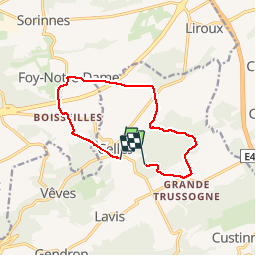
Randonnée Marche de 10,1 km à découvrir à Wallonie, Namur, Houyet. Cette randonnée est proposée par GerardBouche.
Description
Un des plus beaux villages de Wallonie ... au départ de la place de l'église St-Hadelin par le bois de Coreu, le lieu dit Hubaille, la ferme de Mahenne et le village de Foy-Notre-Dame. (SityTrail à cessé de fonctionner 1km avant l'arrivée)
Localisation
Pays :
Belgique
Région :
Wallonie
Département/Province :
Namur
Commune :
Houyet
Localité :
Celles
Départ:(Dec)
Départ:(UTM)
643204 ; 5566029 (31U) N.
Commentaires
Randonnées à proximité
![Randonnée Marche Houyet - Nature - Promenade de Payenne - VTT - Photo](https://media.geolcdn.com/t/375/260/ext.jpg?maxdim=2&url=https%3A%2F%2Fservices.sitytrail.com%2FGeolivesWS%2FDownloadMedia.ashx%3FTrailID%3D247221%26Media%3D4a1116e4-3cc3-4f81-a279-87cb261b0cef.jpg)
![Marche Marche](https://static1.geolcdn.com/sitytour/trail-icons/101.png)
Nature - Promenade de Payenne - VTT
Marche
Difficile
(5)
Houyet,
Wallonie,
Namur,
Belgique
![](/images/other/stat-length.png)
14,3 km | 19 km-effort
4h 18min
![](https://static1.geolcdn.com/siteimages/upload/files/16400158638029165_repeat_loop_refresh_sync_direction_icon.png)
Oui
![Randonnée Marche Houyet - Nature - Promenade du Parc d'Ardenne à Houyet - Photo](https://media.geolcdn.com/t/375/260/ext.jpg?maxdim=2&url=https%3A%2F%2Fservices.sitytrail.com%2FGeolivesWS%2FDownloadMedia.ashx%3FTrailID%3D193546%26Media%3D0a2a8593-cf69-475f-a9b0-b2a4af4f959b.jpg)
![Marche Marche](https://static1.geolcdn.com/sitytour/trail-icons/101.png)
Nature - Promenade du Parc d'Ardenne à Houyet
Marche
Difficile
(14)
Houyet,
Wallonie,
Namur,
Belgique
![](/images/other/stat-length.png)
5,7 km | 7,8 km-effort
1h 47min
![](https://static1.geolcdn.com/siteimages/upload/files/16400158638029165_repeat_loop_refresh_sync_direction_icon.png)
Oui
![Randonnée Marche Houyet - Houyet - Nature - Pî-sinte po tortos - Pédestre, cyclo, équestre, PMR - Photo](https://media.geolcdn.com/t/375/260/ext.jpg?maxdim=2&url=https%3A%2F%2Fservices.sitytrail.com%2FGeolivesWS%2FDownloadMedia.ashx%3FTrailID%3D193539%26Media%3D6b85272b-deee-4a79-9526-05b6bf74491c.jpg)
![Marche Marche](https://static1.geolcdn.com/sitytour/trail-icons/101.png)
Houyet - Nature - Pî-sinte po tortos - Pédestre, cyclo, équestre, PMR
Marche
(6)
Houyet,
Wallonie,
Namur,
Belgique
![](/images/other/stat-length.png)
4,3 km | 4,9 km-effort
1h 0min
![](https://static1.geolcdn.com/siteimages/upload/files/16400158638029165_repeat_loop_refresh_sync_direction_icon.png)
Oui
![Randonnée Marche Houyet - La Lesse, Natura 2000 - Des sites qui valent le détour, Na07 - Photo](https://media.geolcdn.com/t/375/260/ext.jpg?maxdim=2&url=https%3A%2F%2Fservices.sitytrail.com%2FGeolivesWS%2FDownloadMedia.ashx%3FTrailID%3D188163%26Media%3Df0b29f0e-e19a-4fa8-a869-5ab27b1769d7.JPG)
![Marche Marche](https://static1.geolcdn.com/sitytour/trail-icons/101.png)
La Lesse, Natura 2000 - Des sites qui valent le détour, Na07
Marche
Difficile
(9)
Houyet,
Wallonie,
Namur,
Belgique
![](/images/other/stat-length.png)
8,8 km | 11,5 km-effort
2h 33min
![](https://static1.geolcdn.com/siteimages/upload/files/16400158638029165_repeat_loop_refresh_sync_direction_icon.png)
Oui
![Randonnée Marche Houyet - RB-Na-05-Celles - Photo](https://media.geolcdn.com/t/375/260/ext.jpg?maxdim=2&url=https%3A%2F%2Fservices.sitytrail.com%2FGeolivesWS%2FDownloadMedia.ashx%3FTrailID%3D179631%26Media%3D95d7547e-2b07-4681-8a2a-4a37901ae9c7.jpg)
![Marche Marche](https://static1.geolcdn.com/sitytour/trail-icons/101.png)
RB-Na-05-Celles
Marche
Moyen
(9)
Houyet,
Wallonie,
Namur,
Belgique
![](/images/other/stat-length.png)
24 km | 31 km-effort
6h 33min
![](https://static1.geolcdn.com/siteimages/upload/files/16400158638029165_repeat_loop_refresh_sync_direction_icon.png)
Oui
![Randonnée Marche Houyet - Nature - Houyet, commune royale - Photo](https://media.geolcdn.com/t/375/260/ext.jpg?maxdim=2&url=https%3A%2F%2Fservices.sitytrail.com%2FGeolivesWS%2FDownloadMedia.ashx%3FTrailID%3D166040%26Media%3D0a2a8593-cf69-475f-a9b0-b2a4af4f959b.jpg)
![Marche Marche](https://static1.geolcdn.com/sitytour/trail-icons/101.png)
Nature - Houyet, commune royale
Marche
Difficile
(14)
Houyet,
Wallonie,
Namur,
Belgique
![](/images/other/stat-length.png)
8,3 km | 11,5 km-effort
2h 33min
![](https://static1.geolcdn.com/siteimages/upload/files/16400158638029165_repeat_loop_refresh_sync_direction_icon.png)
Oui
![Randonnée Marche Houyet - RB-Na-05_Celles_via-racc-1 - Photo](https://media.geolcdn.com/t/375/260/ext.jpg?maxdim=2&url=https%3A%2F%2Fservices.sitytrail.com%2FGeolivesWS%2FDownloadMedia.ashx%3FTrailID%3D213753%26Media%3D8bab1d47-4651-4050-8b88-78bf90d52eb5.jpg)
![Marche Marche](https://static1.geolcdn.com/sitytour/trail-icons/101.png)
RB-Na-05_Celles_via-racc-1
Marche
Facile
(5)
Houyet,
Wallonie,
Namur,
Belgique
![](/images/other/stat-length.png)
21 km | 26 km-effort
5h 37min
![](https://static1.geolcdn.com/siteimages/upload/files/16400158638029165_repeat_loop_refresh_sync_direction_icon.png)
Oui
![Randonnée Marche Houyet - Nature & patrimoine à Celles, un des Plus Beaux Villages de Wallonie - Photo](https://media.geolcdn.com/t/375/260/ac9d387c-3f8d-401d-bffe-044b71ce3eff.jpg&format=jpg&maxdim=2)
![Marche Marche](https://static1.geolcdn.com/sitytour/trail-icons/101.png)
Nature & patrimoine à Celles, un des Plus Beaux Villages de Wallonie
Marche
Moyen
(6)
Houyet,
Wallonie,
Namur,
Belgique
![](/images/other/stat-length.png)
9,6 km | 12,7 km-effort
2h 52min
![](https://static1.geolcdn.com/siteimages/upload/files/16400158638029165_repeat_loop_refresh_sync_direction_icon.png)
Oui
![Randonnée Marche Houyet - Nature et patrimoine - Promenade du Château de Vêves - Photo](https://media.geolcdn.com/t/375/260/ext.jpg?maxdim=2&url=https%3A%2F%2Fservices.sitytrail.com%2FGeolivesWS%2FDownloadMedia.ashx%3FTrailID%3D193554%26Media%3D89a5bf6a-392e-4b4e-aa1f-d6a80dc2ba50.JPG)
![Marche Marche](https://static1.geolcdn.com/sitytour/trail-icons/101.png)
Nature et patrimoine - Promenade du Château de Vêves
Marche
Moyen
(6)
Houyet,
Wallonie,
Namur,
Belgique
![](/images/other/stat-length.png)
6,4 km | 8,7 km-effort
1h 49min
![](https://static1.geolcdn.com/siteimages/upload/files/16400158638029165_repeat_loop_refresh_sync_direction_icon.png)
Oui