![](/images/other/stat-length.png)
![Randonnée Marche La Baume-Cornillane - F26120_la_Baume_C._pas_de_la_Croix_CG - Photo](https://media.geolcdn.com/t/1900/400/ext.pjpeg?maxdim=2&url=https%3A%2F%2Fstatic1.geolcdn.com%2Fsiteimages%2Fupload%2Ffiles%2F1553511878bg_sport_marche.png)
F26120_la_Baume_C._pas_de_la_Croix_CG
ageo
Utilisateur
![Longueur](/images/other/stat-length.png)
Longueur
12,6 km
![Altitude max](https://static1.geolcdn.com/siteimages/upload/files/1508320355ic_sort_altitude_max_24dp.png)
Altitude max
921 m
![Dénivelé positif](https://static1.geolcdn.com/siteimages/upload/files/1508320355ic_sort_den_pos_24dp.png)
Dénivelé positif
710 m
![Km-Effort](/images/other/stat-length.png)
Km-Effort
22 km
![Altitude min](https://static1.geolcdn.com/siteimages/upload/files/1508320355ic_sort_altitude_min_24dp.png)
Altitude min
315 m
![Dénivelé négatif](https://static1.geolcdn.com/siteimages/upload/files/1508320355ic_sort_den_neg_24dp.png)
Dénivelé négatif
708 m
![Boucle](https://static1.geolcdn.com/siteimages/upload/files/16400158638029165_repeat_loop_refresh_sync_direction_icon.png)
Boucle
Oui
Date de création :
2017-06-09 00:00:00.0
Dernière modification :
2017-06-09 00:00:00.0
![Marche](https://static1.geolcdn.com/sitytour/trail-icons/101.png)
4h35
Difficulté : Moyen
![Scannez ce code QR pour ouvrir la randonnée dans l'application SityTrail](https://capi.geolives.com/qq0zvz2zws4bq2lad0pu/sitytour/trails/728400/qr.png?size=200)
Application GPS de randonnée GRATUITE
À propos
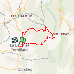
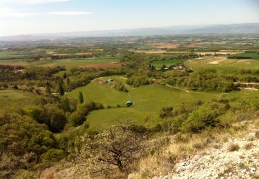
Randonnée Marche de 12,6 km à découvrir à Auvergne-Rhône-Alpes, Drôme, La Baume-Cornillane. Cette randonnée est proposée par ageo.
Description
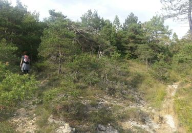
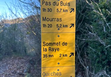
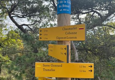
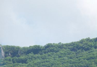
Très belle vue dur le Vercors grâce à l'aller retour après le pas de la Croix. Nous avons fait un peu les sangliers au niveau de Serre Perrier après la source captée. Il vaut mieux prendre le sentier à gauche.
Localisation
Pays :
France
Région :
Auvergne-Rhône-Alpes
Département/Province :
Drôme
Commune :
La Baume-Cornillane
Localité :
Unknown
Départ:(Dec)
Départ:(UTM)
661197 ; 4965393 (31T) N.
Commentaires
Randonnées à proximité
![Randonnée Marche Barcelonne - Barcelonne - autour de la Tour - Description et photos - Photo](https://media.geolcdn.com/t/375/260/ext.jpg?maxdim=2&url=https%3A%2F%2Fservices.sitytrail.com%2FGeolivesWS%2FDownloadMedia.ashx%3FTrailID%3D639966%26Media%3Dfix__20161002163239.jpg)
![Marche Marche](https://static1.geolcdn.com/sitytour/trail-icons/101.png)
Barcelonne - autour de la Tour - Description et photos
Marche
Facile
(3)
Barcelonne,
Auvergne-Rhône-Alpes,
Drôme,
France
![](/images/other/stat-length.png)
4,3 km | 6,6 km-effort
1h 29min
![](https://static1.geolcdn.com/siteimages/upload/files/16400158638029165_repeat_loop_refresh_sync_direction_icon.png)
Oui
![Randonnée Marche Barcelonne - Barcelonne-Combivin-Chapelle St Marguerite - Photo](https://media.geolcdn.com/t/375/260/ext.jpg?maxdim=2&url=https%3A%2F%2Fservices.sitytrail.com%2FGeolivesWS%2FDownloadMedia.ashx%3FTrailID%3D272339%26Media%3D20140430171101.jpg)
![Marche Marche](https://static1.geolcdn.com/sitytour/trail-icons/101.png)
Barcelonne-Combivin-Chapelle St Marguerite
Marche
Facile
(1)
Barcelonne,
Auvergne-Rhône-Alpes,
Drôme,
France
![](/images/other/stat-length.png)
8,7 km | 13,5 km-effort
2h 20min
![](https://static1.geolcdn.com/siteimages/upload/files/16400158638029165_repeat_loop_refresh_sync_direction_icon.png)
Oui
![Randonnée Marche La Baume-Cornillane - Pas du Pont - Pas de la Croix - Pas du Buis - Photo](https://media.geolcdn.com/t/375/260/ext.jpg?maxdim=2&url=https%3A%2F%2Fservices.sitytrail.com%2FGeolivesWS%2FDownloadMedia.ashx%3FTrailID%3D99687%26Media%3D20120128162324.jpeg)
![Marche Marche](https://static1.geolcdn.com/sitytour/trail-icons/101.png)
Pas du Pont - Pas de la Croix - Pas du Buis
Marche
Moyen
(2)
La Baume-Cornillane,
Auvergne-Rhône-Alpes,
Drôme,
France
![](/images/other/stat-length.png)
10,3 km | 18 km-effort
2h 52min
![](https://static1.geolcdn.com/siteimages/upload/files/16400158638029165_repeat_loop_refresh_sync_direction_icon.png)
Oui
![Randonnée Marche Gigors-et-Lozeron - 26 st supporte gigors - Photo](https://media.geolcdn.com/t/375/260/c169c5cd-1ed9-4b41-908c-c962ab944e47.jpg&format=jpg&maxdim=2)
![Marche Marche](https://static1.geolcdn.com/sitytour/trail-icons/101.png)
26 st supporte gigors
Marche
Moyen
Gigors-et-Lozeron,
Auvergne-Rhône-Alpes,
Drôme,
France
![](/images/other/stat-length.png)
16 km | 24 km-effort
5h 8min
![](https://static1.geolcdn.com/siteimages/upload/files/16400158638029165_repeat_loop_refresh_sync_direction_icon.png)
Oui
![Randonnée Marche La Baume-Cornillane - pas du pont - Photo](https://media.geolcdn.com/t/375/260/ext.jpg?maxdim=2&url=https%3A%2F%2Fstatic1.geolcdn.com%2Fsiteimages%2Fupload%2Ffiles%2F1553511878bg_sport_marche.png)
![Marche Marche](https://static1.geolcdn.com/sitytour/trail-icons/101.png)
pas du pont
Marche
Facile
(1)
La Baume-Cornillane,
Auvergne-Rhône-Alpes,
Drôme,
France
![](/images/other/stat-length.png)
6,9 km | 9,8 km-effort
3h 22min
![](https://static1.geolcdn.com/siteimages/upload/files/16400158638029165_repeat_loop_refresh_sync_direction_icon.png)
Oui
![Randonnée sport La Baume-Cornillane - La Baume Cornillane La Raye - Photo](https://media.geolcdn.com/t/375/260/7f63db71-820f-4a5b-bce7-d0b5098b2eb0.jpg&format=jpg&maxdim=2)
La Baume Cornillane La Raye
sport
Très facile
La Baume-Cornillane,
Auvergne-Rhône-Alpes,
Drôme,
France
![](/images/other/stat-length.png)
15,5 km | 27 km-effort
Inconnu
![](https://static1.geolcdn.com/siteimages/upload/files/16400158638029165_repeat_loop_refresh_sync_direction_icon.png)
Oui
![Randonnée sport Ourches - Ourches Cobonne col croix Bezot - Photo](https://media.geolcdn.com/t/375/260/c1f74f9b-903b-45f4-9039-e55a97ca2dd5.jpg&format=jpg&maxdim=2)
Ourches Cobonne col croix Bezot
sport
Très facile
Ourches,
Auvergne-Rhône-Alpes,
Drôme,
France
![](/images/other/stat-length.png)
18,8 km | 32 km-effort
Inconnu
![](https://static1.geolcdn.com/siteimages/upload/files/16400158638029165_repeat_loop_refresh_sync_direction_icon.png)
Oui
![Randonnée Marche La Baume-Cornillane - La Raye (Circuit PR n° 143) - Photo](https://media.geolcdn.com/t/375/260/e9982f37-b234-4468-b853-216ff76ac034.jpg&format=jpg&maxdim=2)
![Marche Marche](https://static1.geolcdn.com/sitytour/trail-icons/101.png)
La Raye (Circuit PR n° 143)
Marche
Moyen
La Baume-Cornillane,
Auvergne-Rhône-Alpes,
Drôme,
France
![](/images/other/stat-length.png)
14,9 km | 26 km-effort
4h 30min
![](https://static1.geolcdn.com/siteimages/upload/files/16400158638029165_repeat_loop_refresh_sync_direction_icon.png)
Oui
![Randonnée Marche Montvendre - Barcelonne- Les Pialoux - Photo](https://media.geolcdn.com/t/375/260/ext.jpg?maxdim=2&url=https%3A%2F%2Fservices.sitytrail.com%2FGeolivesWS%2FDownloadMedia.ashx%3FTrailID%3D267056%26Media%3D20140415125723.jpg)
![Marche Marche](https://static1.geolcdn.com/sitytour/trail-icons/101.png)
Barcelonne- Les Pialoux
Marche
Facile
Montvendre,
Auvergne-Rhône-Alpes,
Drôme,
France
![](/images/other/stat-length.png)
8,1 km | 12,1 km-effort
1h 57min
![](https://static1.geolcdn.com/siteimages/upload/files/16400158638029165_repeat_loop_refresh_sync_direction_icon.png)
Oui