![](/images/other/stat-length.png)
![Randonnée Marche Ouffet - OUFFET - Balade des Loups - Photo](https://media.geolcdn.com/t/1900/400/ext.pjpeg?maxdim=2&url=https%3A%2F%2Fstatic1.geolcdn.com%2Fsiteimages%2Fupload%2Ffiles%2F1553511878bg_sport_marche.png)
OUFFET - Balade des Loups
henrineupre
Utilisateur
![Longueur](/images/other/stat-length.png)
Longueur
11,5 km
![Altitude max](https://static1.geolcdn.com/siteimages/upload/files/1508320355ic_sort_altitude_max_24dp.png)
Altitude max
290 m
![Dénivelé positif](https://static1.geolcdn.com/siteimages/upload/files/1508320355ic_sort_den_pos_24dp.png)
Dénivelé positif
160 m
![Km-Effort](/images/other/stat-length.png)
Km-Effort
13,6 km
![Altitude min](https://static1.geolcdn.com/siteimages/upload/files/1508320355ic_sort_altitude_min_24dp.png)
Altitude min
203 m
![Dénivelé négatif](https://static1.geolcdn.com/siteimages/upload/files/1508320355ic_sort_den_neg_24dp.png)
Dénivelé négatif
161 m
![Boucle](https://static1.geolcdn.com/siteimages/upload/files/16400158638029165_repeat_loop_refresh_sync_direction_icon.png)
Boucle
Oui
![Balise](https://services.sitytrail.com/GeolivesWS/DownloadMedia.ashx?TrailID=712979&Media=balise.png)
Balise
Date de création :
2014-12-10 00:00:00.0
Dernière modification :
2014-12-10 00:00:00.0
![Marche](https://static1.geolcdn.com/sitytour/trail-icons/101.png)
2h57
Difficulté : Moyen
![Scannez ce code QR pour ouvrir la randonnée dans l'application SityTrail](https://capi.geolives.com/qq0zvz2zws4bq2lad0pu/sitytour/trails/712979/qr.png?size=200)
Application GPS de randonnée GRATUITE
À propos
Randonnée Marche de 11,5 km à découvrir à Wallonie, Liège, Ouffet. Cette randonnée est proposée par henrineupre.
Description
BALISE: triangle rectangle bleu
Au départ de la Grand Place d'Ouffet, cette promenade emmène les intéressés sur des routes asphaltées mais aussi sur de beaux petits chemins boisés et de campagne. Le parcours est calme et offre de splendides paysages.
Localisation
Pays :
Belgique
Région :
Wallonie
Département/Province :
Liège
Commune :
Ouffet
Localité :
Ouffet
Départ:(Dec)
Départ:(UTM)
674958 ; 5590692 (31U) N.
Commentaires
Randonnées à proximité
![Randonnée Marche Anthisnes - Anthines - AS03 - Boucle de Tolumont - Losange Bleu - Photo](https://media.geolcdn.com/t/375/260/a3413dfd-3361-4d9b-b91d-7efec18943a3.jpg&format=jpg&maxdim=2)
![Marche Marche](https://static1.geolcdn.com/sitytour/trail-icons/101.png)
Anthines - AS03 - Boucle de Tolumont - Losange Bleu
Marche
Moyen
(2)
Anthisnes,
Wallonie,
Liège,
Belgique
![](/images/other/stat-length.png)
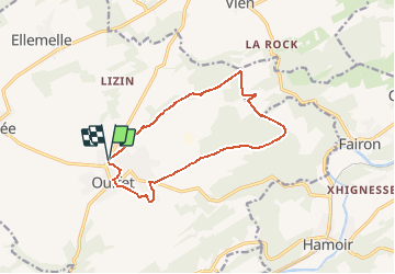
13,9 km | 18,2 km-effort
2h 56min
![](https://static1.geolcdn.com/siteimages/upload/files/16400158638029165_repeat_loop_refresh_sync_direction_icon.png)
Oui
![Randonnée Marche Hamoir - HAMOIR (Vallée du Neblon) - Photo](https://media.geolcdn.com/t/375/260/bd133f9f-5595-47e8-88c0-4d09e83d3ba8.jpg&format=jpg&maxdim=2)
![Marche Marche](https://static1.geolcdn.com/sitytour/trail-icons/101.png)
HAMOIR (Vallée du Neblon)
Marche
Moyen
(1)
Hamoir,
Wallonie,
Liège,
Belgique
![](/images/other/stat-length.png)
8,6 km | 11,4 km-effort
2h 28min
![](https://static1.geolcdn.com/siteimages/upload/files/16400158638029165_repeat_loop_refresh_sync_direction_icon.png)
Oui
![Randonnée A pied Anthisnes - AS03 Boucle de Tolumont - Photo](https://media.geolcdn.com/t/375/260/bb3be3cf-eddc-4622-8273-ff9944f2671c.jpg&format=jpg&maxdim=2)
![A pied A pied](https://static1.geolcdn.com/sitytour/trail-icons/100.png)
AS03 Boucle de Tolumont
A pied
Moyen
(1)
Anthisnes,
Wallonie,
Liège,
Belgique
![](/images/other/stat-length.png)
13,4 km | 17,6 km-effort
3h 20min
![](https://static1.geolcdn.com/siteimages/upload/files/16400158638029165_repeat_loop_refresh_sync_direction_icon.png)
Oui
![Randonnée Marche Ferrières - RL-GG-15_Sy_Barvaux - Photo](https://media.geolcdn.com/t/375/260/4cf6fb9a-77d5-4c51-bb72-4b6ca6a27202.jpg&format=jpg&maxdim=2)
![Marche Marche](https://static1.geolcdn.com/sitytour/trail-icons/101.png)
RL-GG-15_Sy_Barvaux
Marche
Très difficile
(1)
Ferrières,
Wallonie,
Liège,
Belgique
![](/images/other/stat-length.png)
18,9 km | 26 km-effort
5h 58min
![](https://static1.geolcdn.com/siteimages/upload/files/16400158638029165_repeat_loop_refresh_sync_direction_icon.png)
Non
![Randonnée Marche Anthisnes - Hody . drive d Anthisnes . carrière . Targnon . Hestreux . Fond de Sart . Hody - Photo](https://media.geolcdn.com/t/375/260/ac4de494-7be1-46d6-92d3-c5a298377ce3.jpg&format=jpg&maxdim=2)
![Marche Marche](https://static1.geolcdn.com/sitytour/trail-icons/101.png)
Hody . drive d Anthisnes . carrière . Targnon . Hestreux . Fond de Sart . Hody
Marche
Facile
(1)
Anthisnes,
Wallonie,
Liège,
Belgique
![](/images/other/stat-length.png)
11,5 km | 14,2 km-effort
3h 6min
![](https://static1.geolcdn.com/siteimages/upload/files/16400158638029165_repeat_loop_refresh_sync_direction_icon.png)
Oui
![Marche Marche](https://static1.geolcdn.com/sitytour/trail-icons/101.png)
![Randonnée Marche Ouffet - ouffet fermes ac + - Photo](https://media.geolcdn.com/t/375/260/fd6ab0a5-da2e-4ec4-9fa1-96c42c21280a.jpg&format=jpg&maxdim=2)
![Marche Marche](https://static1.geolcdn.com/sitytour/trail-icons/101.png)
ouffet fermes ac +
Marche
Moyen
(2)
Ouffet,
Wallonie,
Liège,
Belgique
![](/images/other/stat-length.png)
8,6 km | 10,7 km-effort
2h 41min
![](https://static1.geolcdn.com/siteimages/upload/files/16400158638029165_repeat_loop_refresh_sync_direction_icon.png)
Oui
![Randonnée Marche Hamoir - Hamoir adepstr - Photo](https://media.geolcdn.com/t/375/260/f7c6aedd-db0e-4e45-9994-a9f8bea87367.jpg&format=jpg&maxdim=2)
![Marche Marche](https://static1.geolcdn.com/sitytour/trail-icons/101.png)
Hamoir adepstr
Marche
Très difficile
(1)
Hamoir,
Wallonie,
Liège,
Belgique
![](/images/other/stat-length.png)
21 km | 26 km-effort
4h 23min
![](https://static1.geolcdn.com/siteimages/upload/files/16400158638029165_repeat_loop_refresh_sync_direction_icon.png)
Oui
![Randonnée Marche Anthisnes - départ du château de l'Avouerie d'Anthisnes - Photo](https://media.geolcdn.com/t/375/260/ext.jpg?maxdim=2&url=https%3A%2F%2Fservices.sitytrail.com%2FGeolivesWS%2FDownloadMedia.ashx%3FTrailID%3D688091%26Media%3D20170122160059.jpg)
![Marche Marche](https://static1.geolcdn.com/sitytour/trail-icons/101.png)
départ du château de l'Avouerie d'Anthisnes
Marche
Très facile
(1)
Anthisnes,
Wallonie,
Liège,
Belgique
![](/images/other/stat-length.png)
10,1 km | 12,4 km-effort
2h 48min
![](https://static1.geolcdn.com/siteimages/upload/files/16400158638029165_repeat_loop_refresh_sync_direction_icon.png)
Oui