![](/images/other/stat-length.png)
![Randonnée Marche Romilly-sur-Andelle - Romilly-sur-Andelle 2017-03-09 - GD - 10,8km - Photo](https://media.geolcdn.com/t/1900/400/ext.pjpeg?maxdim=2&url=https%3A%2F%2Fstatic1.geolcdn.com%2Fsiteimages%2Fupload%2Ffiles%2F1553511878bg_sport_marche.png)
Romilly-sur-Andelle 2017-03-09 - GD - 10,8km
philippe76
Utilisateur
![Longueur](/images/other/stat-length.png)
![Altitude max](https://static1.geolcdn.com/siteimages/upload/files/1508320355ic_sort_altitude_max_24dp.png)
![Dénivelé positif](https://static1.geolcdn.com/siteimages/upload/files/1508320355ic_sort_den_pos_24dp.png)
![Km-Effort](/images/other/stat-length.png)
![Altitude min](https://static1.geolcdn.com/siteimages/upload/files/1508320355ic_sort_altitude_min_24dp.png)
![Dénivelé négatif](https://static1.geolcdn.com/siteimages/upload/files/1508320355ic_sort_den_neg_24dp.png)
![Boucle](https://static1.geolcdn.com/siteimages/upload/files/16400158638029165_repeat_loop_refresh_sync_direction_icon.png)
![Marche](https://static1.geolcdn.com/sitytour/trail-icons/101.png)
2h57
Difficulté : Moyen
![Scannez ce code QR pour ouvrir la randonnée dans l'application SityTrail](https://capi.geolives.com/qq0zvz2zws4bq2lad0pu/sitytour/trails/709219/qr.png?size=200)
Application GPS de randonnée GRATUITE
À propos
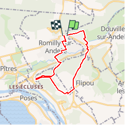
Randonnée Marche de 11 km à découvrir à Normandie, Eure, Romilly-sur-Andelle. Cette randonnée est proposée par philippe76.
Description
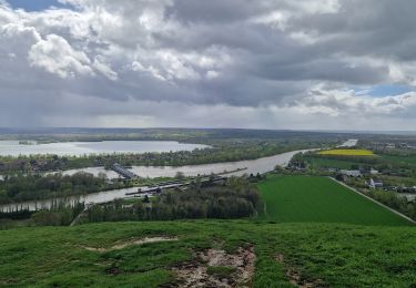
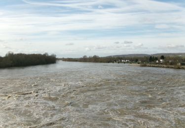
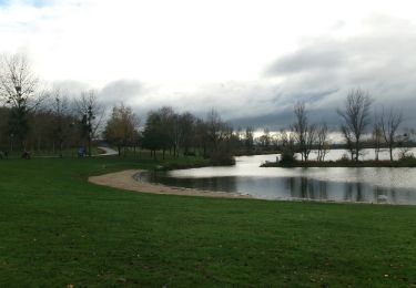
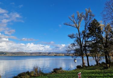
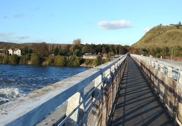
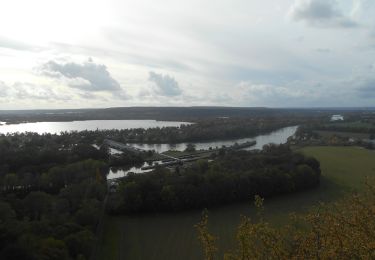
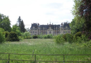
Départ parking du Collège rue de la Libération, puis chemin aux bœufs. Après le cimetière Chemin AD, et TD jusqu'à l'Andelle, puis Avenue du Chateau. AG Grande Rue, AD rue des hautes rives, et AG traverser la voie ferrée. AD chemin montant, AG suivre le GRP "le royaume de Pïtres". Sur le plateau AD (avant rte du Plessis, AD et AG en traversant la rte des 2 amants. AD, AD et passer près de la mare Ruchon, AG rte des 2 amants et faire un AR au Belvédère. Reprendre la rte des 2 amants, AG PT 146, AG vers pt 140, AG pt 62 sentier val aux lievres, Traverser Voie ferrée, AD sentier du rivage, TD, AG, AD puis rue Blingue, AG chemin, puis chmin planche du moulin Cabot, AD rue Planquette, AG chemin vers Collège.
Localisation
Commentaires
Randonnées à proximité
![Randonnée Marche Amfreville-sous-les-Monts - Côte des Deux amants (107) - Photo](https://media.geolcdn.com/t/375/260/ext.jpg?maxdim=2&url=https%3A%2F%2Fstatic1.geolcdn.com%2Fsiteimages%2Fupload%2Ffiles%2F1553511878bg_sport_marche.png)
![Marche Marche](https://static1.geolcdn.com/sitytour/trail-icons/101.png)
Marche
![](/images/other/stat-length.png)
![](https://static1.geolcdn.com/siteimages/upload/files/16400158638029165_repeat_loop_refresh_sync_direction_icon.png)
![Randonnée Marche Pont-Saint-Pierre - 27-03-Flipou Pont Saint Pierre 14km-486-478- - Photo](https://media.geolcdn.com/t/375/260/5f192092-f3eb-4914-a0dc-a7ccf7ccb6ff.jpg&format=jpg&maxdim=2)
![Marche Marche](https://static1.geolcdn.com/sitytour/trail-icons/101.png)
Marche
![](/images/other/stat-length.png)
![](https://static1.geolcdn.com/siteimages/upload/files/16400158638029165_repeat_loop_refresh_sync_direction_icon.png)
![Randonnée Marche Pont-Saint-Pierre - 20240409-Flipou - Photo](https://media.geolcdn.com/t/375/260/88d68366-9846-42f8-8298-7e7b63133a02.jpg&format=jpg&maxdim=2)
![Marche Marche](https://static1.geolcdn.com/sitytour/trail-icons/101.png)
Marche
![](/images/other/stat-length.png)
![](https://static1.geolcdn.com/siteimages/upload/files/16400158638029165_repeat_loop_refresh_sync_direction_icon.png)
![Marche Marche](https://static1.geolcdn.com/sitytour/trail-icons/101.png)
Marche
![](/images/other/stat-length.png)
![](https://static1.geolcdn.com/siteimages/upload/files/16400158638029165_repeat_loop_refresh_sync_direction_icon.png)
![Marche Marche](https://static1.geolcdn.com/sitytour/trail-icons/101.png)
Marche
![](/images/other/stat-length.png)
![](https://static1.geolcdn.com/siteimages/upload/files/16400158638029165_repeat_loop_refresh_sync_direction_icon.png)
![Randonnée Marche Amfreville-sous-les-Monts - 20231114-Poses - Photo](https://media.geolcdn.com/t/375/260/b2f08aa4-2a1d-49db-9d1b-23ac53c5301f.jpg&format=jpg&maxdim=2)
![Marche Marche](https://static1.geolcdn.com/sitytour/trail-icons/101.png)
Marche
![](/images/other/stat-length.png)
![](https://static1.geolcdn.com/siteimages/upload/files/16400158638029165_repeat_loop_refresh_sync_direction_icon.png)
![Randonnée Marche Poses - Poses le Val Pitan - Photo](https://media.geolcdn.com/t/375/260/4c42f14a-6884-4e67-8d15-a7596b1ce635.jpg&format=jpg&maxdim=2)
![Marche Marche](https://static1.geolcdn.com/sitytour/trail-icons/101.png)
Marche
![](/images/other/stat-length.png)
![](https://static1.geolcdn.com/siteimages/upload/files/16400158638029165_repeat_loop_refresh_sync_direction_icon.png)
![Marche Marche](https://static1.geolcdn.com/sitytour/trail-icons/101.png)
Marche
![](/images/other/stat-length.png)
![](https://static1.geolcdn.com/siteimages/upload/files/16400158638029165_repeat_loop_refresh_sync_direction_icon.png)