![](/images/other/stat-length.png)
![Randonnée Marche Saint-Julien-en-Quint - Du Quint à Gagère par la porte d'urle - Photo](https://media.geolcdn.com/t/1900/400/ext.pjpeg?maxdim=2&url=https%3A%2F%2Fstatic1.geolcdn.com%2Fsiteimages%2Fupload%2Ffiles%2F1553511878bg_sport_marche.png)
Du Quint à Gagère par la porte d'urle
fabal
Utilisateur
![Longueur](/images/other/stat-length.png)
Longueur
18,3 km
![Altitude max](https://static1.geolcdn.com/siteimages/upload/files/1508320355ic_sort_altitude_max_24dp.png)
Altitude max
1643 m
![Dénivelé positif](https://static1.geolcdn.com/siteimages/upload/files/1508320355ic_sort_den_pos_24dp.png)
Dénivelé positif
1202 m
![Km-Effort](/images/other/stat-length.png)
Km-Effort
34 km
![Altitude min](https://static1.geolcdn.com/siteimages/upload/files/1508320355ic_sort_altitude_min_24dp.png)
Altitude min
590 m
![Dénivelé négatif](https://static1.geolcdn.com/siteimages/upload/files/1508320355ic_sort_den_neg_24dp.png)
Dénivelé négatif
1205 m
![Boucle](https://static1.geolcdn.com/siteimages/upload/files/16400158638029165_repeat_loop_refresh_sync_direction_icon.png)
Boucle
Oui
Date de création :
2017-03-03 00:00:00.0
Dernière modification :
2017-03-03 00:00:00.0
![Marche](https://static1.geolcdn.com/sitytour/trail-icons/101.png)
7h14
Difficulté : Difficile
![Scannez ce code QR pour ouvrir la randonnée dans l'application SityTrail](https://capi.geolives.com/qq0zvz2zws4bq2lad0pu/sitytour/trails/708039/qr.png?size=200)
Application GPS de randonnée GRATUITE
À propos
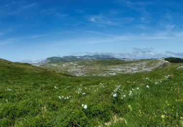
Randonnée Marche de 18,3 km à découvrir à Auvergne-Rhône-Alpes, Drôme, Saint-Julien-en-Quint. Cette randonnée est proposée par fabal.
Description
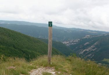
Départ des Faures en direction de la porte d'urle.
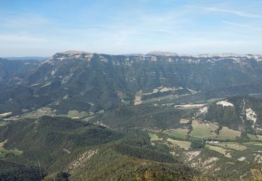
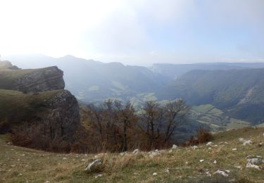
On suit la falaise jusqu'au Puy de la Gagère.
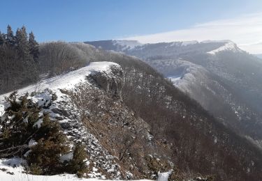
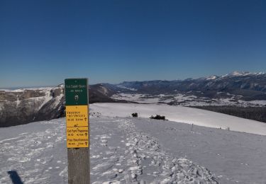
Descente jusqu'au col de Payanne puis vers le hameau des Bonnets
Localisation
Pays :
France
Région :
Auvergne-Rhône-Alpes
Département/Province :
Drôme
Commune :
Saint-Julien-en-Quint
Localité :
Unknown
Départ:(Dec)
Départ:(UTM)
681802 ; 4969238 (31T) N.
Commentaires
Randonnées à proximité
![Randonnée Marche Omblèze - Plateau d'Ambel 15km. - Photo](https://media.geolcdn.com/t/375/260/07e91571-7633-48aa-a91e-19fa46a2d0cc.jpg&format=jpg&maxdim=2)
![Marche Marche](https://static1.geolcdn.com/sitytour/trail-icons/101.png)
Plateau d'Ambel 15km.
Marche
Très difficile
(1)
Omblèze,
Auvergne-Rhône-Alpes,
Drôme,
France
![](/images/other/stat-length.png)
14,9 km | 22 km-effort
4h 56min
![](https://static1.geolcdn.com/siteimages/upload/files/16400158638029165_repeat_loop_refresh_sync_direction_icon.png)
Oui
![Randonnée Marche Saint-Julien-en-Quint - Bec Pointu - Les Glovins - St-Julien-en-Quint - Photo](https://media.geolcdn.com/t/375/260/878efec7-ca71-44c9-bf9b-82849e6087b9.jpg&format=jpg&maxdim=2)
![Marche Marche](https://static1.geolcdn.com/sitytour/trail-icons/101.png)
Bec Pointu - Les Glovins - St-Julien-en-Quint
Marche
Difficile
Saint-Julien-en-Quint,
Auvergne-Rhône-Alpes,
Drôme,
France
![](/images/other/stat-length.png)
11,5 km | 22 km-effort
5h 40min
![](https://static1.geolcdn.com/siteimages/upload/files/16400158638029165_repeat_loop_refresh_sync_direction_icon.png)
Oui
![Randonnée Marche Saint-Julien-en-Quint - pas de bouillanain st julien en Quint - Photo](https://media.geolcdn.com/t/375/260/e24dab84-0d8d-4e1a-9d55-adf9e6345b23.jpg&format=jpg&maxdim=2)
![Marche Marche](https://static1.geolcdn.com/sitytour/trail-icons/101.png)
pas de bouillanain st julien en Quint
Marche
Difficile
Saint-Julien-en-Quint,
Auvergne-Rhône-Alpes,
Drôme,
France
![](/images/other/stat-length.png)
17 km | 29 km-effort
5h 6min
![](https://static1.geolcdn.com/siteimages/upload/files/16400158638029165_repeat_loop_refresh_sync_direction_icon.png)
Oui
![Randonnée Marche Vassieux-en-Vercors - But St Genis - Photo](https://media.geolcdn.com/t/375/260/7dc5994c-58ff-4977-a518-836cfc09796c.jpg&format=jpg&maxdim=2)
![Marche Marche](https://static1.geolcdn.com/sitytour/trail-icons/101.png)
But St Genis
Marche
Facile
Vassieux-en-Vercors,
Auvergne-Rhône-Alpes,
Drôme,
France
![](/images/other/stat-length.png)
12,8 km | 20 km-effort
3h 52min
![](https://static1.geolcdn.com/siteimages/upload/files/16400158638029165_repeat_loop_refresh_sync_direction_icon.png)
Oui
![Randonnée Marche Vassieux-en-Vercors - Forêt communale de Dié - Photo](https://media.geolcdn.com/t/375/260/81a065f0-a659-4198-8cfc-a4d3daa2067f.jpg&format=jpg&maxdim=2)
![Marche Marche](https://static1.geolcdn.com/sitytour/trail-icons/101.png)
Forêt communale de Dié
Marche
Difficile
Vassieux-en-Vercors,
Auvergne-Rhône-Alpes,
Drôme,
France
![](/images/other/stat-length.png)
10,7 km | 14,8 km-effort
3h 21min
![](https://static1.geolcdn.com/siteimages/upload/files/16400158638029165_repeat_loop_refresh_sync_direction_icon.png)
Oui
![Randonnée Marche Saint-Julien-en-Quint - Puy de la Gagere, Porte d’Urle - Photo](https://media.geolcdn.com/t/375/260/e2307571-55f1-4e4e-ad84-7190356d726e.jpg&format=jpg&maxdim=2)
![Marche Marche](https://static1.geolcdn.com/sitytour/trail-icons/101.png)
Puy de la Gagere, Porte d’Urle
Marche
Difficile
Saint-Julien-en-Quint,
Auvergne-Rhône-Alpes,
Drôme,
France
![](/images/other/stat-length.png)
19,3 km | 34 km-effort
6h 45min
![](https://static1.geolcdn.com/siteimages/upload/files/16400158638029165_repeat_loop_refresh_sync_direction_icon.png)
Oui
![Randonnée Marche Omblèze - Plateau d'Ambel 15km - Photo](https://media.geolcdn.com/t/375/260/0ff22542-c45b-4fc6-868c-010c97d00b52.jpg&format=jpg&maxdim=2)
![Marche Marche](https://static1.geolcdn.com/sitytour/trail-icons/101.png)
Plateau d'Ambel 15km
Marche
Moyen
Omblèze,
Auvergne-Rhône-Alpes,
Drôme,
France
![](/images/other/stat-length.png)
14,8 km | 22 km-effort
4h 20min
![](https://static1.geolcdn.com/siteimages/upload/files/16400158638029165_repeat_loop_refresh_sync_direction_icon.png)
Oui
![Randonnée Marche Bouvante - Fond d'Urle Chaud Clapier - Photo](https://media.geolcdn.com/t/375/260/4a8e0c5c-95fa-438b-87df-304eace0b559.jpg&format=jpg&maxdim=2)
![Marche Marche](https://static1.geolcdn.com/sitytour/trail-icons/101.png)
Fond d'Urle Chaud Clapier
Marche
Moyen
Bouvante,
Auvergne-Rhône-Alpes,
Drôme,
France
![](/images/other/stat-length.png)
12,7 km | 19,6 km-effort
4h 10min
![](https://static1.geolcdn.com/siteimages/upload/files/16400158638029165_repeat_loop_refresh_sync_direction_icon.png)
Oui
![Randonnée Marche Vassieux-en-Vercors - 26 but st génie raquettes - Photo](https://media.geolcdn.com/t/375/260/c60ab361-7569-4d55-9877-eaa92e5ab9b3.jpg&format=jpg&maxdim=2)
![Marche Marche](https://static1.geolcdn.com/sitytour/trail-icons/101.png)
26 but st génie raquettes
Marche
Moyen
Vassieux-en-Vercors,
Auvergne-Rhône-Alpes,
Drôme,
France
![](/images/other/stat-length.png)
10,6 km | 16,8 km-effort
5h 26min
![](https://static1.geolcdn.com/siteimages/upload/files/16400158638029165_repeat_loop_refresh_sync_direction_icon.png)
Non