![](/images/other/stat-length.png)
![Randonnée Marche Vecoux - Vecoux -Dommartin - Photo](https://media.geolcdn.com/t/1900/400/ext.pjpeg?maxdim=2&url=https%3A%2F%2Fstatic1.geolcdn.com%2Fsiteimages%2Fupload%2Ffiles%2F1553511878bg_sport_marche.png)
Vecoux -Dommartin
jeanclaude12
Utilisateur
![Longueur](/images/other/stat-length.png)
Longueur
9,4 km
![Altitude max](https://static1.geolcdn.com/siteimages/upload/files/1508320355ic_sort_altitude_max_24dp.png)
Altitude max
708 m
![Dénivelé positif](https://static1.geolcdn.com/siteimages/upload/files/1508320355ic_sort_den_pos_24dp.png)
Dénivelé positif
340 m
![Km-Effort](/images/other/stat-length.png)
Km-Effort
14,1 km
![Altitude min](https://static1.geolcdn.com/siteimages/upload/files/1508320355ic_sort_altitude_min_24dp.png)
Altitude min
403 m
![Dénivelé négatif](https://static1.geolcdn.com/siteimages/upload/files/1508320355ic_sort_den_neg_24dp.png)
Dénivelé négatif
386 m
![Boucle](https://static1.geolcdn.com/siteimages/upload/files/16400158638029165_repeat_loop_refresh_sync_direction_icon.png)
Boucle
Non
Date de création :
2017-02-14 00:00:00.0
Dernière modification :
2017-02-14 00:00:00.0
![Marche](https://static1.geolcdn.com/sitytour/trail-icons/101.png)
2h35
Difficulté : Moyen
![Scannez ce code QR pour ouvrir la randonnée dans l'application SityTrail](https://capi.geolives.com/qq0zvz2zws4bq2lad0pu/sitytour/trails/698376/qr.png?size=200)
Application GPS de randonnée GRATUITE
À propos
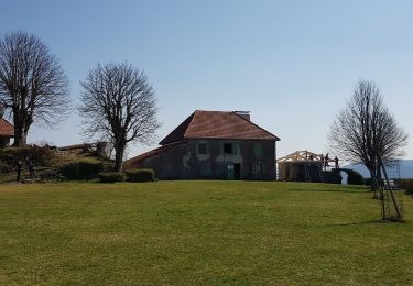
Randonnée Marche de 9,4 km à découvrir à Grand Est, Vosges, Vecoux. Cette randonnée est proposée par jeanclaude12.
Description
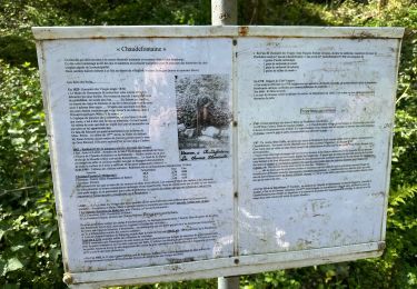
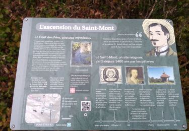
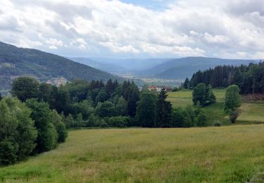
Du parking de Semoflex, montée vers la Vierge de Mai, Grande Goutte, la Roche des Hats, l'ancien Etang Sauveget, et retour par le Pré de la Grange (ou Grande mange) et le très agréable Sentier du Tulipier.
Localisation
Pays :
France
Région :
Grand Est
Département/Province :
Vosges
Commune :
Vecoux
Localité :
Unknown
Départ:(Dec)
Départ:(UTM)
323942 ; 5317105 (32T) N.
Commentaires
Randonnées à proximité
![Randonnée Marche Saint-Amé - carrière de Saint Amé - Photo](https://media.geolcdn.com/t/375/260/ext.jpg?maxdim=2&url=https%3A%2F%2Fservices.sitytrail.com%2FGeolivesWS%2FDownloadMedia.ashx%3FTrailID%3D430825%26Media%3D20150607155818.jpg)
![Marche Marche](https://static1.geolcdn.com/sitytour/trail-icons/101.png)
carrière de Saint Amé
Marche
Moyen
(1)
Saint-Amé,
Grand Est,
Vosges,
France
![](/images/other/stat-length.png)
8,6 km | 12,6 km-effort
2h 13min
![](https://static1.geolcdn.com/siteimages/upload/files/16400158638029165_repeat_loop_refresh_sync_direction_icon.png)
Oui
![Randonnée Marche Le Syndicat - Balcon du Solem - Photo](https://media.geolcdn.com/t/375/260/ext.jpg?maxdim=2&url=https%3A%2F%2Fservices.sitytrail.com%2FGeolivesWS%2FDownloadMedia.ashx%3FTrailID%3D109882%26Media%3D4887_1.jpg)
![Marche Marche](https://static1.geolcdn.com/sitytour/trail-icons/101.png)
Balcon du Solem
Marche
Moyen
(1)
Le Syndicat,
Grand Est,
Vosges,
France
![](/images/other/stat-length.png)
4,3 km | 7,4 km-effort
2h 0min
![](https://static1.geolcdn.com/siteimages/upload/files/16400158638029165_repeat_loop_refresh_sync_direction_icon.png)
Oui
![Randonnée Marche Remiremont - Remiremont (Girmont-Val-d'Ajol) 22 880m +729m - Photo](https://media.geolcdn.com/t/375/260/ext.jpg?maxdim=2&url=https%3A%2F%2Fstatic1.geolcdn.com%2Fsiteimages%2Fupload%2Ffiles%2F1553511878bg_sport_marche.png)
![Marche Marche](https://static1.geolcdn.com/sitytour/trail-icons/101.png)
Remiremont (Girmont-Val-d'Ajol) 22 880m +729m
Marche
Très difficile
(1)
Remiremont,
Grand Est,
Vosges,
France
![](/images/other/stat-length.png)
23 km | 33 km-effort
7h 24min
![](https://static1.geolcdn.com/siteimages/upload/files/16400158638029165_repeat_loop_refresh_sync_direction_icon.png)
Oui
![Randonnée Marche Vecoux - Chaudefontaine -grand lac- Chaudefontaine - Photo](https://media.geolcdn.com/t/375/260/e2d224f0-cc42-45e2-aa09-2f3731046682.jpg&format=jpg&maxdim=2)
![Marche Marche](https://static1.geolcdn.com/sitytour/trail-icons/101.png)
Chaudefontaine -grand lac- Chaudefontaine
Marche
Difficile
Vecoux,
Grand Est,
Vosges,
France
![](/images/other/stat-length.png)
8,6 km | 13,4 km-effort
3h 2min
![](https://static1.geolcdn.com/siteimages/upload/files/16400158638029165_repeat_loop_refresh_sync_direction_icon.png)
Oui
![Randonnée Marche Saint-Étienne-lès-Remiremont - rando chanoinesses 2024 - Photo](https://media.geolcdn.com/t/375/260/1f28ad57-0bac-42c5-a239-cee2db707493.jpg&format=jpg&maxdim=2)
![Marche Marche](https://static1.geolcdn.com/sitytour/trail-icons/101.png)
rando chanoinesses 2024
Marche
Moyen
Saint-Étienne-lès-Remiremont,
Grand Est,
Vosges,
France
![](/images/other/stat-length.png)
12,5 km | 18 km-effort
2h 32min
![](https://static1.geolcdn.com/siteimages/upload/files/16400158638029165_repeat_loop_refresh_sync_direction_icon.png)
Non
![Randonnée Marche Girmont-Val-d'Ajol - GIRMONT VAL D'AJOL - Photo](https://media.geolcdn.com/t/375/260/ext.jpg?maxdim=2&url=https%3A%2F%2Fstatic1.geolcdn.com%2Fsiteimages%2Fupload%2Ffiles%2F1553511878bg_sport_marche.png)
![Marche Marche](https://static1.geolcdn.com/sitytour/trail-icons/101.png)
GIRMONT VAL D'AJOL
Marche
Difficile
(1)
Girmont-Val-d'Ajol,
Grand Est,
Vosges,
France
![](/images/other/stat-length.png)
9,3 km | 12,9 km-effort
2h 55min
![](https://static1.geolcdn.com/siteimages/upload/files/16400158638029165_repeat_loop_refresh_sync_direction_icon.png)
Oui
![Randonnée Marche Vecoux - Chalet avuxon / La Vrille / Col de Xiard variante - Photo](https://media.geolcdn.com/t/375/260/ext.jpg?maxdim=2&url=https%3A%2F%2Fstatic1.geolcdn.com%2Fsiteimages%2Fupload%2Ffiles%2F1553511878bg_sport_marche.png)
![Marche Marche](https://static1.geolcdn.com/sitytour/trail-icons/101.png)
Chalet avuxon / La Vrille / Col de Xiard variante
Marche
Difficile
(1)
Vecoux,
Grand Est,
Vosges,
France
![](/images/other/stat-length.png)
12,3 km | 19,1 km-effort
4h 20min
![](https://static1.geolcdn.com/siteimages/upload/files/16400158638029165_repeat_loop_refresh_sync_direction_icon.png)
Oui
![Randonnée Randonnée équestre Dommartin-lès-Remiremont - 2022-06-06 Rando CVA Dommartin Les Remiremont Le Tholy - Photo](https://media.geolcdn.com/t/375/260/b2ad3e4f-4401-450f-898b-3ec212cd2124.jpg&format=jpg&maxdim=2)
![Randonnée équestre Randonnée équestre](https://static1.geolcdn.com/sitytour/trail-icons/301.png)
2022-06-06 Rando CVA Dommartin Les Remiremont Le Tholy
Randonnée équestre
Moyen
Dommartin-lès-Remiremont,
Grand Est,
Vosges,
France
![](/images/other/stat-length.png)
22 km | 31 km-effort
3h 56min
![](https://static1.geolcdn.com/siteimages/upload/files/16400158638029165_repeat_loop_refresh_sync_direction_icon.png)
Non
![Randonnée Marche Saint-Étienne-lès-Remiremont - 20220324_rando_ST-ETIENNE-LES-REMIREMONT_N_Sur_les_pas_de_St_Romary - Photo](https://media.geolcdn.com/t/375/260/264a1181-fa8b-4d31-b067-498da8b75069.jpg&format=jpg&maxdim=2)
![Marche Marche](https://static1.geolcdn.com/sitytour/trail-icons/101.png)
20220324_rando_ST-ETIENNE-LES-REMIREMONT_N_Sur_les_pas_de_St_Romary
Marche
Très difficile
Saint-Étienne-lès-Remiremont,
Grand Est,
Vosges,
France
![](/images/other/stat-length.png)
15,8 km | 25 km-effort
5h 36min
![](https://static1.geolcdn.com/siteimages/upload/files/16400158638029165_repeat_loop_refresh_sync_direction_icon.png)
Oui