![](/images/other/stat-length.png)
![Randonnée Marche Le Tampon - Boucle trous blancs - Photo](https://media.geolcdn.com/t/1900/400/ext.pjpeg?maxdim=2&url=https%3A%2F%2Fstatic1.geolcdn.com%2Fsiteimages%2Fupload%2Ffiles%2F1553511878bg_sport_marche.png)
Boucle trous blancs
Fdum
Utilisateur
![Longueur](/images/other/stat-length.png)
Longueur
3,9 km
![Altitude max](https://static1.geolcdn.com/siteimages/upload/files/1508320355ic_sort_altitude_max_24dp.png)
Altitude max
2021 m
![Dénivelé positif](https://static1.geolcdn.com/siteimages/upload/files/1508320355ic_sort_den_pos_24dp.png)
Dénivelé positif
182 m
![Km-Effort](/images/other/stat-length.png)
Km-Effort
6,3 km
![Altitude min](https://static1.geolcdn.com/siteimages/upload/files/1508320355ic_sort_altitude_min_24dp.png)
Altitude min
1836 m
![Dénivelé négatif](https://static1.geolcdn.com/siteimages/upload/files/1508320355ic_sort_den_neg_24dp.png)
Dénivelé négatif
179 m
![Boucle](https://static1.geolcdn.com/siteimages/upload/files/16400158638029165_repeat_loop_refresh_sync_direction_icon.png)
Boucle
Oui
Date de création :
2017-01-22 00:00:00.0
Dernière modification :
2017-01-22 00:00:00.0
![Marche](https://static1.geolcdn.com/sitytour/trail-icons/101.png)
1h15
Difficulté : Très facile
![Scannez ce code QR pour ouvrir la randonnée dans l'application SityTrail](https://capi.geolives.com/qq0zvz2zws4bq2lad0pu/sitytour/trails/687742/qr.png?size=200)
Application GPS de randonnée GRATUITE
À propos
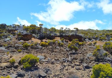
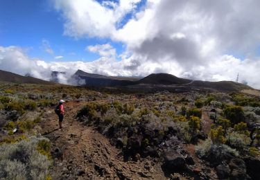
Randonnée Marche de 3,9 km à découvrir à La Réunion, Inconnu, Le Tampon. Cette randonnée est proposée par Fdum.
Description
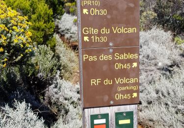
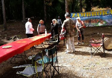
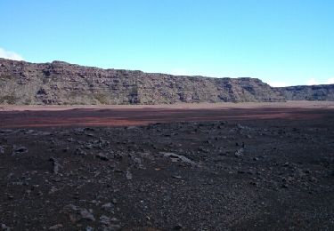
Très facile. Vous pouvez vous garer un peu plus haut sur le chemin. Il y a beaucoup de tables pour le pique nique. De même vous pouvez descendre dans le deuxième trou, en direction de piton sec... A vos GPS
Localisation
Pays :
France
Région :
La Réunion
Département/Province :
Inconnu
Commune :
Le Tampon
Localité :
Unknown
Départ:(Dec)
Départ:(UTM)
355298 ; 7654776 (40K) S.
Commentaires
Randonnées à proximité
![Randonnée Marche Saint-Joseph - Morne Langevin - Photo](https://media.geolcdn.com/t/375/260/4a48cc84-a345-4e59-a26e-9ebfc18443b6.jpg&format=jpg&maxdim=2)
![Marche Marche](https://static1.geolcdn.com/sitytour/trail-icons/101.png)
Morne Langevin
Marche
Facile
Saint-Joseph,
La Réunion,
Inconnu,
France
![](/images/other/stat-length.png)
10,7 km | 14,4 km-effort
2h 43min
![](https://static1.geolcdn.com/siteimages/upload/files/16400158638029165_repeat_loop_refresh_sync_direction_icon.png)
Oui
![Randonnée Marche Le Tampon - Piton de l'eau par le Rempart de la Rivière de l'Est - Photo](https://media.geolcdn.com/t/375/260/ccd7d241-7acf-406b-b558-3fd236979d1f.jpg&format=jpg&maxdim=2)
![Marche Marche](https://static1.geolcdn.com/sitytour/trail-icons/101.png)
Piton de l'eau par le Rempart de la Rivière de l'Est
Marche
Moyen
Le Tampon,
La Réunion,
Inconnu,
France
![](/images/other/stat-length.png)
18,4 km | 27 km-effort
5h 0min
![](https://static1.geolcdn.com/siteimages/upload/files/16400158638029165_repeat_loop_refresh_sync_direction_icon.png)
Oui
![Randonnée A pied Le Tampon - 3 pitons à Bourg Murat - Photo](https://media.geolcdn.com/t/375/260/970bad91-7bf9-4096-b52f-d8b7555be2f2.jpg&format=jpg&maxdim=2)
![A pied A pied](https://static1.geolcdn.com/sitytour/trail-icons/100.png)
3 pitons à Bourg Murat
A pied
Moyen
Le Tampon,
La Réunion,
Inconnu,
France
![](/images/other/stat-length.png)
12,4 km | 16,4 km-effort
Inconnu
![](https://static1.geolcdn.com/siteimages/upload/files/16400158638029165_repeat_loop_refresh_sync_direction_icon.png)
Oui
![Randonnée Marche Le Tampon - bourg murat la fournaise - Photo](https://media.geolcdn.com/t/375/260/90df9966-627c-4173-ae45-ca4957fd7ec0.jpg&format=jpg&maxdim=2)
![Marche Marche](https://static1.geolcdn.com/sitytour/trail-icons/101.png)
bourg murat la fournaise
Marche
Difficile
Le Tampon,
La Réunion,
Inconnu,
France
![](/images/other/stat-length.png)
19,1 km | 29 km-effort
7h 38min
![](https://static1.geolcdn.com/siteimages/upload/files/16400158638029165_repeat_loop_refresh_sync_direction_icon.png)
Non
![Randonnée Marche Saint-Joseph - Boucle autour de la plaine des sables - Photo](https://media.geolcdn.com/t/375/260/c4eaba1a-2561-47f6-8299-57d93e516a4a.jpg&format=jpg&maxdim=2)
![Marche Marche](https://static1.geolcdn.com/sitytour/trail-icons/101.png)
Boucle autour de la plaine des sables
Marche
Difficile
Saint-Joseph,
La Réunion,
Inconnu,
France
![](/images/other/stat-length.png)
16,2 km | 21 km-effort
4h 49min
![](https://static1.geolcdn.com/siteimages/upload/files/16400158638029165_repeat_loop_refresh_sync_direction_icon.png)
Oui
![Randonnée Marche Saint-Joseph - La Réunion - Retour - Ravine Citron Galet par le nez de Boeufs - Photo](https://media.geolcdn.com/t/375/260/ext.jpg?maxdim=2&url=https%3A%2F%2Fservices.sitytrail.com%2FGeolivesWS%2FDownloadMedia.ashx%3FTrailID%3D636153%26Media%3Dfix__20160925140435.jpg)
![Marche Marche](https://static1.geolcdn.com/sitytour/trail-icons/101.png)
La Réunion - Retour - Ravine Citron Galet par le nez de Boeufs
Marche
Moyen
Saint-Joseph,
La Réunion,
Inconnu,
France
![](/images/other/stat-length.png)
8,4 km | 24 km-effort
2h 9min
![](https://static1.geolcdn.com/siteimages/upload/files/16400158638029165_repeat_loop_refresh_sync_direction_icon.png)
Oui
![Randonnée Marche Le Tampon - Murat nez de bœuf - Photo](https://media.geolcdn.com/t/375/260/ext.jpg?maxdim=2&url=https%3A%2F%2Fstatic1.geolcdn.com%2Fsiteimages%2Fupload%2Ffiles%2F1553511878bg_sport_marche.png)
![Marche Marche](https://static1.geolcdn.com/sitytour/trail-icons/101.png)
Murat nez de bœuf
Marche
Très facile
(1)
Le Tampon,
La Réunion,
Inconnu,
France
![](/images/other/stat-length.png)
15,9 km | 23 km-effort
5h 23min
![](https://static1.geolcdn.com/siteimages/upload/files/16400158638029165_repeat_loop_refresh_sync_direction_icon.png)
Oui
![Randonnée Marche Le Tampon - Trous Blancs de Piton Sec - Photo](https://media.geolcdn.com/t/375/260/ext.jpg?maxdim=2&url=https%3A%2F%2Fservices.sitytrail.com%2FGeolivesWS%2FDownloadMedia.ashx%3FTrailID%3D452656%26Media%3Dfix__20150730105930.jpg)
![Marche Marche](https://static1.geolcdn.com/sitytour/trail-icons/101.png)
Trous Blancs de Piton Sec
Marche
Facile
(1)
Le Tampon,
La Réunion,
Inconnu,
France
![](/images/other/stat-length.png)
3,9 km | 6,1 km-effort
3h 4min
![](https://static1.geolcdn.com/siteimages/upload/files/16400158638029165_repeat_loop_refresh_sync_direction_icon.png)
Oui
![Randonnée Marche Saint-Joseph - La Réunion - Boucle de la Plaine des sables par l'Oratoire Sainte-Thérèse - Photo](https://media.geolcdn.com/t/375/260/ext.jpg?maxdim=2&url=https%3A%2F%2Fservices.sitytrail.com%2FGeolivesWS%2FDownloadMedia.ashx%3FTrailID%3D403539%26Media%3Dfix__20150404122807.jpg)
![Marche Marche](https://static1.geolcdn.com/sitytour/trail-icons/101.png)
La Réunion - Boucle de la Plaine des sables par l'Oratoire Sainte-Thérèse
Marche
Moyen
Saint-Joseph,
La Réunion,
Inconnu,
France
![](/images/other/stat-length.png)
15,8 km | 21 km-effort
5h 40min
![](https://static1.geolcdn.com/siteimages/upload/files/16400158638029165_repeat_loop_refresh_sync_direction_icon.png)
Oui