Randonnée Marche Loos-en-Gohelle - Terril 62 Loos en Gohelle - Photo
 taz5962
taz5962

Utilisateur

© OpenStreetMap contributors
Longueur
Longueur
6,1 km
Altitude max
Altitude max
165 m
Dénivelé positif
Dénivelé positif
158 m
Km-Effort
Km-Effort  
8,2 km
Altitude min
Altitude min
65 m
Dénivelé négatif
Dénivelé négatif
160 m
Boucle
Boucle
Oui
Date de création :
2017-11-30 00:00:00.0
Dernière modification :
2017-11-30 00:00:00.0

(0 Avis)

Marche
Marche
1h43
Difficulté : Moyen

Scannez ce code QR pour ouvrir la randonnée dans l'application SityTrail

Application GPS de randonnée GRATUITE

Logo SityTrail SityTrail

IGN / Instituts géographiques

Télécharger SityTrail sur l'App Store Télécharger SityTrail sur Google Play

Logo SityTrail SityTrail World

Le monde est à vous

Télécharger SityTrail sur l'App Store Télécharger SityTrail sur Google Play Télécharger SityTrail sur Huawei AppGallery

À propos

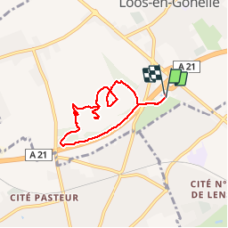
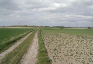
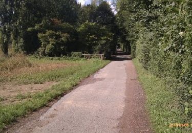
Randonnée Marche de 6,1 km à découvrir à Hauts-de-France, Pas-de-Calais, Loos-en-Gohelle. Cette randonnée est proposée par taz5962.

Description

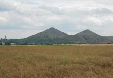
une balade sur les terrils du pas de calais

Profil altimétrique

Localisation

Pays :
France
Région :
Hauts-de-France
Département/Province :
Pas-de-Calais
Commune :
Loos-en-Gohelle
Localité :
Unknown
Départ:(Dec)
Départ:(UTM)
485217 ; 5588220 (31U) N.

Randonnées à proximité

Randonnée Marche Liévin - 50 km Lievin en nocturne - Photo
Marche
tracegps

Marche

Très difficile
(1)
Liévin, Hauts-de-France, Pas-de-Calais, France
52 km | 61 km-effort
9h 0min
Oui
Randonnée Marche Lens - randonnée  - Photo
Marche
sandrine brisset

Marche

Difficile
Lens, Hauts-de-France, Pas-de-Calais, France
10,5 km | 13,4 km-effort
3h 41min
Oui
Randonnée Marche Angres - randonnée pinchonvalles - Photo
Marche
Chene62

Marche

Très difficile
Angres, Hauts-de-France, Pas-de-Calais, France
27 km | 0 m-effort
3h 24min
Non
Randonnée Autre activité Liévin - boucle Liévin - Photo
Autre activité
crijack

Autre activité

Très facile
Liévin, Hauts-de-France, Pas-de-Calais, France
11 km | 12,3 km-effort
2h 2min
Oui
Randonnée Autre activité Liévin - boucle Liévin - Photo
Autre activité
crijack

Autre activité

Très facile
Liévin, Hauts-de-France, Pas-de-Calais, France
11 km | 12,3 km-effort
2h 2min
Oui
Randonnée Marche Vermelles - Autour de Vermellles - Photo
Marche
tracegps

Marche

Difficile
(1)
Vermelles, Hauts-de-France, Pas-de-Calais, France
15,8 km | 16,6 km-effort
4h 0min
Oui
Randonnée Marche Noyelles-lès-Vermelles - La voie ferrée - Noyelles-lès-Vermelles - Photo
Marche
tracegps

Marche

Difficile
Noyelles-lès-Vermelles, Hauts-de-France, Pas-de-Calais, France
13,7 km | 14,6 km-effort
3h 25min
Oui
Randonnée V.T.T. Angres - La randonnée VTT du Père Noël - Angres - Photo
V.T.T.
tracegps

V.T.T.

Difficile
(1)
Angres, Hauts-de-France, Pas-de-Calais, France
35 km | 42 km-effort
3h 0min
Oui
Randonnée Marche Aix-Noulette - Randonnée autour d' Aix Noulette - Photo
Marche
tracegps

Marche

Moyen
Aix-Noulette, Hauts-de-France, Pas-de-Calais, France
8,1 km | 10,1 km-effort
1h 40min
Oui


Fermer
Mes abonnements