![](/images/other/stat-length.png)
![Randonnée Autre activité Domfront en Poiraie - Basse Normandie - Ligne 00F - Alençon - Domfront Partie 2 - Photo](https://media.geolcdn.com/t/1900/400/ext.pjpeg?maxdim=2&url=https%3A%2F%2Fstatic1.geolcdn.com%2Fsiteimages%2Fupload%2Ffiles%2F1545311037marcheuse_200dpi.jpg)
Basse Normandie - Ligne 00F - Alençon - Domfront Partie 2
mich54
Utilisateur
![Longueur](/images/other/stat-length.png)
Longueur
3,1 km
![Altitude max](https://static1.geolcdn.com/siteimages/upload/files/1508320355ic_sort_altitude_max_24dp.png)
Altitude max
150 m
![Dénivelé positif](https://static1.geolcdn.com/siteimages/upload/files/1508320355ic_sort_den_pos_24dp.png)
Dénivelé positif
15 m
![Km-Effort](/images/other/stat-length.png)
Km-Effort
3,3 km
![Altitude min](https://static1.geolcdn.com/siteimages/upload/files/1508320355ic_sort_altitude_min_24dp.png)
Altitude min
123 m
![Dénivelé négatif](https://static1.geolcdn.com/siteimages/upload/files/1508320355ic_sort_den_neg_24dp.png)
Dénivelé négatif
26 m
![Boucle](https://static1.geolcdn.com/siteimages/upload/files/16400158638029165_repeat_loop_refresh_sync_direction_icon.png)
Boucle
Non
Date de création :
2017-01-18 00:00:00.0
Dernière modification :
2017-01-18 00:00:00.0
![Autre activité](https://static1.geolcdn.com/sitytour/trail-icons/900.png)
5m
Difficulté : Inconnu
![Scannez ce code QR pour ouvrir la randonnée dans l'application SityTrail](https://capi.geolives.com/qq0zvz2zws4bq2lad0pu/sitytour/trails/685821/qr.png?size=200)
Application GPS de randonnée GRATUITE
À propos
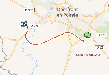
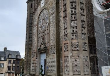
Randonnée Autre activité de 3,1 km à découvrir à Normandie, Orne, Domfront en Poiraie. Cette randonnée est proposée par mich54.
Description
Partie 2 de Saint-Front à Domfront (la section entre Saint-Front et Beaulandais est trop incertaine pour être tracée).
Localisation
Pays :
France
Région :
Normandie
Département/Province :
Orne
Commune :
Domfront en Poiraie
Localité :
Domfront
Départ:(Dec)
Départ:(UTM)
674287 ; 5383640 (30U) N.
Commentaires
Randonnées à proximité
![Randonnée Marche Domfront en Poiraie - La Chapelle du Cérisier - Domfront - Photo](https://media.geolcdn.com/t/375/260/ext.jpg?maxdim=2&url=https%3A%2F%2Fservices.sitytrail.com%2FGeolivesWS%2FDownloadMedia.ashx%3FTrailID%3D111660%26Media%3D7898_1.jpg)
![Marche Marche](https://static1.geolcdn.com/sitytour/trail-icons/101.png)
La Chapelle du Cérisier - Domfront
Marche
Moyen
Domfront en Poiraie,
Normandie,
Orne,
France
![](/images/other/stat-length.png)
12,4 km | 15,4 km-effort
3h 0min
![](https://static1.geolcdn.com/siteimages/upload/files/16400158638029165_repeat_loop_refresh_sync_direction_icon.png)
Oui
![Randonnée V.T.T. Domfront en Poiraie - Espace VTT FFC les Ecureuils du Domfrontais - Circuit n°10 - La Nocherie - Photo](https://media.geolcdn.com/t/375/260/ext.jpg?maxdim=2&url=https%3A%2F%2Fservices.sitytrail.com%2FGeolivesWS%2FDownloadMedia.ashx%3FTrailID%3D102694%26Media%3D3753_1.jpg)
![V.T.T. V.T.T.](https://static1.geolcdn.com/sitytour/trail-icons/202.png)
Espace VTT FFC les Ecureuils du Domfrontais - Circuit n°10 - La Nocherie
V.T.T.
Moyen
Domfront en Poiraie,
Normandie,
Orne,
France
![](/images/other/stat-length.png)
21 km | 26 km-effort
3h 0min
![](https://static1.geolcdn.com/siteimages/upload/files/16400158638029165_repeat_loop_refresh_sync_direction_icon.png)
Oui
![Randonnée V.T.T. Domfront en Poiraie - Espace VTT FFC les Ecureuils du Domfrontais - Circuit n°07 - Saint Bômer Les Forges - Photo](https://media.geolcdn.com/t/375/260/ext.jpg?maxdim=2&url=https%3A%2F%2Fservices.sitytrail.com%2FGeolivesWS%2FDownloadMedia.ashx%3FTrailID%3D102271%26Media%3D2732_1.jpg)
![V.T.T. V.T.T.](https://static1.geolcdn.com/sitytour/trail-icons/202.png)
Espace VTT FFC les Ecureuils du Domfrontais - Circuit n°07 - Saint Bômer Les ...
V.T.T.
Difficile
Domfront en Poiraie,
Normandie,
Orne,
France
![](/images/other/stat-length.png)
23 km | 29 km-effort
3h 0min
![](https://static1.geolcdn.com/siteimages/upload/files/16400158638029165_repeat_loop_refresh_sync_direction_icon.png)
Oui
![Randonnée Cyclotourisme Domfront en Poiraie - Véloscenie - Photo](https://media.geolcdn.com/t/375/260/ext.jpg?maxdim=2&url=https%3A%2F%2Fstatic1.geolcdn.com%2Fsiteimages%2Fupload%2Ffiles%2F1524743154velo.jpg)
![Cyclotourisme Cyclotourisme](https://static1.geolcdn.com/sitytour/trail-icons/204.png)
Véloscenie
Cyclotourisme
Très difficile
Domfront en Poiraie,
Normandie,
Orne,
France
![](/images/other/stat-length.png)
42 km | 46 km-effort
4h 30min
![](https://static1.geolcdn.com/siteimages/upload/files/16400158638029165_repeat_loop_refresh_sync_direction_icon.png)
Non
![Randonnée Marche Domfront en Poiraie - dontfront - Photo](https://media.geolcdn.com/t/375/260/9aa0018d-64c2-4912-bb90-be22c5e401f5.jpg&format=jpg&maxdim=2)
![Marche Marche](https://static1.geolcdn.com/sitytour/trail-icons/101.png)
dontfront
Marche
Facile
Domfront en Poiraie,
Normandie,
Orne,
France
![](/images/other/stat-length.png)
2,4 km | 3 km-effort
1h 3min
![](https://static1.geolcdn.com/siteimages/upload/files/16400158638029165_repeat_loop_refresh_sync_direction_icon.png)
Oui
![Randonnée Vélo Domfront en Poiraie - La Vélo Francette de Domfront par Saint Fraimbault - Photo](https://media.geolcdn.com/t/375/260/ext.jpg?maxdim=2&url=https%3A%2F%2Fstatic1.geolcdn.com%2Fsiteimages%2Fupload%2Ffiles%2F1524743154velo.jpg)
![Vélo Vélo](https://static1.geolcdn.com/sitytour/trail-icons/200.png)
La Vélo Francette de Domfront par Saint Fraimbault
Vélo
Facile
Domfront en Poiraie,
Normandie,
Orne,
France
![](/images/other/stat-length.png)
26 km | 29 km-effort
3h 0min
![](https://static1.geolcdn.com/siteimages/upload/files/16400158638029165_repeat_loop_refresh_sync_direction_icon.png)
Non
![Randonnée Marche Domfront en Poiraie - Domfront circuit Pittoresque Site Monts et Marches - Photo](https://media.geolcdn.com/t/375/260/ext.jpg?maxdim=2&url=https%3A%2F%2Fstatic1.geolcdn.com%2Fsiteimages%2Fupload%2Ffiles%2F1553511878bg_sport_marche.png)
![Marche Marche](https://static1.geolcdn.com/sitytour/trail-icons/101.png)
Domfront circuit Pittoresque Site Monts et Marches
Marche
Facile
Domfront en Poiraie,
Normandie,
Orne,
France
![](/images/other/stat-length.png)
3,7 km | 5 km-effort
1h 10min
![](https://static1.geolcdn.com/siteimages/upload/files/16400158638029165_repeat_loop_refresh_sync_direction_icon.png)
Oui
![Randonnée Cyclotourisme Domfront en Poiraie - Véloscénie Domfront - Mortain - Photo](https://media.geolcdn.com/t/375/260/ext.jpg?maxdim=2&url=https%3A%2F%2Fstatic1.geolcdn.com%2Fsiteimages%2Fupload%2Ffiles%2F1524743154velo.jpg)
![Cyclotourisme Cyclotourisme](https://static1.geolcdn.com/sitytour/trail-icons/204.png)
Véloscénie Domfront - Mortain
Cyclotourisme
Très facile
Domfront en Poiraie,
Normandie,
Orne,
France
![](/images/other/stat-length.png)
35 km | 39 km-effort
2h 40min
![](https://static1.geolcdn.com/siteimages/upload/files/16400158638029165_repeat_loop_refresh_sync_direction_icon.png)
Non
![Randonnée Marche Domfront en Poiraie - Domfront / la Fosse Arthour par GR 22 - Photo](https://media.geolcdn.com/t/375/260/ext.jpg?maxdim=2&url=https%3A%2F%2Fstatic1.geolcdn.com%2Fsiteimages%2Fupload%2Ffiles%2F1553511878bg_sport_marche.png)
![Marche Marche](https://static1.geolcdn.com/sitytour/trail-icons/101.png)
Domfront / la Fosse Arthour par GR 22
Marche
Facile
Domfront en Poiraie,
Normandie,
Orne,
France
![](/images/other/stat-length.png)
41 km | 49 km-effort
6h 15min
![](https://static1.geolcdn.com/siteimages/upload/files/16400158638029165_repeat_loop_refresh_sync_direction_icon.png)
Non