![](/images/other/stat-length.png)
![Randonnée Marche Ceaulmont - Le circuit du Val de Creuse - Photo](https://media.geolcdn.com/t/1900/400/ext.pjpeg?maxdim=2&url=https%3A%2F%2Fstatic1.geolcdn.com%2Fsiteimages%2Fupload%2Ffiles%2F1553511878bg_sport_marche.png)
Le circuit du Val de Creuse
Phil36
Utilisateur
![Longueur](/images/other/stat-length.png)
Longueur
15,1 km
![Altitude max](https://static1.geolcdn.com/siteimages/upload/files/1508320355ic_sort_altitude_max_24dp.png)
Altitude max
248 m
![Dénivelé positif](https://static1.geolcdn.com/siteimages/upload/files/1508320355ic_sort_den_pos_24dp.png)
Dénivelé positif
215 m
![Km-Effort](/images/other/stat-length.png)
Km-Effort
18 km
![Altitude min](https://static1.geolcdn.com/siteimages/upload/files/1508320355ic_sort_altitude_min_24dp.png)
Altitude min
121 m
![Dénivelé négatif](https://static1.geolcdn.com/siteimages/upload/files/1508320355ic_sort_den_neg_24dp.png)
Dénivelé négatif
215 m
![Boucle](https://static1.geolcdn.com/siteimages/upload/files/16400158638029165_repeat_loop_refresh_sync_direction_icon.png)
Boucle
Oui
Date de création :
2017-03-23 00:00:00.0
Dernière modification :
2017-03-23 00:00:00.0
![Marche](https://static1.geolcdn.com/sitytour/trail-icons/101.png)
3h55
Difficulté : Moyen
![Scannez ce code QR pour ouvrir la randonnée dans l'application SityTrail](https://capi.geolives.com/qq0zvz2zws4bq2lad0pu/sitytour/trails/684883/qr.png?size=200)
Application GPS de randonnée GRATUITE
À propos
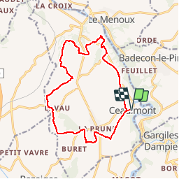
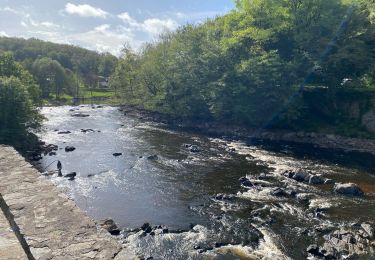
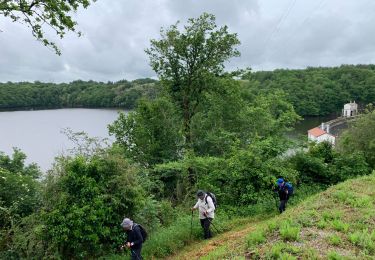
Randonnée Marche de 15,1 km à découvrir à Centre-Val de Loire, Indre, Ceaulmont. Cette randonnée est proposée par Phil36.
Description
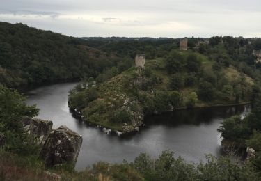
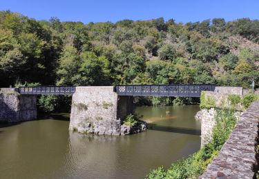
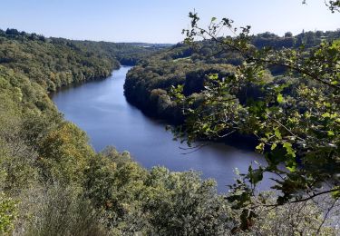
Riveraine de la Creuse sur une quinzaine de kilomètres entre le pont Noir et le Vivier, la commune de Ceaulmont compte de nombreux moulins hérités de l'exploitation de l'énergie hydroulique.
Localisation
Pays :
France
Région :
Centre-Val de Loire
Département/Province :
Indre
Commune :
Ceaulmont
Localité :
Unknown
Départ:(Dec)
Départ:(UTM)
391036 ; 5153172 (31T) N.
Commentaires
Randonnées à proximité
![Randonnée Marche Gargilesse-Dampierre - SityTrail - La Chaumerette - Gargilesse - Photo](https://media.geolcdn.com/t/375/260/ext.jpg?maxdim=2&url=https%3A%2F%2Fstatic1.geolcdn.com%2Fsiteimages%2Fupload%2Ffiles%2F1553511878bg_sport_marche.png)
![Marche Marche](https://static1.geolcdn.com/sitytour/trail-icons/101.png)
SityTrail - La Chaumerette - Gargilesse
Marche
Très difficile
(1)
Gargilesse-Dampierre,
Centre-Val de Loire,
Indre,
France
![](/images/other/stat-length.png)
15,8 km | 19,7 km-effort
4h 28min
![](https://static1.geolcdn.com/siteimages/upload/files/16400158638029165_repeat_loop_refresh_sync_direction_icon.png)
Oui
![Randonnée A pied Gargilesse-Dampierre - La Gargilesse secrète et sauvage - Photo](https://media.geolcdn.com/t/375/260/f45fabfe-9f8e-4791-bb71-f646d5039a7b.jpeg&format=jpg&maxdim=2)
![A pied A pied](https://static1.geolcdn.com/sitytour/trail-icons/100.png)
La Gargilesse secrète et sauvage
A pied
Facile
Gargilesse-Dampierre,
Centre-Val de Loire,
Indre,
France
![](/images/other/stat-length.png)
6,7 km | 8,3 km-effort
1h 53min
![](https://static1.geolcdn.com/siteimages/upload/files/16400158638029165_repeat_loop_refresh_sync_direction_icon.png)
Non
![Randonnée Marche Gargilesse-Dampierre - Compostelle etape 13 - Photo](https://media.geolcdn.com/t/375/260/392da69d-726a-4863-8547-359569904a75.jpg&format=jpg&maxdim=2)
![Marche Marche](https://static1.geolcdn.com/sitytour/trail-icons/101.png)
Compostelle etape 13
Marche
Difficile
Gargilesse-Dampierre,
Centre-Val de Loire,
Indre,
France
![](/images/other/stat-length.png)
29 km | 39 km-effort
9h 58min
![](https://static1.geolcdn.com/siteimages/upload/files/16400158638029165_repeat_loop_refresh_sync_direction_icon.png)
Non
![Randonnée Marche Gargilesse-Dampierre - Beau parcours au départ du moulin de Gargilesse - Photo](https://media.geolcdn.com/t/375/260/fa1c368f-74d0-46db-8d60-0af1fbae6602.jpg&format=jpg&maxdim=2)
![Marche Marche](https://static1.geolcdn.com/sitytour/trail-icons/101.png)
Beau parcours au départ du moulin de Gargilesse
Marche
Très facile
Gargilesse-Dampierre,
Centre-Val de Loire,
Indre,
France
![](/images/other/stat-length.png)
16,2 km | 21 km-effort
3h 48min
![](https://static1.geolcdn.com/siteimages/upload/files/16400158638029165_repeat_loop_refresh_sync_direction_icon.png)
Oui
![Randonnée V.T.T. Le Menoux - Vallée de la Creuse 1 - Photo](https://media.geolcdn.com/t/375/260/ext.jpg?maxdim=2&url=https%3A%2F%2Fstatic1.geolcdn.com%2Fsiteimages%2Fupload%2Ffiles%2F1524743154velo.jpg)
![V.T.T. V.T.T.](https://static1.geolcdn.com/sitytour/trail-icons/202.png)
Vallée de la Creuse 1
V.T.T.
Moyen
(1)
Le Menoux,
Centre-Val de Loire,
Indre,
France
![](/images/other/stat-length.png)
51 km | 63 km-effort
Inconnu
![](https://static1.geolcdn.com/siteimages/upload/files/16400158638029165_repeat_loop_refresh_sync_direction_icon.png)
Non
![Randonnée Marche Gargilesse-Dampierre - La chaumerette pont des piles - Photo](https://media.geolcdn.com/t/375/260/c178561a-edbd-4064-b2a7-0ed1ebb39ac8.jpg&format=jpg&maxdim=2)
![Marche Marche](https://static1.geolcdn.com/sitytour/trail-icons/101.png)
La chaumerette pont des piles
Marche
Difficile
Gargilesse-Dampierre,
Centre-Val de Loire,
Indre,
France
![](/images/other/stat-length.png)
22 km | 27 km-effort
5h 28min
![](https://static1.geolcdn.com/siteimages/upload/files/16400158638029165_repeat_loop_refresh_sync_direction_icon.png)
Oui
![Randonnée sport Le Menoux - Sob 17 le menoux cuzion - Photo](https://media.geolcdn.com/t/375/260/a7ea09a4-f376-4dab-a4f6-85126f46f916.jpg&format=jpg&maxdim=2)
Sob 17 le menoux cuzion
sport
Très facile
Le Menoux,
Centre-Val de Loire,
Indre,
France
![](/images/other/stat-length.png)
16,6 km | 21 km-effort
Inconnu
![](https://static1.geolcdn.com/siteimages/upload/files/16400158638029165_repeat_loop_refresh_sync_direction_icon.png)
Non
![Randonnée Marche Cuzion - Cuzion - Photo](https://media.geolcdn.com/t/375/260/b03cf623-7ff8-4acd-94ea-f6c2044c2cbd.jpg&format=jpg&maxdim=2)
![Marche Marche](https://static1.geolcdn.com/sitytour/trail-icons/101.png)
Cuzion
Marche
Difficile
Cuzion,
Centre-Val de Loire,
Indre,
France
![](/images/other/stat-length.png)
13,6 km | 17,2 km-effort
3h 24min
![](https://static1.geolcdn.com/siteimages/upload/files/16400158638029165_repeat_loop_refresh_sync_direction_icon.png)
Oui
![Randonnée Marche Gargilesse-Dampierre - 1 er rando - Photo](https://media.geolcdn.com/t/375/260/ext.jpg?maxdim=2&url=https%3A%2F%2Fstatic1.geolcdn.com%2Fsiteimages%2Fupload%2Ffiles%2F1553511878bg_sport_marche.png)
![Marche Marche](https://static1.geolcdn.com/sitytour/trail-icons/101.png)
1 er rando
Marche
Très difficile
Gargilesse-Dampierre,
Centre-Val de Loire,
Indre,
France
![](/images/other/stat-length.png)
16,9 km | 20 km-effort
3h 58min
![](https://static1.geolcdn.com/siteimages/upload/files/16400158638029165_repeat_loop_refresh_sync_direction_icon.png)
Oui