![](/images/other/stat-length.png)
![Randonnée Marche Asque - Casque du Lheris - Photo](https://media.geolcdn.com/t/1900/400/ext.pjpeg?maxdim=2&url=https%3A%2F%2Fstatic1.geolcdn.com%2Fsiteimages%2Fupload%2Ffiles%2F1553511878bg_sport_marche.png)
Casque du Lheris
Polo-31
Utilisateur
![Longueur](/images/other/stat-length.png)
Longueur
14,5 km
![Altitude max](https://static1.geolcdn.com/siteimages/upload/files/1508320355ic_sort_altitude_max_24dp.png)
Altitude max
1577 m
![Dénivelé positif](https://static1.geolcdn.com/siteimages/upload/files/1508320355ic_sort_den_pos_24dp.png)
Dénivelé positif
1146 m
![Km-Effort](/images/other/stat-length.png)
Km-Effort
28 km
![Altitude min](https://static1.geolcdn.com/siteimages/upload/files/1508320355ic_sort_altitude_min_24dp.png)
Altitude min
462 m
![Dénivelé négatif](https://static1.geolcdn.com/siteimages/upload/files/1508320355ic_sort_den_neg_24dp.png)
Dénivelé négatif
682 m
![Boucle](https://static1.geolcdn.com/siteimages/upload/files/16400158638029165_repeat_loop_refresh_sync_direction_icon.png)
Boucle
Non
Date de création :
2017-01-04 00:00:00.0
Dernière modification :
2017-01-04 00:00:00.0
![Marche](https://static1.geolcdn.com/sitytour/trail-icons/101.png)
5h00
Difficulté : Moyen
![Scannez ce code QR pour ouvrir la randonnée dans l'application SityTrail](https://capi.geolives.com/qq0zvz2zws4bq2lad0pu/sitytour/trails/680033/qr.png?size=200)
Application GPS de randonnée GRATUITE
À propos
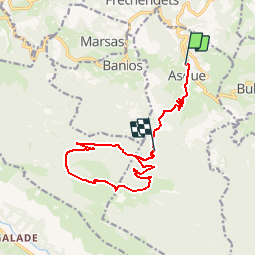
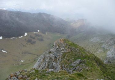
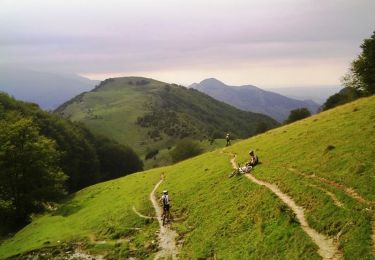
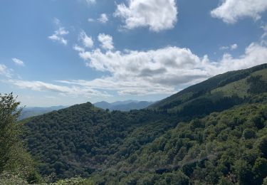
Randonnée Marche de 14,5 km à découvrir à Occitanie, Hautes-Pyrénées, Asque. Cette randonnée est proposée par Polo-31.
Description
Trace réalisée le 31/12/2016.
La 1ere partie jusqu'au parking (alt 920m) n'a pas trop d'intérêt. C'est pour cela que le retour depuis ce parking a été fait en voiture.
Localisation
Pays :
France
Région :
Occitanie
Département/Province :
Hautes-Pyrénées
Commune :
Asque
Localité :
Unknown
Départ:(Dec)
Départ:(UTM)
276442 ; 4769560 (31T) N.
Commentaires
Randonnées à proximité
![Randonnée Marche Asque - Asque G3 2023 soum det Raygade - Photo](https://media.geolcdn.com/t/375/260/c51a294e-3986-44fb-b83d-5eec65b57f41.jpg&format=jpg&maxdim=2)
![Marche Marche](https://static1.geolcdn.com/sitytour/trail-icons/101.png)
Asque G3 2023 soum det Raygade
Marche
Difficile
(1)
Asque,
Occitanie,
Hautes-Pyrénées,
France
![](/images/other/stat-length.png)
9,8 km | 16,7 km-effort
3h 47min
![](https://static1.geolcdn.com/siteimages/upload/files/16400158638029165_repeat_loop_refresh_sync_direction_icon.png)
Oui
![Randonnée sport Asque - CA Asque en Baronnies par le soum det Raygade 605... - Photo](https://media.geolcdn.com/t/375/260/ext.jpg?maxdim=2&url=https%3A%2F%2Fsecurestorage.geolives.com%2Fsitytour%2Ftrail-bg%2Fdefault.jpg)
CA Asque en Baronnies par le soum det Raygade 605...
sport
Très facile
(1)
Asque,
Occitanie,
Hautes-Pyrénées,
France
![](/images/other/stat-length.png)
9,8 km | 16,6 km-effort
Inconnu
![](https://static1.geolcdn.com/siteimages/upload/files/16400158638029165_repeat_loop_refresh_sync_direction_icon.png)
Oui
![Randonnée Marche Castillon - FEU 2015 - Etape 4 - Photo](https://media.geolcdn.com/t/375/260/ext.jpg?maxdim=2&url=https%3A%2F%2Fstatic1.geolcdn.com%2Fsiteimages%2Fupload%2Ffiles%2F1553511878bg_sport_marche.png)
![Marche Marche](https://static1.geolcdn.com/sitytour/trail-icons/101.png)
FEU 2015 - Etape 4
Marche
Facile
(2)
Castillon,
Occitanie,
Hautes-Pyrénées,
France
![](/images/other/stat-length.png)
11,6 km | 18,1 km-effort
3h 43min
![](https://static1.geolcdn.com/siteimages/upload/files/16400158638029165_repeat_loop_refresh_sync_direction_icon.png)
Non
![Randonnée Marche Gerde - Casque du Lheris - Photo](https://media.geolcdn.com/t/375/260/127d6360-7ed6-475e-a89b-3eca1405854b.jpg&format=jpg&maxdim=2)
![Marche Marche](https://static1.geolcdn.com/sitytour/trail-icons/101.png)
Casque du Lheris
Marche
Moyen
Gerde,
Occitanie,
Hautes-Pyrénées,
France
![](/images/other/stat-length.png)
16,8 km | 28 km-effort
6h 25min
![](https://static1.geolcdn.com/siteimages/upload/files/16400158638029165_repeat_loop_refresh_sync_direction_icon.png)
Oui
![Randonnée Marche Batsère - batsere G3 fait - Photo](https://media.geolcdn.com/t/375/260/76a9ffa0-70a8-4cfd-8688-a85e78503952.jpg&format=jpg&maxdim=2)
![Marche Marche](https://static1.geolcdn.com/sitytour/trail-icons/101.png)
batsere G3 fait
Marche
Très facile
Batsère,
Occitanie,
Hautes-Pyrénées,
France
![](/images/other/stat-length.png)
13 km | 19,4 km-effort
4h 57min
![](https://static1.geolcdn.com/siteimages/upload/files/16400158638029165_repeat_loop_refresh_sync_direction_icon.png)
Oui
![Randonnée Marche Asque - Loubetas - Photo](https://media.geolcdn.com/t/375/260/ext.jpg?maxdim=2&url=https%3A%2F%2Fservices.sitytrail.com%2FGeolivesWS%2FDownloadMedia.ashx%3FTrailID%3D562222%26Media%3D20160426141141.jpg)
![Marche Marche](https://static1.geolcdn.com/sitytour/trail-icons/101.png)
Loubetas
Marche
Facile
Asque,
Occitanie,
Hautes-Pyrénées,
France
![](/images/other/stat-length.png)
18,5 km | 26 km-effort
5h 18min
![](https://static1.geolcdn.com/siteimages/upload/files/16400158638029165_repeat_loop_refresh_sync_direction_icon.png)
Oui
![Randonnée Marche Gerde - Casque du Lhéris - Gerde - Photo](https://media.geolcdn.com/t/375/260/ext.jpg?maxdim=2&url=https%3A%2F%2Fservices.sitytrail.com%2FGeolivesWS%2FDownloadMedia.ashx%3FTrailID%3D172521%26Media%3D13880_4.jpg)
![Marche Marche](https://static1.geolcdn.com/sitytour/trail-icons/101.png)
Casque du Lhéris - Gerde
Marche
Moyen
Gerde,
Occitanie,
Hautes-Pyrénées,
France
![](/images/other/stat-length.png)
14,1 km | 24 km-effort
5h 0min
![](https://static1.geolcdn.com/siteimages/upload/files/16400158638029165_repeat_loop_refresh_sync_direction_icon.png)
Oui
![Randonnée V.T.T. Asté - Bagnères de Bigorre bis VTT - Photo](https://media.geolcdn.com/t/375/260/ext.jpg?maxdim=2&url=https%3A%2F%2Fservices.sitytrail.com%2FGeolivesWS%2FDownloadMedia.ashx%3FTrailID%3D100959%26Media%3D458_3.jpg)
![V.T.T. V.T.T.](https://static1.geolcdn.com/sitytour/trail-icons/202.png)
Bagnères de Bigorre bis VTT
V.T.T.
Difficile
Asté,
Occitanie,
Hautes-Pyrénées,
France
![](/images/other/stat-length.png)
23 km | 36 km-effort
2h 30min
![](https://static1.geolcdn.com/siteimages/upload/files/16400158638029165_repeat_loop_refresh_sync_direction_icon.png)
Oui
![Randonnée Marche Gerde - Col des Palomieres et Pic de Castets - Photo](https://media.geolcdn.com/t/375/260/c30cafa7-b386-48a5-b0f6-6bcdba0d19c1.jpg&format=jpg&maxdim=2)
![Marche Marche](https://static1.geolcdn.com/sitytour/trail-icons/101.png)
Col des Palomieres et Pic de Castets
Marche
Moyen
Gerde,
Occitanie,
Hautes-Pyrénées,
France
![](/images/other/stat-length.png)
5,2 km | 8,2 km-effort
1h 40min
![](https://static1.geolcdn.com/siteimages/upload/files/16400158638029165_repeat_loop_refresh_sync_direction_icon.png)
Oui