![](/images/other/stat-length.png)
![Randonnée Marche Neuilly-sur-Marne - Neuilly-Noisiel - Photo](https://media.geolcdn.com/t/1900/400/ext.pjpeg?maxdim=2&url=https%3A%2F%2Fstatic1.geolcdn.com%2Fsiteimages%2Fupload%2Ffiles%2F1553511878bg_sport_marche.png)
Neuilly-Noisiel
jctinchebray
Utilisateur
![Longueur](/images/other/stat-length.png)
Longueur
14,5 km
![Altitude max](https://static1.geolcdn.com/siteimages/upload/files/1508320355ic_sort_altitude_max_24dp.png)
Altitude max
58 m
![Dénivelé positif](https://static1.geolcdn.com/siteimages/upload/files/1508320355ic_sort_den_pos_24dp.png)
Dénivelé positif
78 m
![Km-Effort](/images/other/stat-length.png)
Km-Effort
15,6 km
![Altitude min](https://static1.geolcdn.com/siteimages/upload/files/1508320355ic_sort_altitude_min_24dp.png)
Altitude min
34 m
![Dénivelé négatif](https://static1.geolcdn.com/siteimages/upload/files/1508320355ic_sort_den_neg_24dp.png)
Dénivelé négatif
78 m
![Boucle](https://static1.geolcdn.com/siteimages/upload/files/16400158638029165_repeat_loop_refresh_sync_direction_icon.png)
Boucle
Oui
Date de création :
2018-04-13 07:31:17.931
Dernière modification :
2018-04-13 07:31:17.931
![Marche](https://static1.geolcdn.com/sitytour/trail-icons/101.png)
3h28
Difficulté : Facile
![Scannez ce code QR pour ouvrir la randonnée dans l'application SityTrail](https://capi.geolives.com/qq0zvz2zws4bq2lad0pu/sitytour/trails/678239/qr.png?size=200)
Application GPS de randonnée GRATUITE
À propos
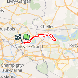
Randonnée Marche de 14,5 km à découvrir à Île-de-France, Seine-Saint-Denis, Neuilly-sur-Marne. Cette randonnée est proposée par jctinchebray.
Description
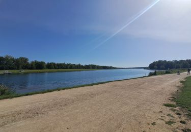
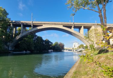
Randonnée de 15 km au départ de l'écluse de Neuilly sur marne et passant par la haute ile, Gournay, Champs sur marne en longeant la marne
Localisation
Pays :
France
Région :
Île-de-France
Département/Province :
Seine-Saint-Denis
Commune :
Neuilly-sur-Marne
Localité :
Unknown
Départ:(Dec)
Départ:(UTM)
466117 ; 5411316 (31U) N.
Commentaires
Randonnées à proximité
![Randonnée Marche Neuilly-Plaisance - Neuilly Plaisance gare Rer sortie Bords de Marne/ Base Nautique Vaires sur Marne - Photo](https://media.geolcdn.com/t/375/260/3fb9e5a2-0030-4f1a-a960-e880d0c7625d.jpg&format=jpg&maxdim=2)
![Marche Marche](https://static1.geolcdn.com/sitytour/trail-icons/101.png)
Neuilly Plaisance gare Rer sortie Bords de Marne/ Base Nautique Vaires sur Marne
Marche
Facile
(1)
Neuilly-Plaisance,
Île-de-France,
Seine-Saint-Denis,
France
![](/images/other/stat-length.png)
15,9 km | 17,1 km-effort
2h 52min
![](https://static1.geolcdn.com/siteimages/upload/files/16400158638029165_repeat_loop_refresh_sync_direction_icon.png)
Oui
![Randonnée Marche Chelles - GRP CV-IDF 12R Chelles à Emerainville - Photo](https://media.geolcdn.com/t/375/260/3e851a57-05bf-470c-9490-37cd07bf40e9.jpg&format=jpg&maxdim=2)
![Marche Marche](https://static1.geolcdn.com/sitytour/trail-icons/101.png)
GRP CV-IDF 12R Chelles à Emerainville
Marche
Moyen
(1)
Chelles,
Île-de-France,
Seine-et-Marne,
France
![](/images/other/stat-length.png)
15 km | 16,7 km-effort
3h 47min
![](https://static1.geolcdn.com/siteimages/upload/files/16400158638029165_repeat_loop_refresh_sync_direction_icon.png)
Non
![Randonnée Marche Champs-sur-Marne - Boucle 20 km autour de Champs sur Marne - Photo](https://media.geolcdn.com/t/375/260/e5bc49c5-8534-4b14-8b85-21b9437dca8c.jpg&format=jpg&maxdim=2)
![Marche Marche](https://static1.geolcdn.com/sitytour/trail-icons/101.png)
Boucle 20 km autour de Champs sur Marne
Marche
Facile
Champs-sur-Marne,
Île-de-France,
Seine-et-Marne,
France
![](/images/other/stat-length.png)
19,8 km | 22 km-effort
4h 29min
![](https://static1.geolcdn.com/siteimages/upload/files/16400158638029165_repeat_loop_refresh_sync_direction_icon.png)
Oui
![Randonnée A pied Champigny-sur-Marne - Sur les bords de Marne - Photo](https://media.geolcdn.com/t/375/260/0848a8c4-6d65-4224-9dca-3686da6f2272.jpg&format=jpg&maxdim=2)
![A pied A pied](https://static1.geolcdn.com/sitytour/trail-icons/100.png)
Sur les bords de Marne
A pied
Moyen
Champigny-sur-Marne,
Île-de-France,
Val-de-Marne,
France
![](/images/other/stat-length.png)
32 km | 35 km-effort
7h 52min
![](https://static1.geolcdn.com/siteimages/upload/files/16400158638029165_repeat_loop_refresh_sync_direction_icon.png)
Oui
![Randonnée Marche Saint-Maur-des-Fossés - Boucle St Maur - Vincennes - Photo](https://media.geolcdn.com/t/375/260/07d4e882-57e1-4d05-a0e2-c5807ef2ec4c.jpg&format=jpg&maxdim=2)
![Marche Marche](https://static1.geolcdn.com/sitytour/trail-icons/101.png)
Boucle St Maur - Vincennes
Marche
Saint-Maur-des-Fossés,
Île-de-France,
Val-de-Marne,
France
![](/images/other/stat-length.png)
22 km | 24 km-effort
5h 32min
![](https://static1.geolcdn.com/siteimages/upload/files/16400158638029165_repeat_loop_refresh_sync_direction_icon.png)
Oui
![Randonnée Marche Gournay-sur-Marne - Boucle Gournay/ Marne - Noisy le Grand - Champs sur Marne - Photo](https://media.geolcdn.com/t/375/260/89921577-96fb-496f-92ce-fb28ab23f5a4.jpg&format=jpg&maxdim=2)
![Marche Marche](https://static1.geolcdn.com/sitytour/trail-icons/101.png)
Boucle Gournay/ Marne - Noisy le Grand - Champs sur Marne
Marche
Très facile
Gournay-sur-Marne,
Île-de-France,
Seine-Saint-Denis,
France
![](/images/other/stat-length.png)
20 km | 23 km-effort
4h 41min
![](https://static1.geolcdn.com/siteimages/upload/files/16400158638029165_repeat_loop_refresh_sync_direction_icon.png)
Oui
![Randonnée V.T.T. Fontenay-sous-Bois - vtt bois de vincennes - Photo](https://media.geolcdn.com/t/375/260/ext.jpg?maxdim=2&url=https%3A%2F%2Fstatic1.geolcdn.com%2Fsiteimages%2Fupload%2Ffiles%2F1524743154velo.jpg)
![V.T.T. V.T.T.](https://static1.geolcdn.com/sitytour/trail-icons/202.png)
vtt bois de vincennes
V.T.T.
Moyen
(1)
Fontenay-sous-Bois,
Île-de-France,
Val-de-Marne,
France
![](/images/other/stat-length.png)
38 km | 42 km-effort
1h 59min
![](https://static1.geolcdn.com/siteimages/upload/files/16400158638029165_repeat_loop_refresh_sync_direction_icon.png)
Oui
![Randonnée Marche Champigny-sur-Marne - BM Bord de Marne : Nogent-Gournay AR 21km - Photo](https://media.geolcdn.com/t/375/260/d8a7ca9d-36a1-43a8-b0ad-da38a2a2adfc.jpg&format=jpg&maxdim=2)
![Marche Marche](https://static1.geolcdn.com/sitytour/trail-icons/101.png)
BM Bord de Marne : Nogent-Gournay AR 21km
Marche
Très difficile
Champigny-sur-Marne,
Île-de-France,
Val-de-Marne,
France
![](/images/other/stat-length.png)
21 km | 23 km-effort
5h 10min
![](https://static1.geolcdn.com/siteimages/upload/files/16400158638029165_repeat_loop_refresh_sync_direction_icon.png)
Oui
![Randonnée Marche Nogent-sur-Marne - 2023 06 25 - Photo](https://media.geolcdn.com/t/375/260/5e8f4917-23cc-40cc-a8e3-6d600f9f06b3.jpg&format=jpg&maxdim=2)
![Marche Marche](https://static1.geolcdn.com/sitytour/trail-icons/101.png)
2023 06 25
Marche
Très difficile
Nogent-sur-Marne,
Île-de-France,
Val-de-Marne,
France
![](/images/other/stat-length.png)
17,4 km | 19,3 km-effort
3h 45min
![](https://static1.geolcdn.com/siteimages/upload/files/16400158638029165_repeat_loop_refresh_sync_direction_icon.png)
Oui