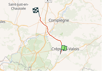
![](/images/other/stat-length.png)
![Randonnée Autre activité ORMOY-VILLERS - Picardie - Ligne 232 - Ormoy-Villers - Boves (section de Estrées-St-Denis à Ormoy-Villers) - Photo](https://media.geolcdn.com/t/1900/400/ext.pjpeg?maxdim=2&url=https%3A%2F%2Fstatic1.geolcdn.com%2Fsiteimages%2Fupload%2Ffiles%2F1545311037marcheuse_200dpi.jpg)
Picardie - Ligne 232 - Ormoy-Villers - Boves (section de Estrées-St-Denis à Ormoy-Villers)
mich54
Utilisateur
![Longueur](/images/other/stat-length.png)
![Altitude max](https://static1.geolcdn.com/siteimages/upload/files/1508320355ic_sort_altitude_max_24dp.png)
![Dénivelé positif](https://static1.geolcdn.com/siteimages/upload/files/1508320355ic_sort_den_pos_24dp.png)
![Km-Effort](/images/other/stat-length.png)
![Altitude min](https://static1.geolcdn.com/siteimages/upload/files/1508320355ic_sort_altitude_min_24dp.png)
![Dénivelé négatif](https://static1.geolcdn.com/siteimages/upload/files/1508320355ic_sort_den_neg_24dp.png)
![Boucle](https://static1.geolcdn.com/siteimages/upload/files/16400158638029165_repeat_loop_refresh_sync_direction_icon.png)
![Autre activité](https://static1.geolcdn.com/sitytour/trail-icons/900.png)
5m
Difficulté : Inconnu
![Scannez ce code QR pour ouvrir la randonnée dans l'application SityTrail](https://capi.geolives.com/qq0zvz2zws4bq2lad0pu/sitytour/trails/667042/qr.png?size=200)
Application GPS de randonnée GRATUITE
À propos
Randonnée Autre activité de 35 km à découvrir à Hauts-de-France, Oise. Cette randonnée est proposée par mich54.
Description
La ligne d'Ormoy-Villers à Boves est une ligne ferroviaire qui relie la banlieue parisienne nord-est à la région d'Amiens. Très utilisée au temps de la traction à vapeur pour acheminer le charbon du bassin houiller du nord de la France vers la région parisienne, en évitant ainsi l'emprunt de la section Amiens - Paris très chargée, elle est utilisée aujourd'hui pour le trafic des marchandises entre Ormoy-Villers et la ligne de Creil à Jeumont et en trafic voyageurs entre Estrées-Saint-Denis et Boves (relation entre Compiègne et Amiens).
Elle constitue la ligne 232 0001 du réseau ferré national.(Source Wikipédia)
Localisation
Commentaires
Randonnées à proximité
![Randonnée Marche Versigny - SM_DROIZELLES_ 8Km - Photo](https://media.geolcdn.com/t/375/260/f65b74ad-26ab-4b6b-97d1-92bea4466b40.jpg&format=jpg&maxdim=2)
![Marche Marche](https://static1.geolcdn.com/sitytour/trail-icons/101.png)
Marche
![](/images/other/stat-length.png)
![](https://static1.geolcdn.com/siteimages/upload/files/16400158638029165_repeat_loop_refresh_sync_direction_icon.png)
![Randonnée Marche Péroy-les-Gombries - SM_PEROY-LES-GOMBRIES_8.4KM - Photo](https://media.geolcdn.com/t/375/260/1ec4a825-3b6c-44d9-9b96-15f24dcd8ce5.jpg&format=jpg&maxdim=2)
![Marche Marche](https://static1.geolcdn.com/sitytour/trail-icons/101.png)
Marche
![](/images/other/stat-length.png)
![](https://static1.geolcdn.com/siteimages/upload/files/16400158638029165_repeat_loop_refresh_sync_direction_icon.png)
![Randonnée Marche Auger-Saint-Vincent - SM_AUGER-Saint-VINCENT_8.8Km - Photo](https://media.geolcdn.com/t/375/260/0fa42189-56de-41a9-ac5a-5c591c7c2e51.jpg&format=jpg&maxdim=2)
![Marche Marche](https://static1.geolcdn.com/sitytour/trail-icons/101.png)
Marche
![](/images/other/stat-length.png)
![](https://static1.geolcdn.com/siteimages/upload/files/16400158638029165_repeat_loop_refresh_sync_direction_icon.png)
![Randonnée A pied Crépy-en-Valois - Boucle 24 km Crépy en Valois - Duvy - Trumily - Rocquemont - Photo](https://media.geolcdn.com/t/375/260/280ca2ce-af52-47b9-81c4-4fc64d53f4f3.jpg&format=jpg&maxdim=2)
![A pied A pied](https://static1.geolcdn.com/sitytour/trail-icons/100.png)
A pied
![](/images/other/stat-length.png)
![](https://static1.geolcdn.com/siteimages/upload/files/16400158638029165_repeat_loop_refresh_sync_direction_icon.png)
![Randonnée Marche Ormoy-Villers - Geocache Ancienne sablière - Photo](https://media.geolcdn.com/t/375/260/ext.jpg?maxdim=2&url=https%3A%2F%2Fstatic1.geolcdn.com%2Fsiteimages%2Fupload%2Ffiles%2F1553511878bg_sport_marche.png)
![Marche Marche](https://static1.geolcdn.com/sitytour/trail-icons/101.png)
Marche
![](/images/other/stat-length.png)
![](https://static1.geolcdn.com/siteimages/upload/files/16400158638029165_repeat_loop_refresh_sync_direction_icon.png)
![Randonnée Vélo Boissy-Fresnoy - Voie verte du Valois - Photo](https://media.geolcdn.com/t/375/260/ext.jpg?maxdim=2&url=https%3A%2F%2Fservices.sitytrail.com%2FGeolivesWS%2FDownloadMedia.ashx%3FTrailID%3D838150%26Media%3D63399dab-15c4-4e3e-b52f-4ba03efd3015.JPG)
![Vélo Vélo](https://static1.geolcdn.com/sitytour/trail-icons/200.png)
Vélo
![](/images/other/stat-length.png)
![](https://static1.geolcdn.com/siteimages/upload/files/16400158638029165_repeat_loop_refresh_sync_direction_icon.png)
![Randonnée Moteur Crépy-en-Valois - Randoguide - Photo](https://media.geolcdn.com/t/375/260/ext.jpg?maxdim=2&url=https%3A%2F%2Fstatic1.geolcdn.com%2Fsiteimages%2Fupload%2Ffiles%2F15247431544x4.jpg)
![Moteur Moteur](https://static1.geolcdn.com/sitytour/trail-icons/400.png)
Moteur
![](/images/other/stat-length.png)
![](https://static1.geolcdn.com/siteimages/upload/files/16400158638029165_repeat_loop_refresh_sync_direction_icon.png)
![Randonnée Marche - SM_ROSIERES-NORD_8.6Km - Photo](https://media.geolcdn.com/t/375/260/cdc8e3b3-f714-4b51-ae55-8d263b9a3239.jpg&format=jpg&maxdim=2)
![Marche Marche](https://static1.geolcdn.com/sitytour/trail-icons/101.png)
Marche
![](/images/other/stat-length.png)
![](https://static1.geolcdn.com/siteimages/upload/files/16400158638029165_repeat_loop_refresh_sync_direction_icon.png)
![Randonnée V.T.C. Lévignen - Voie verte de Valois - Photo](https://media.geolcdn.com/t/375/260/efdd8419-a69a-438b-b463-1c8a8473c49d.jpg&format=jpg&maxdim=2)
![V.T.C. V.T.C.](https://static1.geolcdn.com/sitytour/trail-icons/203.png)
V.T.C.
![](/images/other/stat-length.png)
![](https://static1.geolcdn.com/siteimages/upload/files/16400158638029165_repeat_loop_refresh_sync_direction_icon.png)