Randonnée Marche nordique Aumont-en-Halatte - Départ Aumont en H - Photo
 domifon
domifon

Utilisateur

© OpenStreetMap contributors
Longueur
Longueur
14,7 km
Altitude max
Altitude max
148 m
Dénivelé positif
Dénivelé positif
165 m
Km-Effort
Km-Effort  
16,9 km
Altitude min
Altitude min
82 m
Dénivelé négatif
Dénivelé négatif
167 m
Boucle
Boucle
Oui
Date de création :
2014-12-10 00:00:00.0
Dernière modification :
2014-12-10 00:00:00.0

(0 Avis)

Marche nordique
Marche nordique
--
Difficulté : Inconnu

Scannez ce code QR pour ouvrir la randonnée dans l'application SityTrail

Application GPS de randonnée GRATUITE

Logo SityTrail SityTrail

IGN / Instituts géographiques

Télécharger SityTrail sur l'App Store Télécharger SityTrail sur Google Play

Logo SityTrail SityTrail World

Le monde est à vous

Télécharger SityTrail sur l'App Store Télécharger SityTrail sur Google Play Télécharger SityTrail sur Huawei AppGallery

À propos

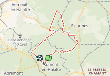
Randonnée Marche nordique de 14,7 km à découvrir à Hauts-de-France, Oise, Aumont-en-Halatte. Cette randonnée est proposée par domifon.

Description

Depart Pkg Aumont en Halatte puis 14.6 kms

Profil altimétrique

Localisation

Pays :
France
Région :
Hauts-de-France
Département/Province :
Oise
Commune :
Aumont-en-Halatte
Localité :
Unknown
Départ:(Dec)
Départ:(UTM)
466968 ; 5453213 (31U) N.

Randonnées à proximité

Randonnée A pied Senlis - SENLIS CITE ROYALE (FFK) - Photo
A pied
GR77LP

A pied

Très facile
(1)
Senlis, Hauts-de-France, Oise, France
4,6 km | 5,2 km-effort
2h 0min
Oui
Randonnée Marche Fleurines - Fleurines Grand parcours - Photo
Marche
CC.RIDER

Marche

Facile
(1)
Fleurines, Hauts-de-France, Oise, France
20 km | 24 km-effort
5h 8min
Oui
Randonnée Marche Apremont - apremont 60300 - Photo
Marche
dartoisclaude

Marche

Difficile
(1)
Apremont, Hauts-de-France, Oise, France
20 km | 23 km-effort
4h 49min
Oui
Randonnée Marche Chamant - Chamant Supermini-rando - Photo
Marche
CC.RIDER

Marche

Facile
(8)
Chamant, Hauts-de-France, Oise, France
8 km | 9,3 km-effort
2h 7min
Oui
Randonnée A pied Senlis - De Orrouy à Coye - Photo
A pied
PRO

A pied

Facile
Senlis, Hauts-de-France, Oise, France
10,1 km | 11,2 km-effort
2h 33min
Non
Randonnée A pied Aumont-en-Halatte - Chemin Royal - Photo
A pied
PRO

A pied

Facile
Aumont-en-Halatte, Hauts-de-France, Oise, France
3,5 km | 4 km-effort
54min
Non
Randonnée Marche Avilly-Saint-Léonard - randonnée en forêt de chantilly - Photo
Marche
jumetz philippe

Marche

Très facile
Avilly-Saint-Léonard, Hauts-de-France, Oise, France
12,1 km | 13,2 km-effort
2h 54min
Oui
Randonnée Marche Fleurines - Fleurines_StChristophe_12,7 km_Trace GPS - Photo
Marche
Pousscailleux

Marche

Moyen
(1)
Fleurines, Hauts-de-France, Oise, France
12,7 km | 15,6 km-effort
2h 42min
Oui
Randonnée V.T.T. Chantilly - Dans la forêt de Chantilly - Photo
V.T.T.
tracegps

V.T.T.

Moyen
Chantilly, Hauts-de-France, Oise, France
19,7 km | 22 km-effort
1h 30min
Oui


Fermer
Mes abonnements