![](/images/other/stat-length.png)
![Randonnée Marche Aizier - Aizier La Mare Au Sourd Noêl 2016 (40) - Photo](https://media.geolcdn.com/t/1900/400/ext.pjpeg?maxdim=2&url=https%3A%2F%2Fstatic1.geolcdn.com%2Fsiteimages%2Fupload%2Ffiles%2F1553511878bg_sport_marche.png)
Aizier La Mare Au Sourd Noêl 2016 (40)
randovivi
Utilisateur
![Longueur](/images/other/stat-length.png)
Longueur
10,8 km
![Altitude max](https://static1.geolcdn.com/siteimages/upload/files/1508320355ic_sort_altitude_max_24dp.png)
Altitude max
127 m
![Dénivelé positif](https://static1.geolcdn.com/siteimages/upload/files/1508320355ic_sort_den_pos_24dp.png)
Dénivelé positif
272 m
![Km-Effort](/images/other/stat-length.png)
Km-Effort
14,4 km
![Altitude min](https://static1.geolcdn.com/siteimages/upload/files/1508320355ic_sort_altitude_min_24dp.png)
Altitude min
5 m
![Dénivelé négatif](https://static1.geolcdn.com/siteimages/upload/files/1508320355ic_sort_den_neg_24dp.png)
Dénivelé négatif
272 m
![Boucle](https://static1.geolcdn.com/siteimages/upload/files/16400158638029165_repeat_loop_refresh_sync_direction_icon.png)
Boucle
Oui
Date de création :
2016-12-16 00:00:00.0
Dernière modification :
2016-12-16 00:00:00.0
![Marche](https://static1.geolcdn.com/sitytour/trail-icons/101.png)
3h07
Difficulté : Moyen
![Scannez ce code QR pour ouvrir la randonnée dans l'application SityTrail](https://capi.geolives.com/qq0zvz2zws4bq2lad0pu/sitytour/trails/656660/qr.png?size=200)
Application GPS de randonnée GRATUITE
À propos
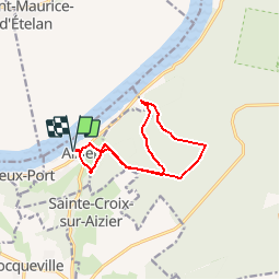
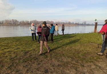
Randonnée Marche de 10,8 km à découvrir à Normandie, Eure, Aizier. Cette randonnée est proposée par randovivi.
Description
Départ Parking du cimetière d'Aizier descendre la rue jusqu'au bas du cul de sac (un peu plus bas que l'église) pour garer les voitures.
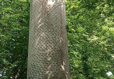
Prendre les Bâtons.
Deux belles Côtes. Attention terrain glissant quand il pleut
Localisation
Pays :
France
Région :
Normandie
Département/Province :
Eure
Commune :
Aizier
Localité :
Unknown
Départ:(Dec)
Départ:(UTM)
327788 ; 5478096 (31U) N.
Commentaires
Randonnées à proximité
![Randonnée Marche Trouville-la-Haule - Randonnée à Trouville la Haule - Photo](https://media.geolcdn.com/t/375/260/ext.jpg?maxdim=2&url=https%3A%2F%2Fservices.sitytrail.com%2FGeolivesWS%2FDownloadMedia.ashx%3FTrailID%3D107363%26Media%3D12260_1.jpg)
![Marche Marche](https://static1.geolcdn.com/sitytour/trail-icons/101.png)
Randonnée à Trouville la Haule
Marche
Moyen
(1)
Trouville-la-Haule,
Normandie,
Eure,
France
![](/images/other/stat-length.png)
14,6 km | 18,6 km-effort
3h 19min
![](https://static1.geolcdn.com/siteimages/upload/files/16400158638029165_repeat_loop_refresh_sync_direction_icon.png)
Oui
![Randonnée Marche Aizier - Aizier vers Vieux Port (100) - Photo](https://media.geolcdn.com/t/375/260/ext.jpg?maxdim=2&url=https%3A%2F%2Fstatic1.geolcdn.com%2Fsiteimages%2Fupload%2Ffiles%2F1553511878bg_sport_marche.png)
![Marche Marche](https://static1.geolcdn.com/sitytour/trail-icons/101.png)
Aizier vers Vieux Port (100)
Marche
Facile
(3)
Aizier,
Normandie,
Eure,
France
![](/images/other/stat-length.png)
12,2 km | 14,9 km-effort
3h 15min
![](https://static1.geolcdn.com/siteimages/upload/files/16400158638029165_repeat_loop_refresh_sync_direction_icon.png)
Oui
![Randonnée Marche Aizier - Chemin des sources bleues - Photo](https://media.geolcdn.com/t/375/260/633716cc-f4d9-4f6e-b990-1d93204857d2.jpg&format=jpg&maxdim=2)
![Marche Marche](https://static1.geolcdn.com/sitytour/trail-icons/101.png)
Chemin des sources bleues
Marche
Moyen
Aizier,
Normandie,
Eure,
France
![](/images/other/stat-length.png)
7,3 km | 9,6 km-effort
2h 11min
![](https://static1.geolcdn.com/siteimages/upload/files/16400158638029165_repeat_loop_refresh_sync_direction_icon.png)
Oui
![Randonnée Marche Aizier - Vieux-Port, de la forêt aux rives de la Seine - Photo](https://media.geolcdn.com/t/375/260/1cf5f8b3-c967-4acc-8c96-742a1fa1812d.jpg&format=jpg&maxdim=2)
![Marche Marche](https://static1.geolcdn.com/sitytour/trail-icons/101.png)
Vieux-Port, de la forêt aux rives de la Seine
Marche
Moyen
Aizier,
Normandie,
Eure,
France
![](/images/other/stat-length.png)
4,8 km | 6,5 km-effort
1h 37min
![](https://static1.geolcdn.com/siteimages/upload/files/16400158638029165_repeat_loop_refresh_sync_direction_icon.png)
Oui
![Randonnée Marche La Haye-Aubrée - La Haye Aubrée - Le chemin aux Anes- Version 03-04 - Photo](https://media.geolcdn.com/t/375/260/39d82811-b877-4248-9e61-2979148c8df2.jpg&format=jpg&maxdim=2)
![Marche Marche](https://static1.geolcdn.com/sitytour/trail-icons/101.png)
La Haye Aubrée - Le chemin aux Anes- Version 03-04
Marche
Difficile
La Haye-Aubrée,
Normandie,
Eure,
France
![](/images/other/stat-length.png)
12,7 km | 14,8 km-effort
3h 19min
![](https://static1.geolcdn.com/siteimages/upload/files/16400158638029165_repeat_loop_refresh_sync_direction_icon.png)
Oui
![Randonnée Marche Trouville-la-Haule - Trouville la Haule . Chemin du Courval - Photo](https://media.geolcdn.com/t/375/260/b18ccded-32f9-499d-b58c-a18fcc72914b.jpg&format=jpg&maxdim=2)
![Marche Marche](https://static1.geolcdn.com/sitytour/trail-icons/101.png)
Trouville la Haule . Chemin du Courval
Marche
Difficile
(1)
Trouville-la-Haule,
Normandie,
Eure,
France
![](/images/other/stat-length.png)
11,8 km | 14,5 km-effort
3h 3min
![](https://static1.geolcdn.com/siteimages/upload/files/16400158638029165_repeat_loop_refresh_sync_direction_icon.png)
Oui
![Randonnée Marche Bourneville-Sainte-Croix - Bourneville-sainte-Croix- Le petit Brotonne - Photo](https://media.geolcdn.com/t/375/260/f3ccac4c-21c3-4eb7-b8a8-bd0b0eee06ac.jpg&format=jpg&maxdim=2)
![Marche Marche](https://static1.geolcdn.com/sitytour/trail-icons/101.png)
Bourneville-sainte-Croix- Le petit Brotonne
Marche
Difficile
Bourneville-Sainte-Croix,
Normandie,
Eure,
France
![](/images/other/stat-length.png)
14,1 km | 16,2 km-effort
3h 23min
![](https://static1.geolcdn.com/siteimages/upload/files/16400158638029165_repeat_loop_refresh_sync_direction_icon.png)
Oui
![Randonnée Marche Aizier - brotonne 2 - Photo](https://media.geolcdn.com/t/375/260/ext.jpg?maxdim=2&url=https%3A%2F%2Fstatic1.geolcdn.com%2Fsiteimages%2Fupload%2Ffiles%2F1553511878bg_sport_marche.png)
![Marche Marche](https://static1.geolcdn.com/sitytour/trail-icons/101.png)
brotonne 2
Marche
Très facile
(3)
Aizier,
Normandie,
Eure,
France
![](/images/other/stat-length.png)
14,3 km | 18,8 km-effort
4h 2min
![](https://static1.geolcdn.com/siteimages/upload/files/16400158638029165_repeat_loop_refresh_sync_direction_icon.png)
Oui
![Randonnée Marche Bourneville-Sainte-Croix - les sources bleues - Photo](https://media.geolcdn.com/t/375/260/779dddc5-8d72-4e2e-a14f-aa43a57fc4c9.jpg&format=jpg&maxdim=2)
![Marche Marche](https://static1.geolcdn.com/sitytour/trail-icons/101.png)
les sources bleues
Marche
Très facile
(1)
Bourneville-Sainte-Croix,
Normandie,
Eure,
France
![](/images/other/stat-length.png)
6,3 km | 8,4 km-effort
1h 45min
![](https://static1.geolcdn.com/siteimages/upload/files/16400158638029165_repeat_loop_refresh_sync_direction_icon.png)
Oui