![](/images/other/stat-length.png)
![Randonnée Marche Stekene - Stiltegebied Klein Sinaai ( 9,5 km) StepAway.be - Photo](https://media.geolcdn.com/t/1900/400/ext.pjpeg?maxdim=2&url=https%3A%2F%2Fstatic1.geolcdn.com%2Fsiteimages%2Fupload%2Ffiles%2F1553511878bg_sport_marche.png)
Stiltegebied Klein Sinaai ( 9,5 km) StepAway.be
corry.vandenbroeke
Utilisateur
![Longueur](/images/other/stat-length.png)
Longueur
9,7 km
![Altitude max](https://static1.geolcdn.com/siteimages/upload/files/1508320355ic_sort_altitude_max_24dp.png)
Altitude max
9 m
![Dénivelé positif](https://static1.geolcdn.com/siteimages/upload/files/1508320355ic_sort_den_pos_24dp.png)
Dénivelé positif
46 m
![Km-Effort](/images/other/stat-length.png)
Km-Effort
10,3 km
![Altitude min](https://static1.geolcdn.com/siteimages/upload/files/1508320355ic_sort_altitude_min_24dp.png)
Altitude min
0 m
![Dénivelé négatif](https://static1.geolcdn.com/siteimages/upload/files/1508320355ic_sort_den_neg_24dp.png)
Dénivelé négatif
45 m
![Boucle](https://static1.geolcdn.com/siteimages/upload/files/16400158638029165_repeat_loop_refresh_sync_direction_icon.png)
Boucle
Oui
Date de création :
2016-10-26 00:00:00.0
Dernière modification :
2016-10-26 00:00:00.0
![Marche](https://static1.geolcdn.com/sitytour/trail-icons/101.png)
2h18
Difficulté : Très facile
![Scannez ce code QR pour ouvrir la randonnée dans l'application SityTrail](https://capi.geolives.com/qq0zvz2zws4bq2lad0pu/sitytour/trails/651170/qr.png?size=200)
Application GPS de randonnée GRATUITE
À propos
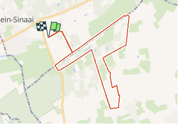
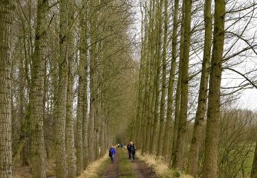
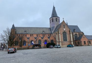
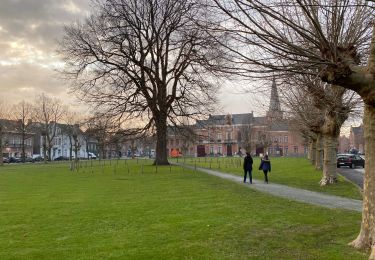
Randonnée Marche de 9,7 km à découvrir à Flandre, Flandre orientale, Stekene. Cette randonnée est proposée par corry.vandenbroeke.
Description
Start Klein sinaai. Helft van de wandeling verharde weg en dus niet echt geschikt voor Nordic walking. maar wel een heel mooi gebied. Wandeling uitgestippeld door StepAway.be
Localisation
Pays :
Belgique
Région :
Flandre
Département/Province :
Flandre orientale
Commune :
Stekene
Localité :
Stekene
Départ:(Dec)
Départ:(UTM)
569918 ; 5670346 (31U) N.
Commentaires
Randonnées à proximité
![Randonnée A pied Lokeren - Liniewegelroute - Photo](https://media.geolcdn.com/t/375/260/ext.jpg?maxdim=2&url=https%3A%2F%2Fmedia.geolcdn.com%2Ff%2F62ae4cc3-6e72-4c51-bc3b-95bdff6e887b.jpeg)
![A pied A pied](https://static1.geolcdn.com/sitytour/trail-icons/100.png)
Liniewegelroute
A pied
Facile
Lokeren,
Flandre,
Flandre orientale,
Belgique
![](/images/other/stat-length.png)
8,4 km | 9 km-effort
2h 2min
![](https://static1.geolcdn.com/siteimages/upload/files/16400158638029165_repeat_loop_refresh_sync_direction_icon.png)
Oui
![Randonnée A pied Moerbeke - Pereboomsgat Wandelroute - Photo](https://media.geolcdn.com/t/375/260/ext.jpg?maxdim=2&url=https%3A%2F%2Fmedia.geolcdn.com%2Ff%2F3a2bc327-0df1-42c6-8878-457c212415cf.jpeg)
![A pied A pied](https://static1.geolcdn.com/sitytour/trail-icons/100.png)
Pereboomsgat Wandelroute
A pied
Facile
Moerbeke,
Flandre,
Flandre orientale,
Belgique
![](/images/other/stat-length.png)
8,5 km | 8,9 km-effort
2h 1min
![](https://static1.geolcdn.com/siteimages/upload/files/16400158638029165_repeat_loop_refresh_sync_direction_icon.png)
Non
![Randonnée Marche Stekene - Wullebos - Klein Sinaai (6km) (StepAway.be) - Photo](https://media.geolcdn.com/t/375/260/ext.jpg?maxdim=2&url=https%3A%2F%2Fstatic1.geolcdn.com%2Fsiteimages%2Fupload%2Ffiles%2F1553511878bg_sport_marche.png)
![Marche Marche](https://static1.geolcdn.com/sitytour/trail-icons/101.png)
Wullebos - Klein Sinaai (6km) (StepAway.be)
Marche
Facile
(1)
Stekene,
Flandre,
Flandre orientale,
Belgique
![](/images/other/stat-length.png)
5,9 km | 6,5 km-effort
1h 26min
![](https://static1.geolcdn.com/siteimages/upload/files/16400158638029165_repeat_loop_refresh_sync_direction_icon.png)
Oui
![Randonnée Marche Moerbeke - Moerbeke 26,5 km - Photo](https://media.geolcdn.com/t/375/260/ext.jpg?maxdim=2&url=https%3A%2F%2Fmedia.geolcdn.com%2Ff%2F35628380-609b-479d-af04-77325e1722d8.jpg)
![Marche Marche](https://static1.geolcdn.com/sitytour/trail-icons/101.png)
Moerbeke 26,5 km
Marche
Moyen
Moerbeke,
Flandre,
Flandre orientale,
Belgique
![](/images/other/stat-length.png)
27 km | 28 km-effort
5h 44min
![](https://static1.geolcdn.com/siteimages/upload/files/16400158638029165_repeat_loop_refresh_sync_direction_icon.png)
Oui
![Randonnée A pied Saint-Nicolas - Fondatie van Boudeloroute - Photo](https://media.geolcdn.com/t/375/260/ext.jpg?maxdim=2&url=https%3A%2F%2Fmedia.geolcdn.com%2Ff%2F8e5b7271-48e9-4cd7-899b-9ae7b9cc4a80.jpeg)
![A pied A pied](https://static1.geolcdn.com/sitytour/trail-icons/100.png)
Fondatie van Boudeloroute
A pied
Facile
Saint-Nicolas,
Flandre,
Flandre orientale,
Belgique
![](/images/other/stat-length.png)
6 km | 6,5 km-effort
1h 28min
![](https://static1.geolcdn.com/siteimages/upload/files/16400158638029165_repeat_loop_refresh_sync_direction_icon.png)
Oui
![Randonnée Marche Stekene - Stekene 24 km - Photo](https://media.geolcdn.com/t/375/260/ext.jpg?maxdim=2&url=https%3A%2F%2Fmedia.geolcdn.com%2Ff%2Ffec1aeec-483e-4c6f-b7bd-2e96b05a7549.jpg)
![Marche Marche](https://static1.geolcdn.com/sitytour/trail-icons/101.png)
Stekene 24 km
Marche
Moyen
Stekene,
Flandre,
Flandre orientale,
Belgique
![](/images/other/stat-length.png)
24 km | 26 km-effort
5h 33min
![](https://static1.geolcdn.com/siteimages/upload/files/16400158638029165_repeat_loop_refresh_sync_direction_icon.png)
Oui
![Randonnée Marche Saint-Nicolas - Sinaai bis 22,9 km - Photo](https://media.geolcdn.com/t/375/260/ext.jpg?maxdim=2&url=https%3A%2F%2Fmedia.geolcdn.com%2Ff%2F9fd9e1dc-7fca-48aa-aa20-c76237cf4a8e.jpg)
![Marche Marche](https://static1.geolcdn.com/sitytour/trail-icons/101.png)
Sinaai bis 22,9 km
Marche
Facile
Saint-Nicolas,
Flandre,
Flandre orientale,
Belgique
![](/images/other/stat-length.png)
23 km | 24 km-effort
5h 12min
![](https://static1.geolcdn.com/siteimages/upload/files/16400158638029165_repeat_loop_refresh_sync_direction_icon.png)
Oui
![Randonnée Marche Saint-Nicolas - Sinaai 23 km - Photo](https://media.geolcdn.com/t/375/260/ext.jpg?maxdim=2&url=https%3A%2F%2Fmedia.geolcdn.com%2Ff%2F41153e4c-b05c-4034-85e3-cf7e03465de5.jpg)
![Marche Marche](https://static1.geolcdn.com/sitytour/trail-icons/101.png)
Sinaai 23 km
Marche
Facile
Saint-Nicolas,
Flandre,
Flandre orientale,
Belgique
![](/images/other/stat-length.png)
23 km | 24 km-effort
5h 9min
![](https://static1.geolcdn.com/siteimages/upload/files/16400158638029165_repeat_loop_refresh_sync_direction_icon.png)
Oui
![Randonnée Marche Lokeren - liniewegel - Photo](https://media.geolcdn.com/t/375/260/ext.jpg?maxdim=2&url=https%3A%2F%2Fstatic1.geolcdn.com%2Fsiteimages%2Fupload%2Ffiles%2F1553511878bg_sport_marche.png)
![Marche Marche](https://static1.geolcdn.com/sitytour/trail-icons/101.png)
liniewegel
Marche
Très facile
(1)
Lokeren,
Flandre,
Flandre orientale,
Belgique
![](/images/other/stat-length.png)
8,4 km | 9 km-effort
Inconnu
![](https://static1.geolcdn.com/siteimages/upload/files/16400158638029165_repeat_loop_refresh_sync_direction_icon.png)
Oui