![](/images/other/stat-length.png)
![Randonnée Marche Zumaia - ZUMAIA - DEBA - Photo](https://media.geolcdn.com/t/1900/400/8523cbfa-cbd3-4333-8367-5e802b367cac.jpg&format=pjpeg&maxdim=2)
ZUMAIA - DEBA
DECHAMPD
Utilisateur
![Longueur](/images/other/stat-length.png)
![Altitude max](https://static1.geolcdn.com/siteimages/upload/files/1508320355ic_sort_altitude_max_24dp.png)
![Dénivelé positif](https://static1.geolcdn.com/siteimages/upload/files/1508320355ic_sort_den_pos_24dp.png)
![Km-Effort](/images/other/stat-length.png)
![Altitude min](https://static1.geolcdn.com/siteimages/upload/files/1508320355ic_sort_altitude_min_24dp.png)
![Dénivelé négatif](https://static1.geolcdn.com/siteimages/upload/files/1508320355ic_sort_den_neg_24dp.png)
![Boucle](https://static1.geolcdn.com/siteimages/upload/files/16400158638029165_repeat_loop_refresh_sync_direction_icon.png)
![Marche](https://static1.geolcdn.com/sitytour/trail-icons/101.png)
4h13
Difficulté : Difficile
![Scannez ce code QR pour ouvrir la randonnée dans l'application SityTrail](https://capi.geolives.com/qq0zvz2zws4bq2lad0pu/sitytour/trails/645594/qr.png?size=200)
Application GPS de randonnée GRATUITE
À propos
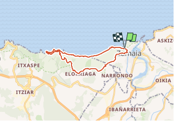
Randonnée Marche de 13,6 km à découvrir à Pays basque autonome, Guipuscoa, Zumaia. Cette randonnée est proposée par DECHAMPD.
Description
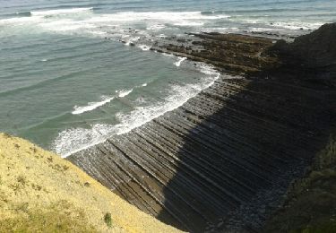
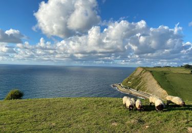
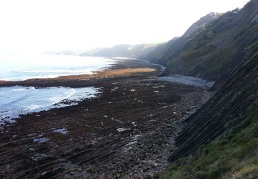
Sur cet itinéraire, non adapté aux marcheurs, avec deux parties très clairement différenciées, il est très important de garder à l'esprit ce qui suit par rapport à la première partie de celui-ci. Vous voyagez tout le temps au-dessus du niveau de la marée, il est donc essentiel de prévoir que cela se fasse à marée basse, avec un coefficient de marée de 101 et les jours de vives eaux. Comme nous passerons sous les falaises d'Itzurun, si nécessaire, nous ne pourrons pas quitter le niveau de la marée, donc si la marée montante nous atteignait, nous serions dans de très sérieux ennuis. Il existe quelques issues de secours, mais elles sont très peu nombreuses. J'ai marqué l'itinéraire comme difficile, non pas à cause de la distance, ni à cause des dénivelés accumulés, mais parce que nous marcherons presque sans interruption sur une succession constante de couches rocheuses, dont beaucoup sont pointues et glissantes, un accident sous forme de chute pourrait soyez très sérieux pour nous. En prenant les précautions nécessaires, vous profiterez d'un superbe spectacle géologique de la nature, mais en grand. L'évasion se fait par le WP marqué "corde", puisque nous utilisons une corde placée là pour gravir facilement le chemin, le long duquel nous retournerons confortablement et dans une agréable promenade à Zumaia. Le point de départ et d'arrivée est l'ermitage de San Telmo, dans la partie élevée de la ville.
Localisation
Commentaires
Randonnées à proximité
![Randonnée Marche Getaria - JFT YB Étape 26 24-5-2014 - Photo](https://media.geolcdn.com/t/375/260/ext.jpg?maxdim=2&url=https%3A%2F%2Fservices.sitytrail.com%2FGeolivesWS%2FDownloadMedia.ashx%3FTrailID%3D304855%26Media%3Dfix__20140524104124.jpg)
![Marche Marche](https://static1.geolcdn.com/sitytour/trail-icons/101.png)
Marche
![](/images/other/stat-length.png)
![](https://static1.geolcdn.com/siteimages/upload/files/16400158638029165_repeat_loop_refresh_sync_direction_icon.png)
![Randonnée Marche Getaria - Zumaia - Photo](https://media.geolcdn.com/t/375/260/b8fda268-989f-4b28-a0e2-5b9b7a80af56.jpg&format=jpg&maxdim=2)
![Marche Marche](https://static1.geolcdn.com/sitytour/trail-icons/101.png)
Marche
![](/images/other/stat-length.png)
![](https://static1.geolcdn.com/siteimages/upload/files/16400158638029165_repeat_loop_refresh_sync_direction_icon.png)
![Randonnée Marche Deba - ZUMAIA G4 2024 - Photo](https://media.geolcdn.com/t/375/260/56d7f409-bf89-49b1-b457-4e56063bbfab.jpg&format=jpg&maxdim=2)
![Marche Marche](https://static1.geolcdn.com/sitytour/trail-icons/101.png)
Marche
![](/images/other/stat-length.png)
![](https://static1.geolcdn.com/siteimages/upload/files/16400158638029165_repeat_loop_refresh_sync_direction_icon.png)
![Randonnée Marche Getaria - Getaria zaraost - Photo](https://media.geolcdn.com/t/375/260/adda4d22-c241-4bc8-8254-22dd46679f93.jpg&format=jpg&maxdim=2)
![Marche Marche](https://static1.geolcdn.com/sitytour/trail-icons/101.png)
Marche
![](/images/other/stat-length.png)
![](https://static1.geolcdn.com/siteimages/upload/files/16400158638029165_repeat_loop_refresh_sync_direction_icon.png)
![Randonnée Marche Zumaia - Zumaia à DEBA 2016 10 18 - Photo](https://media.geolcdn.com/t/375/260/ext.jpg?maxdim=2&url=https%3A%2F%2Fservices.sitytrail.com%2FGeolivesWS%2FDownloadMedia.ashx%3FTrailID%3D647915%26Media%3Dfix__20161018124258.jpg)
![Marche Marche](https://static1.geolcdn.com/sitytour/trail-icons/101.png)
Marche
![](/images/other/stat-length.png)
![](https://static1.geolcdn.com/siteimages/upload/files/16400158638029165_repeat_loop_refresh_sync_direction_icon.png)
![Randonnée Marche Deba - SityTrail - Elioraga Deba G3 - Photo](https://media.geolcdn.com/t/375/260/ext.jpg?maxdim=2&url=https%3A%2F%2Fstatic1.geolcdn.com%2Fsiteimages%2Fupload%2Ffiles%2F1553511878bg_sport_marche.png)
![Marche Marche](https://static1.geolcdn.com/sitytour/trail-icons/101.png)
Marche
![](/images/other/stat-length.png)
![](https://static1.geolcdn.com/siteimages/upload/files/16400158638029165_repeat_loop_refresh_sync_direction_icon.png)
![Randonnée Marche Deba - elgorriaga-DebaG2 - Photo](https://media.geolcdn.com/t/375/260/ext.jpg?maxdim=2&url=https%3A%2F%2Fstatic1.geolcdn.com%2Fsiteimages%2Fupload%2Ffiles%2F1553511878bg_sport_marche.png)
![Marche Marche](https://static1.geolcdn.com/sitytour/trail-icons/101.png)
Marche
![](/images/other/stat-length.png)
![](https://static1.geolcdn.com/siteimages/upload/files/16400158638029165_repeat_loop_refresh_sync_direction_icon.png)
![Randonnée Marche Getaria - 003 Getaria - Ibiri - Photo](https://media.geolcdn.com/t/375/260/ext.jpg?maxdim=2&url=https%3A%2F%2Fstatic1.geolcdn.com%2Fsiteimages%2Fupload%2Ffiles%2F1553511878bg_sport_marche.png)
![Marche Marche](https://static1.geolcdn.com/sitytour/trail-icons/101.png)
Marche
![](/images/other/stat-length.png)
![](https://static1.geolcdn.com/siteimages/upload/files/16400158638029165_repeat_loop_refresh_sync_direction_icon.png)
![Randonnée Marche Getaria - 03 Getaria Deba - Photo](https://media.geolcdn.com/t/375/260/ext.jpg?maxdim=2&url=https%3A%2F%2Fstatic1.geolcdn.com%2Fsiteimages%2Fupload%2Ffiles%2F1553511878bg_sport_marche.png)
![Marche Marche](https://static1.geolcdn.com/sitytour/trail-icons/101.png)
Marche
![](/images/other/stat-length.png)
![](https://static1.geolcdn.com/siteimages/upload/files/16400158638029165_repeat_loop_refresh_sync_direction_icon.png)